Location mapping for key-point based services

a technology of location mapping and keypoint based services, applied in the direction of wireless commuication services, navigation instruments, instruments, etc., can solve the problems of relatively high cost of devices with integral location finding capability, cost and bandwidth prohibitive, etc., to maximize user experience, minimize bandwidth requirements, cost and bandwidth

Active Publication Date: 2008-07-17
UBER TECH INC
View PDF31 Cites 380 Cited by
  • Summary
  • Abstract
  • Description
  • Claims
  • Application Information

AI Technical Summary

Benefits of technology

[0009]A “Proxi-Mapper,” as described herein, combines location based services (LBS), local searching capabilities, and relative mapping in a way that minimizes bandwidth requirements and maximizes user experience. In general, mobile data access is typically cost and bandwidth prohibitive for typical users and typical portable user devices (cell phones, PDA's, media players, etc.). Consequently, the Proxi-Mapper leverages conventional location or positioning techniques to determine approximate device locations for providing user devices with a lightweight model of local entities (“key-points”) representing businesses, services, people, transportation modalities, objects, etc. In addition, in various embodiments, the lightweight model includes metadata associated with the key-points along with proximity between the key-points in combination with local search services. This lightweight model is then used for both UI rendering purposes (textual and / or graphical) and / or for direction or mapping purposes to combine LBS and local search services into a simple framework centered on the key-points.
[0010]In other words, the Proxi-Mapper provides a set of location based solutions, requiring only approximate accuracy in terms of user location, to bring location based services to a wide range of mobile electronic devices. Device location is determined by using combinations of existing positioning technology to approximately deduce the location of one or more user devices. Conventional positioning technology leveraged by the Proxi-Mapper includes techniques such as GPS, cell phone triangulation, WiFi mapping, RFID tracking, etc. Local entities represented by key-points include businesses (restaurants, taxis, retail stores, etc.), services (government, hospital, school, etc.), people, transportation modalities, objects, etc. In addition, optional metadata associated with each key-point provides further levels of detail for each entity. As a result, the approximate user position, in combination with the location, proximity and type of various key-points, enable local (location-based) searching and services relative to business-to-customer or customer-to-customer matching.
[0011]In particular, the Proxi-Mapper includes a mapping database of key-points and location based services that are designed to enable enterprise and consumer scenarios by selectively providing key-point related data to individual user devices as a function of the approximate location of those devices. Key-points are maintained in a geographical “grid format” that groups key-points into grid sections using a normalized position for each key-point in a grid section. User devices are also approximately located relative to these grid sections. As a result, the corresponding relative location of the user and key-points in nearby grid sections enables the Proxi-Mapper to provide location based services to the user as a function of the overall grid while minimizing user device bandwidth requirements. Note that in one embodiment, the approximate location of the user device is treated as a key-point for mapping purposes.
[0012]One advantage of using the grid-based format for the mapping database of key-points is that the overall set of key-points can be viewed as a two-dimensional array, wherein particular key-points are pre-assigned to particular elements of the array. As such, it is simple to extract particular key-points from the key-point database corresponding to some range of grid sections around the user's grid location, since searches can be limited to a very small set of grid sections (array elements) around the user's grid. Further, in various embodiments, key-points presented to the user are filtered using various user-selectable criteria, such as, for example, distance, direction, availability, cost, time, shared interests, etc.

Problems solved by technology

Unfortunately, devices with integral location finding capability (including satellite-based navigation systems such as GPS, the European “Galileo” system, the Russian “Glonass” system, etc.) tend to be relatively expensive, and typically require a large amount of storage space to maintain a set of local maps, or significant bandwidth capability for downloading current maps, if available.
Further, because the maps provided with integral location finding capability are generally predefined, locally relevant information may not be available to the user with respect to recent changes in that information.
In addition, satellite-based navigation systems tend to work poorly, if at all, either indoors or in “urban canyons” where the user is surrounded by many tall buildings.
In general, mobile data access is typically cost and bandwidth prohibitive for typical users and typical portable user devices (cell phones, PDA's, media players, etc.).

Method used


Image

  • Location mapping for key-point based services
  • Location mapping for key-point based services
  • Location mapping for key-point based services

Examples


Embodiment Construction

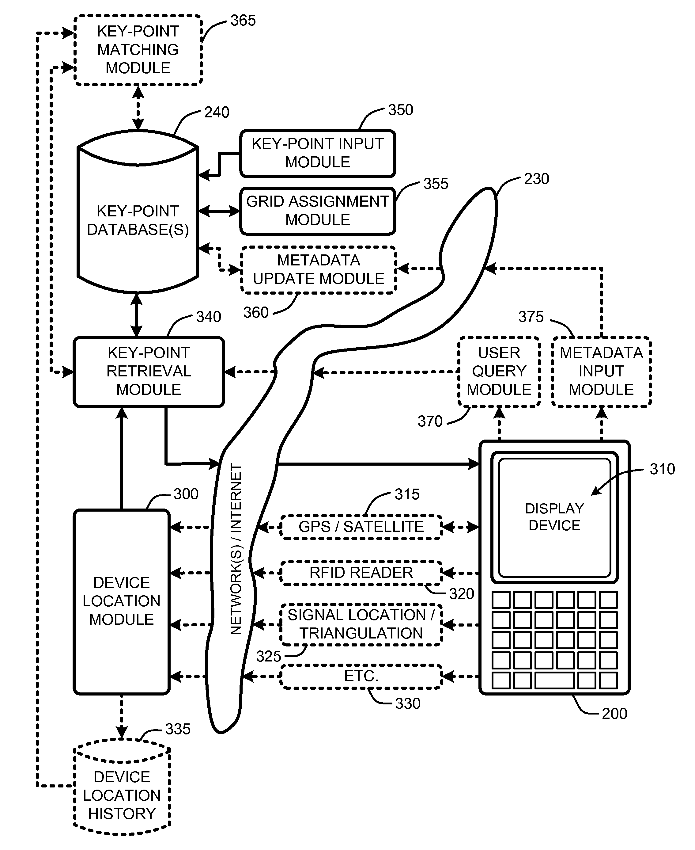
[0019]In the following description of various embodiments of the present invention, reference is made to the accompanying drawings, which form a part hereof, and in which is shown by way of illustration specific embodiments in which the invention may be practiced. It is understood that other embodiments may be utilized and structural changes may be made without departing from the scope of the present invention.

[0020]1.0 Exemplary Operating Environment:

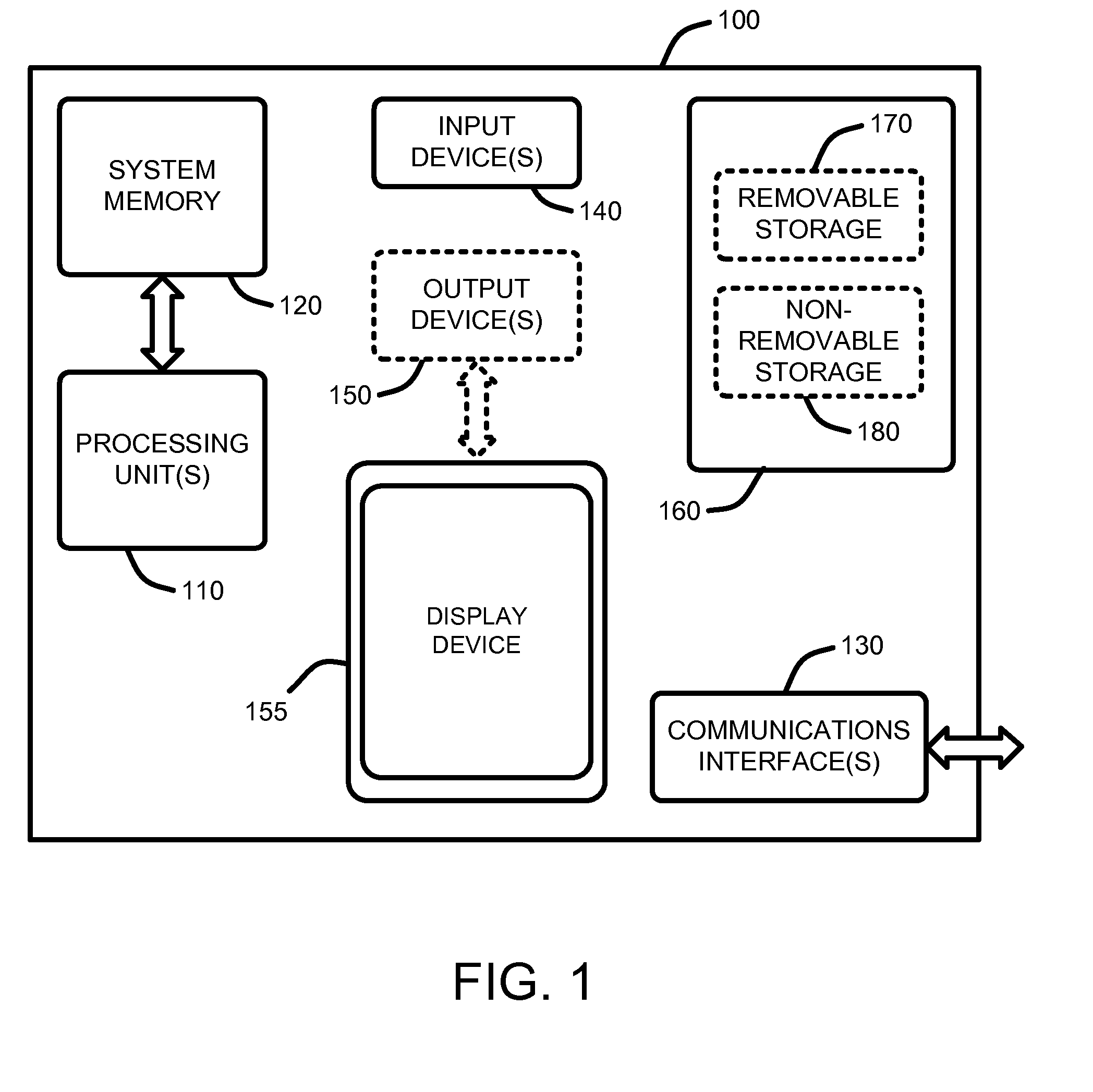
[0021]FIG. 1 illustrates an example of a simplified computing environment on which various embodiments and elements of a “Proxi-Mapper,” as described herein, may be implemented. It should be noted that any boxes that are represented by broken or dashed lines in FIG. 1 represent alternate embodiments of the simplified computing environment, as described herein, and that any or all of these alternate embodiments, as described below, may be used in combination with other alternate embodiments that are described throughout this document.

[0...


PUM


Abstract

A “Proxi-Mapper” combines location based services (LBS), local searching capabilities, and relative mapping in a way that minimizes bandwidth requirements and maximizes user experience. The Proxi-Mapper automatically determines approximate locations of one or more local user devices (cell phones, PDA's, media players, portable computing devices, etc.) and returns a lightweight model of local entities (“key-points”) representing businesses, services or people to those devices. Key-points are maintained in one or more remote databases in which key-points are assigned to predetermined grid sections based on the locations of the corresponding entities. Metadata associated with the key-points provides the user with additional information relating to the corresponding entities. In various embodiments, user query options allow the Proxi-Mapper to pull or push relevant local key-point based information to user devices via one or more wired or wireless networks.

Description

BACKGROUND[0001]1. Technical Field[0002]The invention is related to providing location-based services (LBS), and in particular, to a system for providing locally relevant information, services, and relative mapping, to one or more user devices as a function of approximate user device positions relative to a dynamic database of geographic points of interest.[0003]2. Related Art[0004]Many GPS-type location identification devices provide the user with a map of the locality surrounding the device. For example, conventional handheld GPS-type devices typically provide a graphical and / or textual street map to the user based on predefined maps accessible to the device as a function of a present location determined by the device.[0005]Unfortunately, devices with integral location finding capability (including satellite-based navigation systems such as GPS, the European “Galileo” system, the Russian “Glonass” system, etc.) tend to be relatively expensive, and typically require a large amount ...

Claims


Application Information

Patent Timeline
Patent Type & Authority Applications(United States)
IPC IPC(8): G01C21/00
CPCG01C21/30H04L67/18H04W4/02H04L67/52H04W4/029
Inventor CHANG, ERICWONG, KONG-KATTANG, DIFEI
Owner UBER TECH INC
Why Eureka
Try Eureka