Airborne turbulence location system and methods

a technology for locating turbulence and airborne aircraft, which is applied in the direction of direction finders using radio waves, clear air turbulence detection/forecasting, instruments, etc., can solve the problems of limited options available to airlines to reroute flights, no affordable, reliable way for airplanes, and limited number of options to achieve reroute flights. , to achieve the effect of increasing the air traffic system capacity

Inactive Publication Date: 2009-01-08
THE BOEING CO
View PDF3 Cites 15 Cited by
  • Summary
  • Abstract
  • Description
  • Claims
  • Application Information

AI Technical Summary

Benefits of technology

[0012]The techniques described herein can increase air traffic system capacity by more precisely pinpointing the location (range and altitude) of the t...

Problems solved by technology

However, all clear air turbulence phenomena have one thing in common: the phenomena occur in clear air, and aircraft currently have very few ways to avoid these phenomena except to maneuver or change flight altitudes once they have entered the turbulent region.
In many areas of the country, the number of options available to an airline to reroute a flight are limited due to airspace capacity or air traffic control system constraints.
There are many efforts to improve the identification of turbulent air, however, these efforts only help after one or more flights has flown into rough air, and they don't provide a way to constantly scan the airspace.
Currently, there is no affordable, reliable way for an airplane to detect CAT in time to take evasive action.
The problem with CAT is that it occurs in clear air in the absence of particulate mat...

Method used


Image

  • Airborne turbulence location system and methods
  • Airborne turbulence location system and methods
  • Airborne turbulence location system and methods

Examples


Embodiment Construction

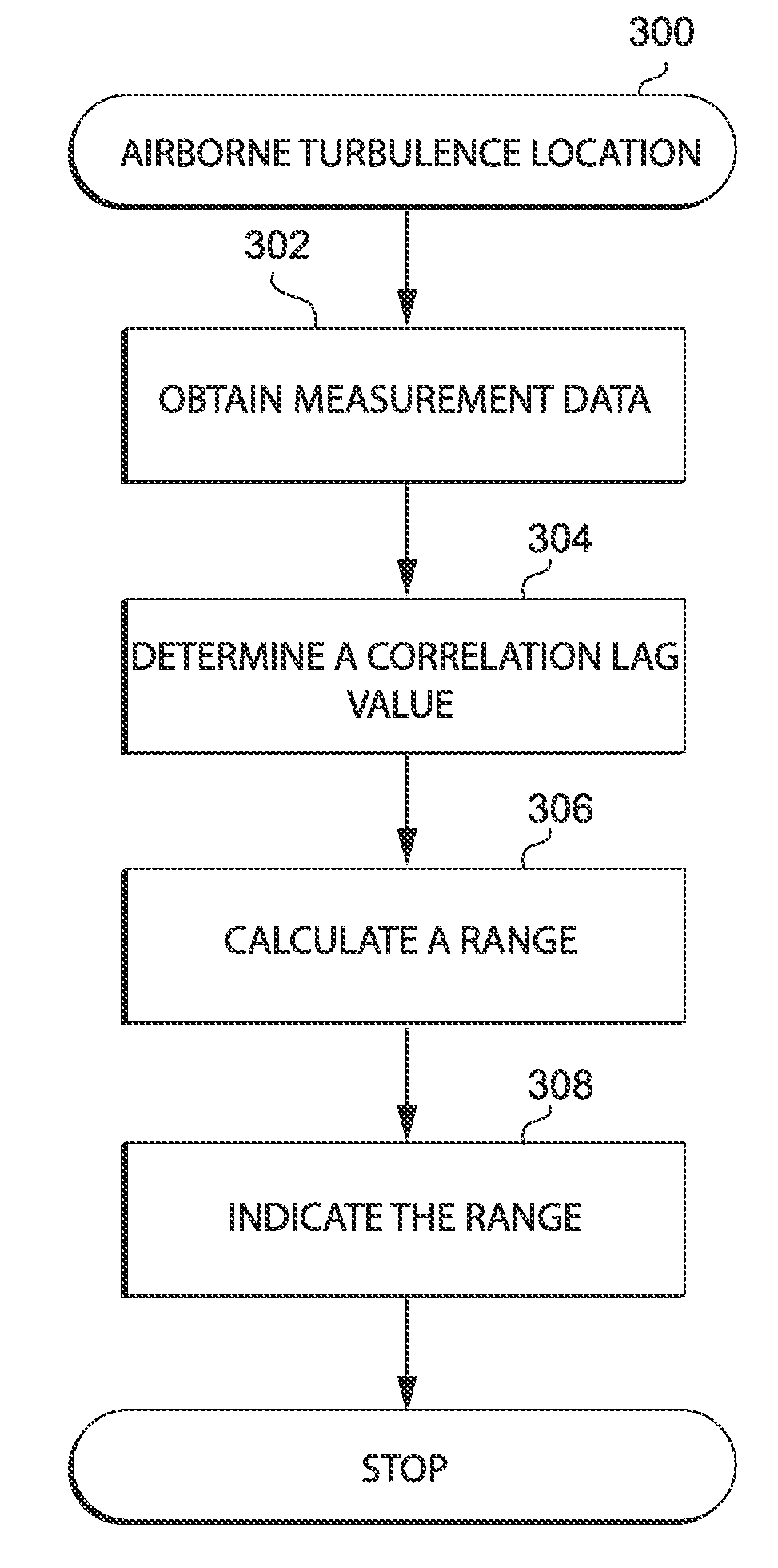
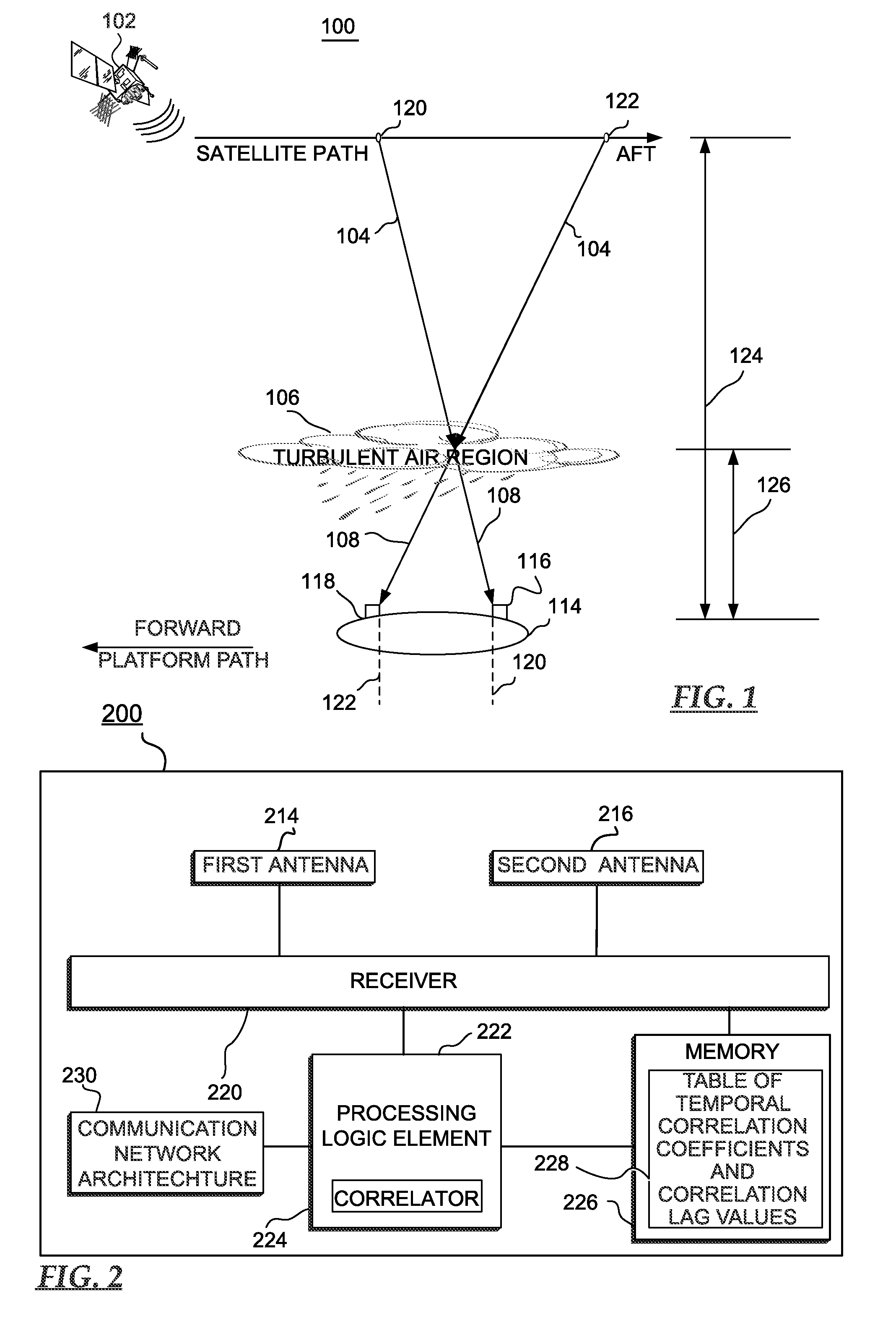
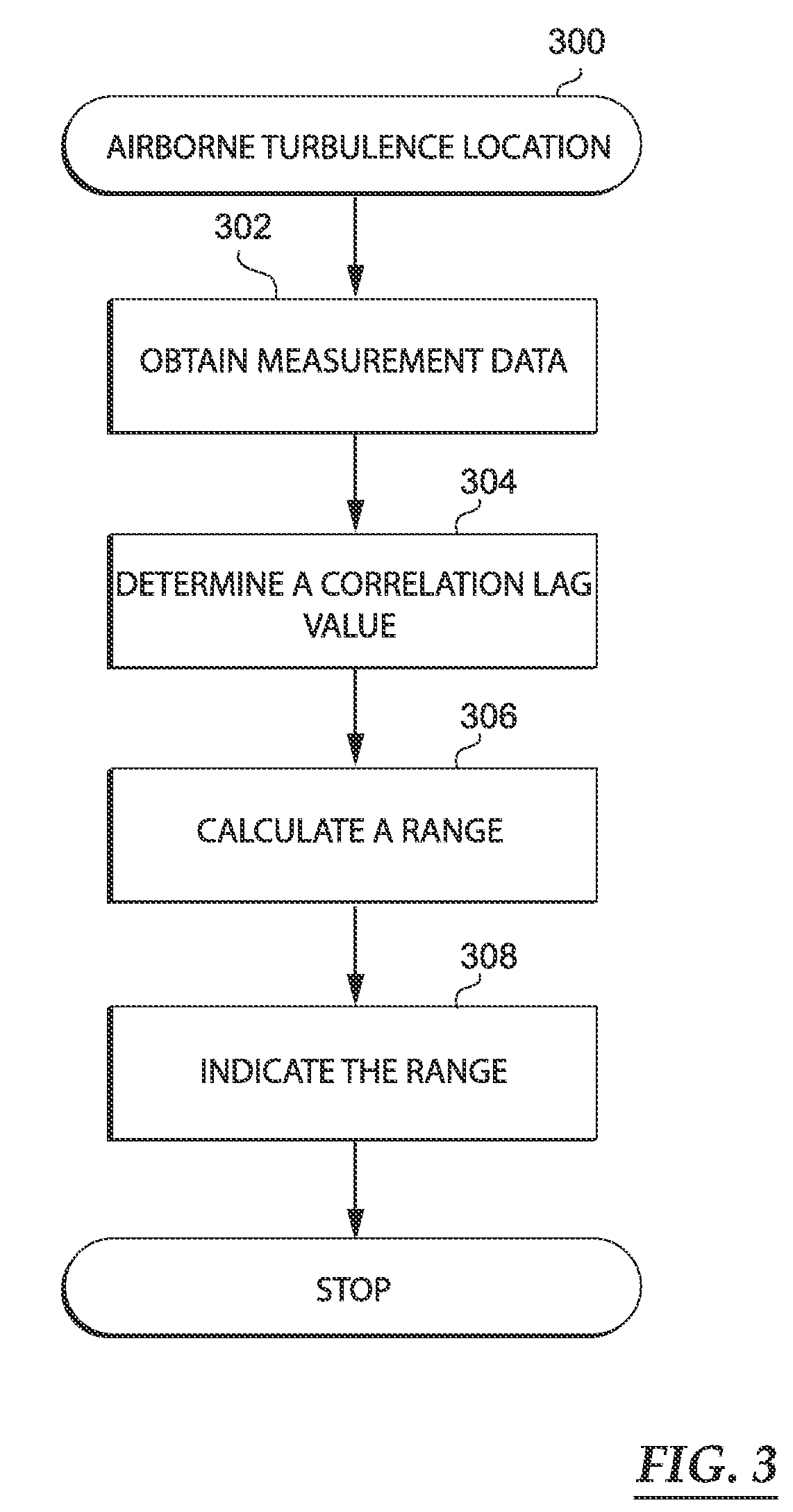
[0021]The following detailed description is merely illustrative in nature and is not intended to limit the embodiments of the invention or the application and uses of such embodiments. Furthermore, there is no intention to be bound by any expressed or implied theory presented in the preceding technical field, background, brief summary or the following detailed description.

[0022]Embodiments of the invention may be described herein in terms of functional and / or logical block components and various processing steps. It should be appreciated that such block components may be realized by any number of hardware, software, and / or firmware components configured to perform the specified functions. For example, an embodiment of the invention may employ various integrated circuit components, e.g., memory elements, digital signal processing elements, logic elements, look-up tables, or the like, which may carry out a variety of functions under the control of one or more microprocessors or other ...


PUM


Abstract

A system and methods for calculating a range to a turbulent air region from an antenna platform is disclosed. The methods determine a correlation lag value corresponding to a time shift in receiving propagation of an interference pattern traveling along a path that is subject to the turbulent air region at antennas responsive to incident electromagnetic energy. Based upon the correlation lag value, the methods calculate the range to the turbulent air region from the antenna platform and issue a warning that indicate the range.

Description

TECHNICAL FIELD[0001]The present invention generally relates to aircraft safety measures, and more particularly relates to systems for measuring the location of turbulence.BACKGROUND[0002]Clear air turbulence (CAT) occurs at typical jet cruise altitudes, due to a number of different factors, including: the location of the jet stream, the location of the tropopause boundary, the location of localized severe weather including thunderstorms, and the location of mountainous terrain. However, all clear air turbulence phenomena have one thing in common: the phenomena occur in clear air, and aircraft currently have very few ways to avoid these phenomena except to maneuver or change flight altitudes once they have entered the turbulent region.[0003]Turbulence (especially CAT), is a serious concern for air travel. Some airlines take strong measures to avoid regions of forecast or previously discovered turbulence, sometimes flying many extra miles to avoid turbulence. In many areas of the cou...

Claims


Application Information

Patent Timeline
IPC IPC(8): G01S3/16
CPCG01W1/02G01S13/955G01W2001/003Y02A90/10
Inventor TILLOTSON, BRIAN J.SINGLETON, MARISSA
Owner THE BOEING CO
Why Eureka
Try Eureka