Method and Apparatus for Capturing, Geolocating and Measuring Oblique Images

a geolocation and oblique image technology, applied in the field of photogrammetry, can solve the problems of introducing other undesirable distortions and/or inaccuracy, affecting the recognition and identification of objects depicted in ortho-rectified orthogonal images, and affecting the accuracy of the imag

Inactive Publication Date: 2009-04-16
PICTOMETRY INTERNATIONAL CORPORATION
View PDF99 Cites 29 Cited by
  • Summary
  • Abstract
  • Description
  • Claims
  • Application Information

AI Technical Summary

Problems solved by technology

Such obliqueness in an orthogonal image causes features in the image to be distorted, especially images relatively distant from the nadir point.
Although the process of ortho-rectification compensates to a degree for oblique distortions in an orthogonal image, it introduces other undesirable distortions and / or inaccuracies in the ortho-rectified orthogonal image.
Objects depicted in ortho-rectified orthogonal images may be difficult to recognize and / or identify since most observers are not accustomed to viewing objects, particularly terrestrial features, from above.
Further, ortho-rectified images contain substantially no information as to the height of terrestrial features.
Thus, although orthogonal and ortho-rectified images are useful in photogrammetry, they lack information as to the height of features depicted therein and require highly-trained analysts to interpret detail from what the images depict.
The conventional approach of forcing the variously-sized foreground and background pixels of an oblique image into a uniform size to thereby warp the image onto a coordinate system dramatically distorts the oblique image and thereby renders identification of objects and the taking of measurements of objects depicted therein a laborious and inaccurate task.
Correcting for terrain displacement within an oblique image by using an elevation model further distorts the images thereby increasing the difficulty with which measurements can be made and reducing the accuracy of any such measurements.

Method used


Image

  • Method and Apparatus for Capturing, Geolocating and Measuring Oblique Images
  • Method and Apparatus for Capturing, Geolocating and Measuring Oblique Images
  • Method and Apparatus for Capturing, Geolocating and Measuring Oblique Images

Examples


Embodiment Construction

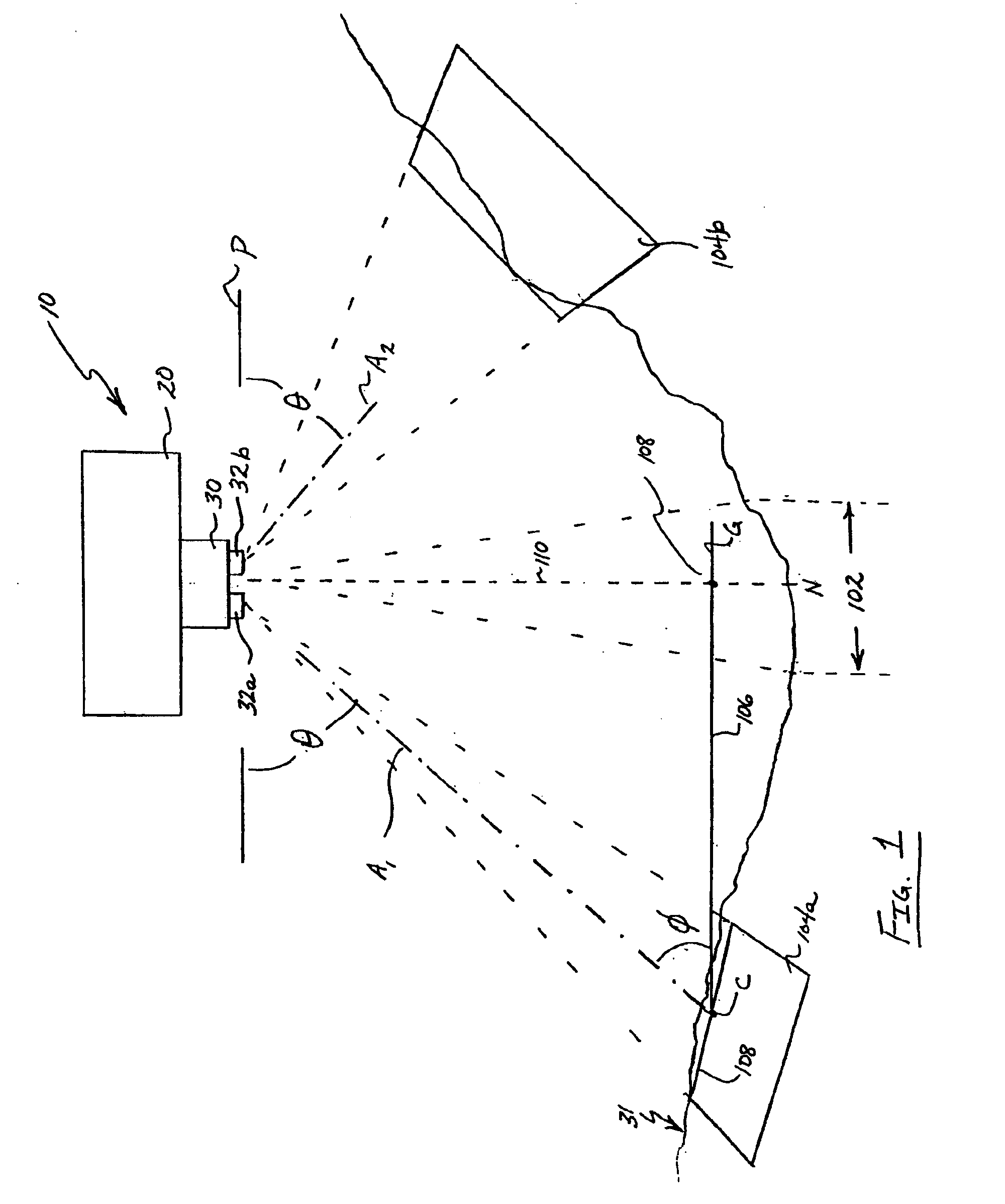
[0023]Referring now to the drawings, and particularly to FIG. 1, one embodiment of an apparatus for capturing and geolocating oblique images of the present invention is shown. Apparatus 10 includes a platform or vehicle 20 that carries image-capturing and geolocating system 30.

[0024]Platform 20, such as, for example, an airplane, space shuttle, rocket, satellite, or any other suitable vehicle, carries image-capturing system 30 over a predefined area of and at one or more predetermined altitudes above surface 31, such as, for example, the earth's surface or any other surface of interest. As such, platform 20 is capable of controlled movement or flight, either manned or unmanned, along a predefined flight path or course through, for example, the earth's atmosphere or outer space. Image capturing platform 20 includes a system for generating and regulating power (not shown) that includes, for example, one or more generators, fuel cells, solar panels, and / or batteries, for powering image...


PUM


Abstract

A computerized system for displaying, geolocating, and taking measurements from captured oblique images includes a data file accessible by the computer system. The data file includes a plurality of image files corresponding to a plurality of captured oblique images, and positional data corresponding to the images. Image display and analysis software is executed by the system for reading the data file and displaying at least a portion of the captured oblique images. The software retrieves the positional data for one or more user-selected points on the displayed image, and calculates a separation distance between any two or more selected points. The separation distance calculation is user-selectable to determine various parameters including linear distance between, area encompassed within, relative elevation of, and height difference between selected points.

Description

CROSS-REFERENCE TO RELATED APPLICATIONS[0001]This application is a continuation of Ser. No. 10 / 701,839, filed on Nov. 5, 2003, which claims priority to the provisional patent application identified by the U.S. Ser. No. 60 / 425,275, filed Nov. 8, 2002, of which the entire content of each application is hereby expressly incorporated by reference.TECHNICAL FIELD[0002]The present invention relates to photogrammetry. More particularly, the present invention relates to a method and apparatus for capturing oblique images and for measuring the objects and distances between the objects depicted therein.BACKGROUND[0003]Photogrammetry is the science of making measurements of and between objects depicted within photographs, especially aerial photographs. Generally, photogrammetry involves taking images of terrestrial features and deriving data therefrom, such as, for example, data indicating relative distances between and sizes of objects within the images. Photogrammetry may also involve coupli...

Claims


Application Information

Patent Timeline
Patent Type & Authority Applications(United States)
IPC IPC(8): H04N5/228G06K9/00G01C11/02G06T17/05
CPCG01C11/02G03B37/02G06T17/05G06K9/0063G06T2207/10032G06T7/602G06T3/4038G03B15/006G01C11/04G06T11/203G06T2207/30204G06T7/60
Inventor SCHULTZ, STEPHEN L.GIUFFRIDA, FRANK D.GRAY, ROBERT L.MONDELLO, CHARLES
Owner PICTOMETRY INTERNATIONAL CORPORATION
Why Eureka
Try Eureka