High accuracy radar altimeter using automatic calibration

a high-accuracy, automatic calibration technology, applied in the field ofradar altimeters, can solve the problems of inability to see, negating the use of critical radar altimeter applications, and reducing sensor accuracy by variations, so as to reduce ground return signal errors and reduce errors

Active Publication Date: 2009-10-22
HONEYWELL INT INC
View PDF29 Cites 23 Cited by
  • Summary
  • Abstract
  • Description
  • Claims
  • Application Information

AI Technical Summary

Benefits of technology

[0012]In another aspect, a method of reducing ground return signal errors affecting an accuracy of a radar altimeter is provided. The method comprises determining errors in an altitude output of the radar altimeter based on time variations of received ground return pulses and adjusting operating parameters of the radar altimeter to reduce errors, adjusting based on at least one of pitch, roll, and pulse width.

Problems solved by technology

Laser systems have been proposed but problems, for example, with weather, errors relative to aircraft attitude with a collimated beam, and inability to see through dust, rain, fog and other environments have negated their use for critical radar altimeter applications.
Sensor accuracy is diminished by variations due to environmental changes, including but not limited to changes in temperature and humidity, and affected by variations in signal amplitude, risetime, bandwidths, pulse or gate widths, and clock frequencies.
The above described errors are difficult to detect and correct in a radar altimeter.

Method used


Image

  • High accuracy radar altimeter using automatic calibration
  • High accuracy radar altimeter using automatic calibration
  • High accuracy radar altimeter using automatic calibration

Examples


Embodiment Construction

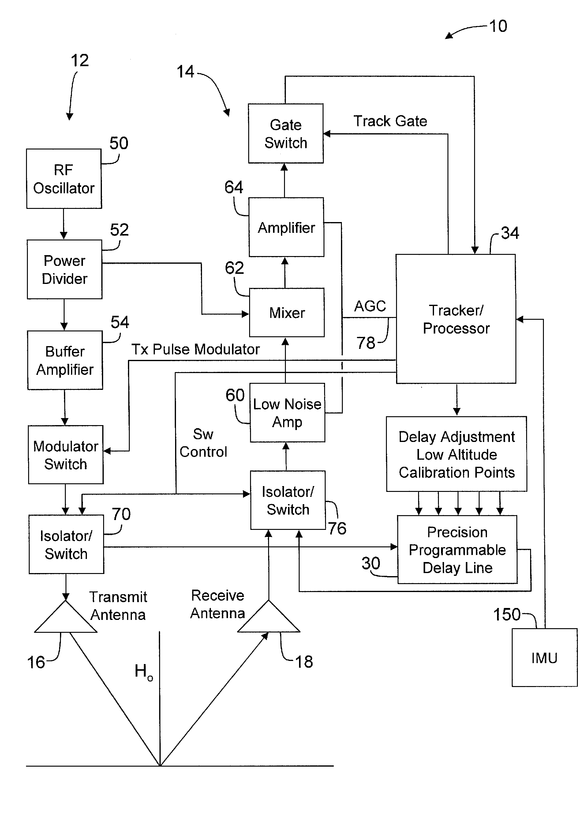
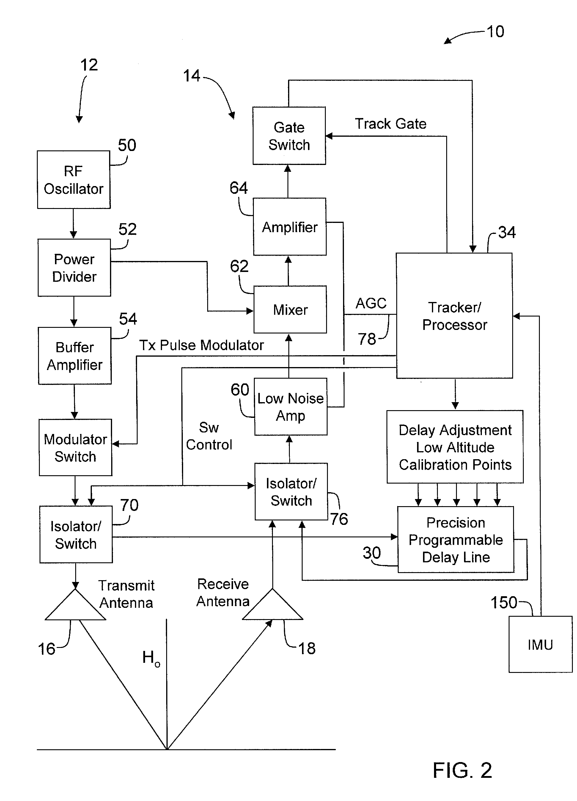
[0020]The present invention provides methods and systems that improve radar altimeter accuracy. In one embodiment, to increase sensor accuracy, a programmable delay device is employed that is configured to automatically provide common mode compensation for any variations or errors in the sensors. To increase ground return signal accuracy, the radar altimeter incorporates additional characteristics which provide compensation as a function of antenna attitude.

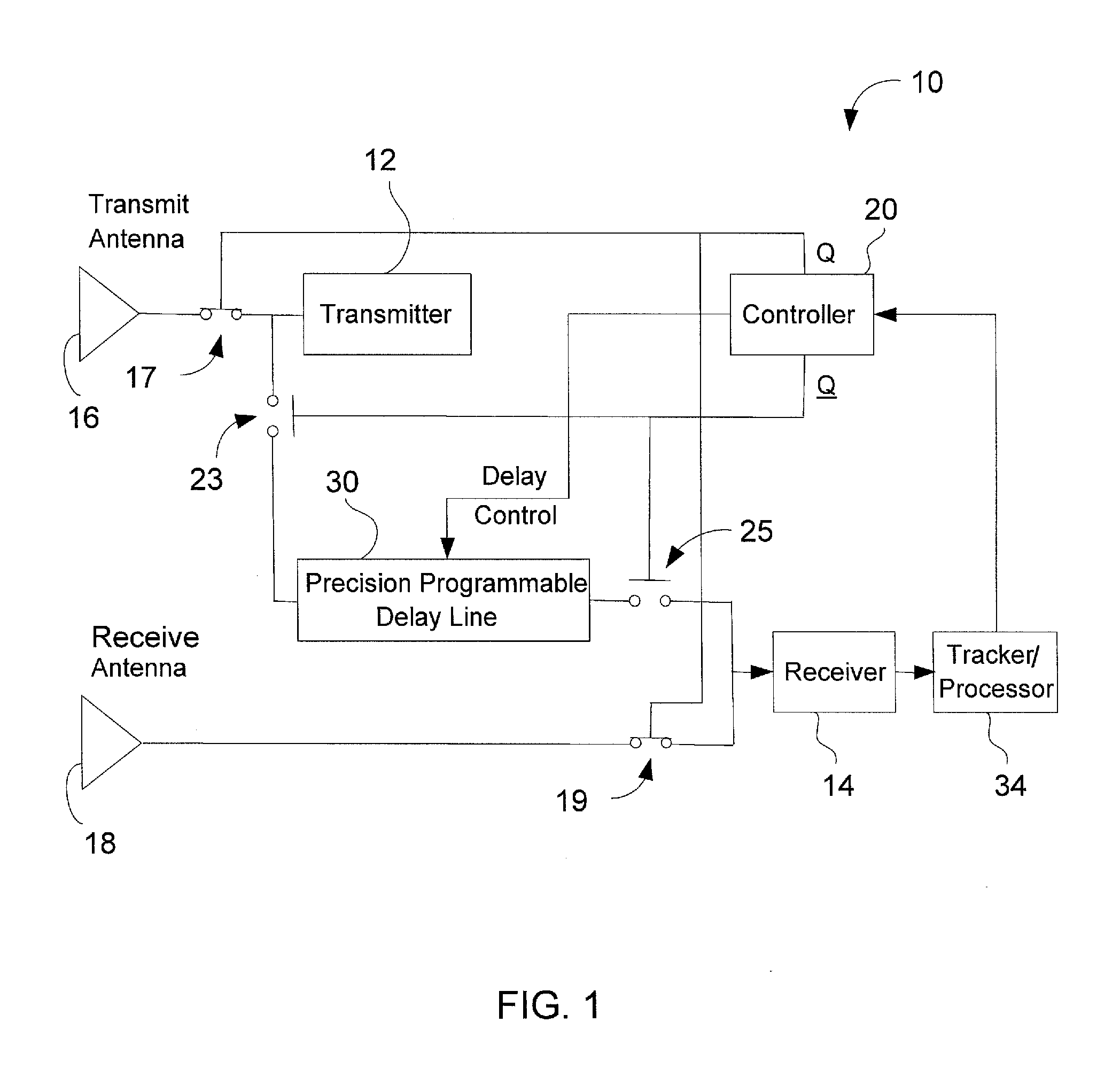
[0021]Referring now to the drawings, FIG. 1 is a block diagram of a radar altimeter 10. Radar altimeter 10 includes a transmitter 12 and a receiver 14. Transmitter 12 is connected to a transmit antenna 16 through a switch 17, and receiver 14 is connected to a receive antenna 18 through a switch 19. A controller 20 controls switches 17, 19, 23, and 25 within radar altimeter 10 and also provides a delay control to a programmable delay device 30 according to instructions from a tracker / processor 34. Tracker / processor 34 receives sig...


PUM


Abstract

A method of compensating for component errors within a radar altimeter is described. The method includes periodically switching transmit pulses from a transmit antenna to a programmable delay device, calculating an altitude based on a transmit pulse received from the programmable delay device, comparing the calculated altitude to an expected altitude, the expected altitude based on a pre-set delay through the programmable delay device, and compensating an altitude measured by the radar altimeter, based on transmit pulses output through the transmit antenna, by an error correction amount based on a difference between the calculated altitude and expected altitudes.

Description

CROSS REFERENCE TO RELATED APPLICATIONS[0001]This application is a divisional of U.S. patent application Ser. No. 11 / 462,901, filed on Aug. 7, 2006 and entitled “HIGH ACCURACY RADAR ALTIMETER USING AUTOMATIC CALIBRATION” (the '901 application). The '901 application is incorporated herein by reference.BACKGROUND OF THE INVENTION[0002]This invention relates generally to radar altimeters, and more specifically, to methods and systems that improve radar altimeter accuracy.[0003]The proper navigation of an aircraft in all phases of its flight is based to a large extent upon the ability to determine accurately the height above terrain over which it is passing, and further based on the ability to determine a position of the aircraft. In this regard, aircraft instrumentation, sensors, radar systems, and specifically, radar altimeters are used in combination with accurate electronic terrain maps. The electronic terrain maps provide the height of objects on the map, and together with the rada...

Claims


Application Information

Patent Timeline
Patent Type & Authority Applications(United States)
IPC IPC(8): G01S13/08
CPCG01S13/882G01S7/4004
Inventor THOMAS, STEVEN H.REILLY, TIMOTHY J.BACKES, GLEN B.
Owner HONEYWELL INT INC
Why Eureka
Try Eureka