Vertical Required Navigation Performance Containment with Radio Altitude

Active Publication Date: 2011-02-10
THE BOEING CO
View PDF15 Cites 24 Cited by
  • Summary
  • Abstract
  • Description
  • Claims
  • Application Information

AI Technical Summary

Benefits of technology

[0012]The invention disclosed herein may enable the use of lower approach decision altitude height limits when using vertical navigation performance-based approaches which use barometric-referenced altimetry. The invention provides a method to positively detect and mitigate common mode failures which could compromise flight safety, such as incorrect barometric settings entered by pilots, incorrect barometric settings provided by ATC, altitude measurement errors due to extreme temperatures, or other common mode failures that can affect barometric systems such as volcanic ash. Currently barometric altimetry-based approaches are limited to a decision height of 250 ft or higher due to obstacles along

Problems solved by technology

Currently barometric altimetry-based approaches are limited to a decisio

Method used


Image

  • Vertical Required Navigation Performance Containment with Radio Altitude
  • Vertical Required Navigation Performance Containment with Radio Altitude
  • Vertical Required Navigation Performance Containment with Radio Altitude

Examples


Embodiment Construction

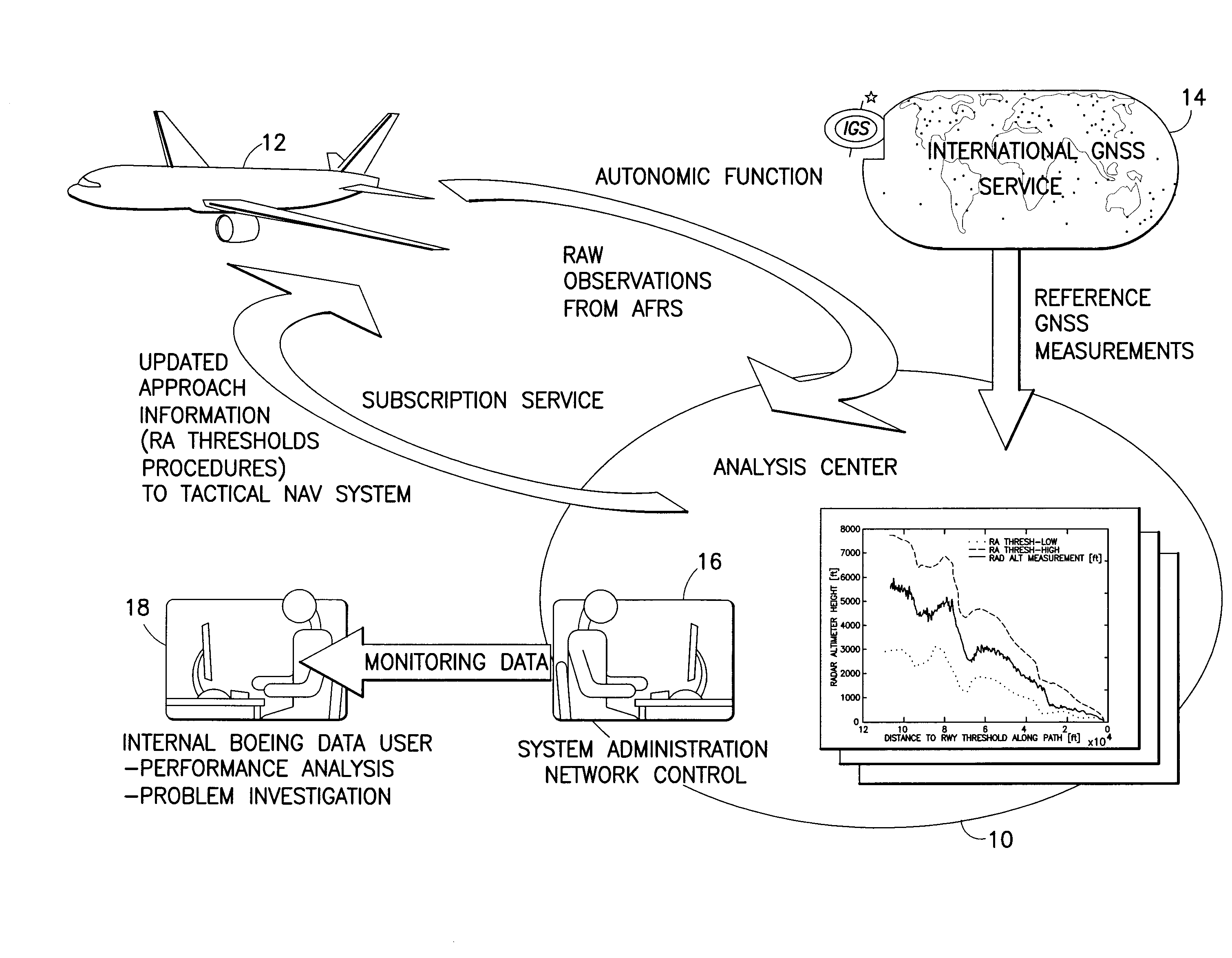
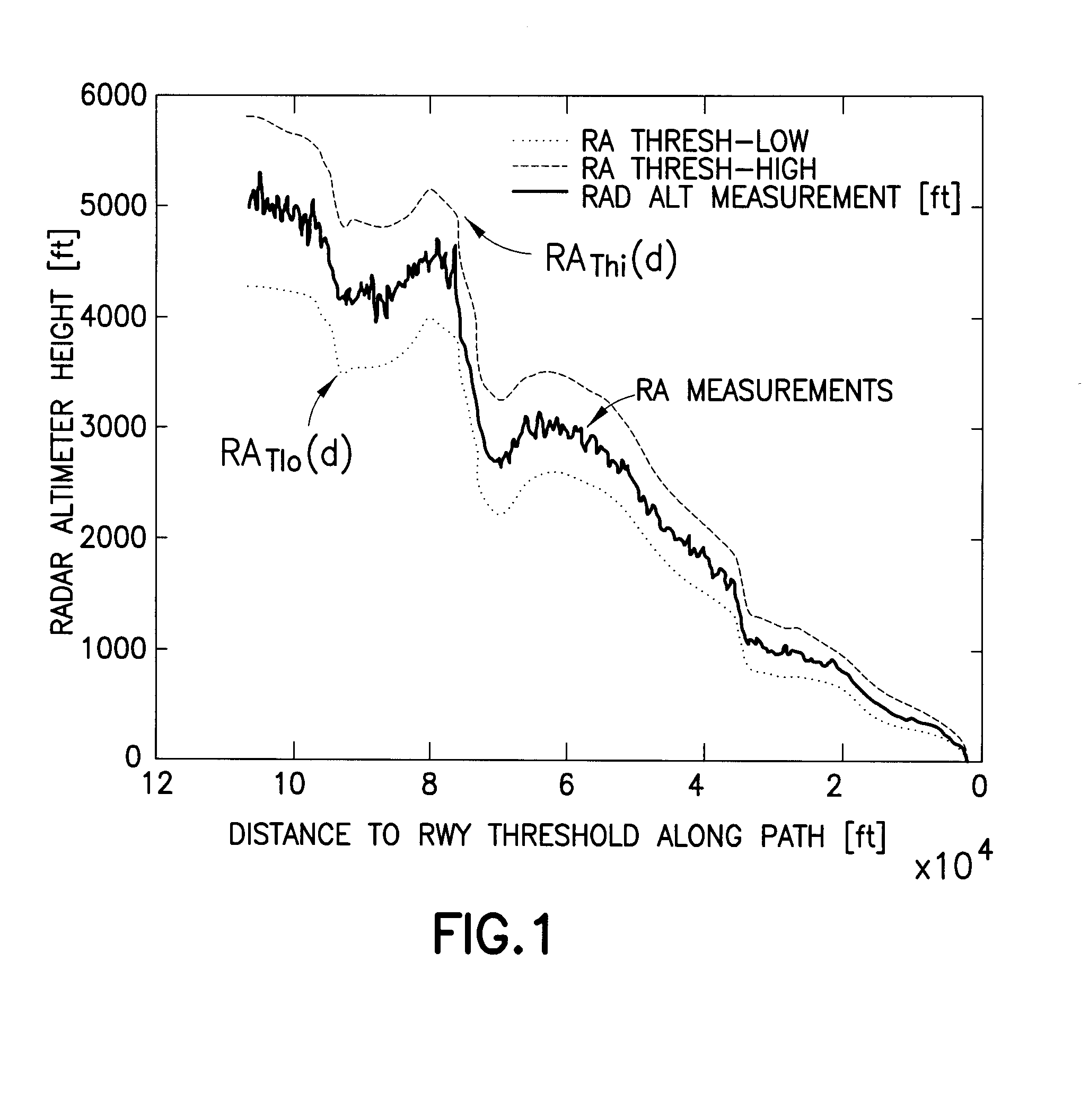
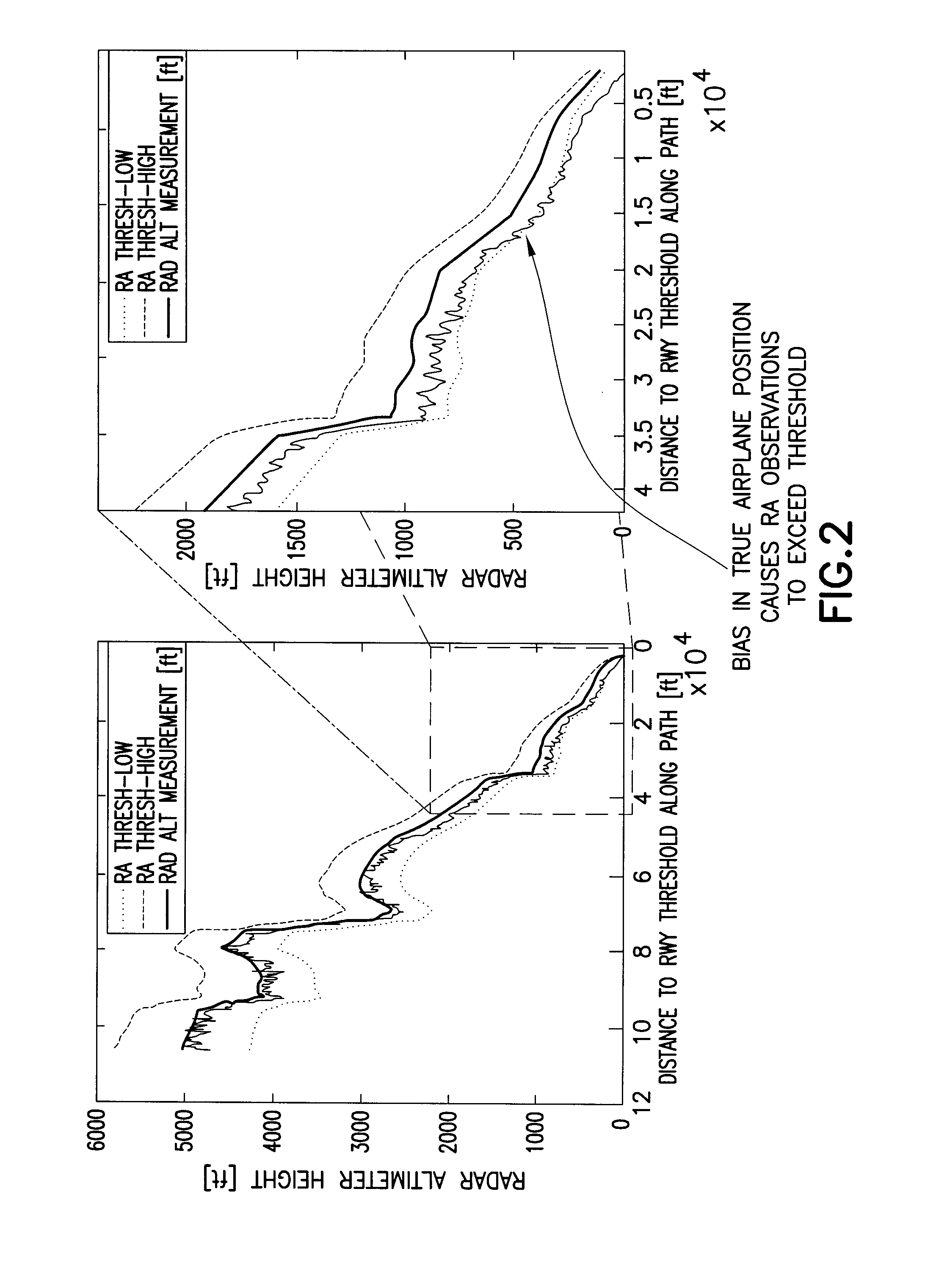
[0027]The following features will be disclosed in detail hereinafter: (1) a monitor for detecting unacceptable deviation of true airplane vertical position from a desired reference path; (2) means for determining the appropriate thresholds for said monitor; (3) a process for developing and maintaining the monitors over time via a so-called “Net Centric Navigation Service”; and (4) a system of using non-tactical GPS and RA measurements of airplane position in a post-processing system to derive the reference path which is the basis for the monitor.

[0028]The solution disclosed hereinafter differs from existing solutions in the following ways:

[0029](1) existing solutions do not monitor total system error through cross comparison based on an independent dissimilar sensor type;

[0030](2) existing solutions typically only allow for bounding or containment of navigation system error;

[0031](3) the present solution addresses (and effectively mitigates) common mode error sources associated with...


PUM


Abstract

A monitor on-board an aircraft which uses radio altitude measurements as the basic observable altitude during runway approach. The basic concept utilizes the aircraft's navigation system, which includes means to store and retrieve radio altitude thresholds as a function of the distance along the desired path from the runway thresholds. These threshold functions are determined in advance based on a radio altitude reference which is defined as the expected radio altimeter measurement that would be made if the airplane were exactly on the desired reference path. Vertical containment monitoring is achieved by comparing the radio altitude measurement to computed thresholds for both too high and too low. During the approach, an annunciation message can be generated if the radio altitude measurement is above or below the threshold limits. Using this monitor ensures that the total system error for the aircraft is contained within a bound called the Vertical Containment Level of the desired reference path in space with a probability that is specified.

Description

BACKGROUND[0001]This invention generally relates to systems for safely guiding the landing of aircraft. In particular, the present invention relates to means for monitoring total system error performance for Vertical Navigation (VNAV) approaches based on baro-altimetry.[0002]Significant time and money has been invested in developing Required Navigation Performance (RNP)-based approaches. These approaches use baro-altimetry as the reference for vertical guidance. These approaches have until the current time been limited to minimum Decision Heights (DH) of 250 ft. In practice, the decision heights are often even higher than this theoretical minimum due to obstacles etc.[0003]The current baro-altimetry-based vertical guidance systems (commonly called baro-VNAV systems) are vulnerable to certain common mode failures which could compromise safety. These include: incorrect barometric corrections settings entered by pilots, incorrect barometric corrections provided by Air Traffic Control (...

Claims


Application Information

Patent Timeline
IPC IPC(8): G06F7/00G06F17/30
CPCG01S7/003G01S13/882G01C23/00G05D1/042B64D45/04G01S19/32G05D1/0676G08G5/0021G08G5/025G01C21/00G01S13/913G05D1/0653
Inventor MURPHY, TIMOTHY ALLEN
Owner THE BOEING CO
Why Eureka
Try Eureka