Earthquake damage prediction and prevention system and method thereof

a technology applied in the field of earthquake damage prediction and prevention system, can solve the problems of not considering the portfolio and its geographical distribution of objects, unable to make scientifically reproducible predictions to a specific hour, day, or month, and the correlation between earthquake impact index and real damage caused to assets is poor, and achieves full transparency

Active Publication Date: 2011-11-03
SWISS REINSURANCE CO LTD
View PDF4 Cites 24 Cited by
  • Summary
  • Abstract
  • Description
  • Claims
  • Application Information

AI Technical Summary

Benefits of technology

[0008]It is an object of this invention to provide a new and better earthquake damage prediction and prevention system and method which does not have the above-mentioned disadvantages of the prior art. In particular, it is an object of the present invention to provide earthquake damage prediction and prevention system and method for predicting the impact or damage caused by an earthquake to objects associated with different geographical locations which generates reliable earthquake impact signals and which can easily be weighted. The generation of the appropriate signals or vales should be time correct well in advance of an occurring earthquake. In the ideal case, the system should be self-adapting during operation. The earthquake impact index or signal should be indicative of the damage or impact caused by an earthquake to a certain object or even to a portfolio of values or objects associated with different geographical locations. In particular, it is an object of the present invention to provide an earthquake damage prediction and prevention system and method for generating impact index signals with consideration of the geographical distribution of the portfolio of values or objects. Furthermore, it is an object of the present invention to provide a earthquake damage prediction and prevention system for generating impact index signals without the need for a technically complex infrastructure having a network of geographically densely distributed seismological measurement stations.
[0011]In an embodiment variant, the system comprises alarm means for generating and transmitting an electrical stimulus pulse to activate automated alarm systems and / or damage intervention devices. This has inter alia the advantages that the present system can be placed in a technical surrounding of self-activating damage intervention devices or systems. Even catastrophic triggered uncertainties or stock exchange fluctuation can be efficiently and actively intercepted through transmitted stimulus signals automatically generated by the system of the present invention. The automated alarm systems can e.g. be accessible and activated by the central unit of the system over the network interface allowing for their state transition triggered by definable threshold values.
[0014]In embodiment variant, the objects are particularly achieved in that, for determining an impact index indicative of the impact or damage caused by an earthquake to a portfolio of values or objects associated with different geographical locations, stored is an equation defined for calculating, for a geographical location, a local earthquake intensity, based on a given distance of the geographical location from a hypocenter of an earthquake, and a given earthquake magnitude of the earthquake. Calculating local intensity values, e.g. local shaking intensity values, makes it possible to estimate a local earthquake impact, without the requirement of seismological measurement stations at the respective geographical location. For example, the geographical locations are defined by coordinates i.e. longitude and latitude values. For the geographical locations, one or more impact ratio tables are stored. The impact ratio tables define in each case impact (or damage) ratios for different earthquake intensity levels. For example, different impact ratio tables are assigned to different geographical locations. Stored is portfolio data, which includes geographical locations and individual weighting factors assigned to the geographical locations. Calculated are geometric distances of the geographical locations from a hypocenter of an earthquake event. For the geographical locations, local intensity values are determined by using in each case the stored equation to calculate the local intensity from the magnitude of the earthquake event and the geometric distance of the respective geographical location from the hypocenter. Subsequently, the impact index is calculated for the geographical locations by determining in each case, from the impact ratio table, the impact (or damage) ratio for the local intensity at the respective geographical location, and adding up the impact (or damage) ratios, weighted in each case by the weighting factor assigned to the respective geographical location.
[0020]The proposed system and method make it possible for anyone to assess the earthquake impact index right after an earthquake event (or for any conceived earthquake) defined only by magnitude, depth and coordinates. The computer program product can be distributed in an electronic format in parallel with other supporting information for the structured financial product. Thus the proposed system and method provide full transparency to investors of a structured financial product based on the impact index by making it possible for the investors to perform on their own pre-and / or post-assessments based on publicly available data.

Problems solved by technology

Despite considerable research and development efforts by engineer and seismologists, scientifically reproducible predictions are difficult to make and cannot yet be made to a specific hour, day, or month.
Defining the earthquake impact index solely on a measured magnitude of the earthquake has the disadvantage that there is no consideration of the portfolio and its geographical distribution of objects.
Consequently, an earthquake impact index based solely on the magnitude of the earthquake correlates poorly with the true damage caused to the assets (objects) included in the portfolio.
Particularly, with an increase of the geographical area in which the geographical locations are distributed, the magnitude based impact index shows an increasingly poor correlation with the true damage.
However, owing to the cost of installation and maintenance, an infrastructure with a network of geographically densely distributed seismological measurement stations is currently not available in the majority of countries.
Many pseudoscientific theories and predictions are made, which scientific practitioners find problematic.
The natural randomness of earthquakes and frequent activity in certain areas can be used to make “predictions” which may generate unwarranted credibility.
However, even if the prediction models are comparatively good, the propagation through different geological structures is difficult to determine and to weight within a certain region.
Such models are difficult to test or validate because large earthquakes are so rare, and because earthquake activity is naturally clustered in space and time.
This method has still no reliable results.
While 50% of major earthquakes are preceded by foreshocks, only about 5-10% of small earthquakes turn out to be foreshocks, leading to many false warnings.
In the state of the art, efficient earthquake damage prediction and prevention systems are technically difficult to realize.
Even within an epicenter region it is often difficult to properly weight the local impact and impact values, respectively, due to different geological formations, gating of the affected object to the ground and internal structure and assembly of the affected object.
Furthermore, earthquake damage prediction and prevention systems of the date of art are not very reliable and often to slow.
One of the problems of the state of the art is, that the signals of the systems can hardly be correctly weight, due to the law of large numbers i.e. of low statistic in the field of earthquakes in connection with a specific geological formation.
Finally, those systems of the state of the art are expensive to realize and extremely costly in terms of labor.

Method used


Image

  • Earthquake damage prediction and prevention system and method thereof
  • Earthquake damage prediction and prevention system and method thereof
  • Earthquake damage prediction and prevention system and method thereof

Examples


Embodiment Construction

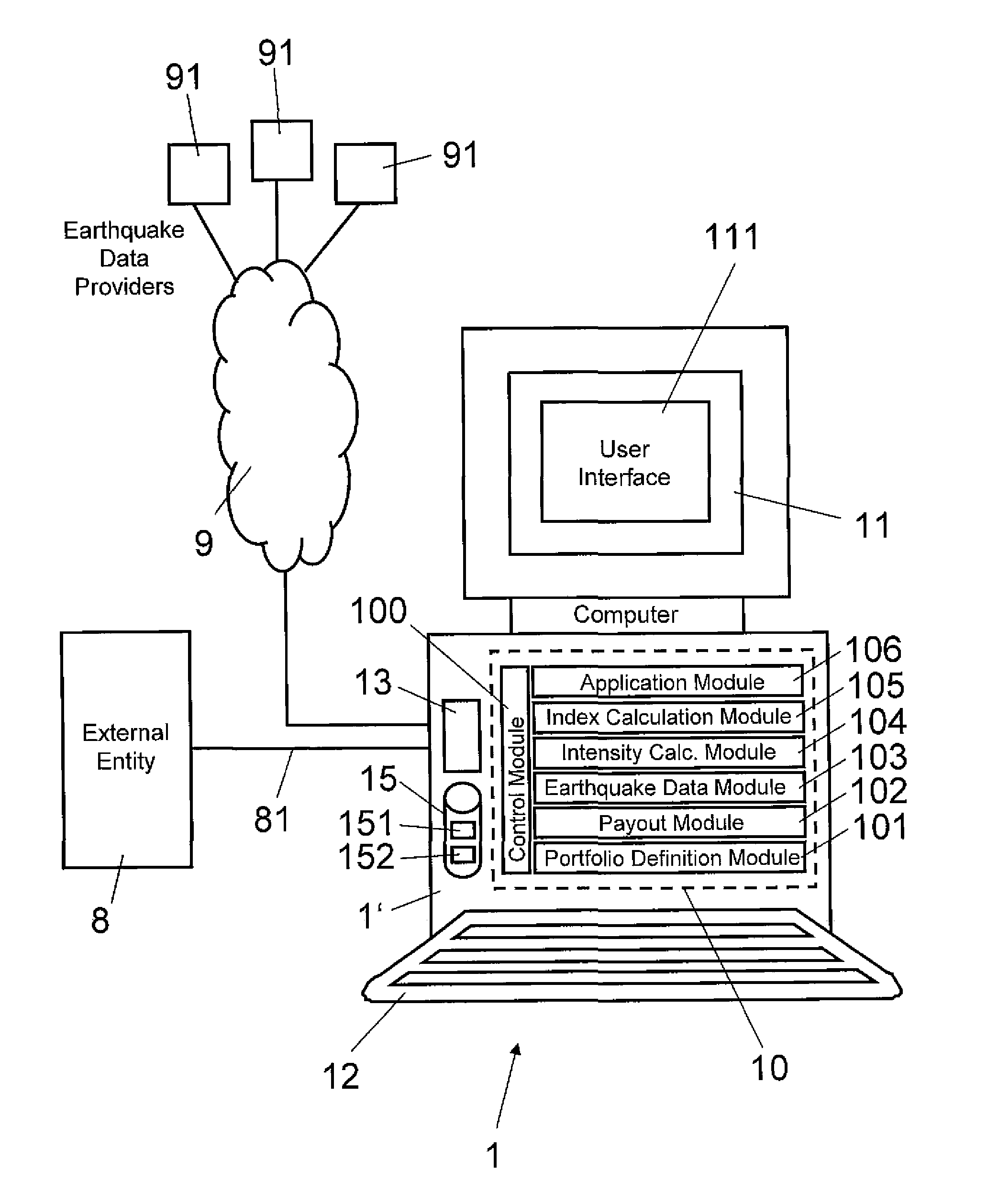
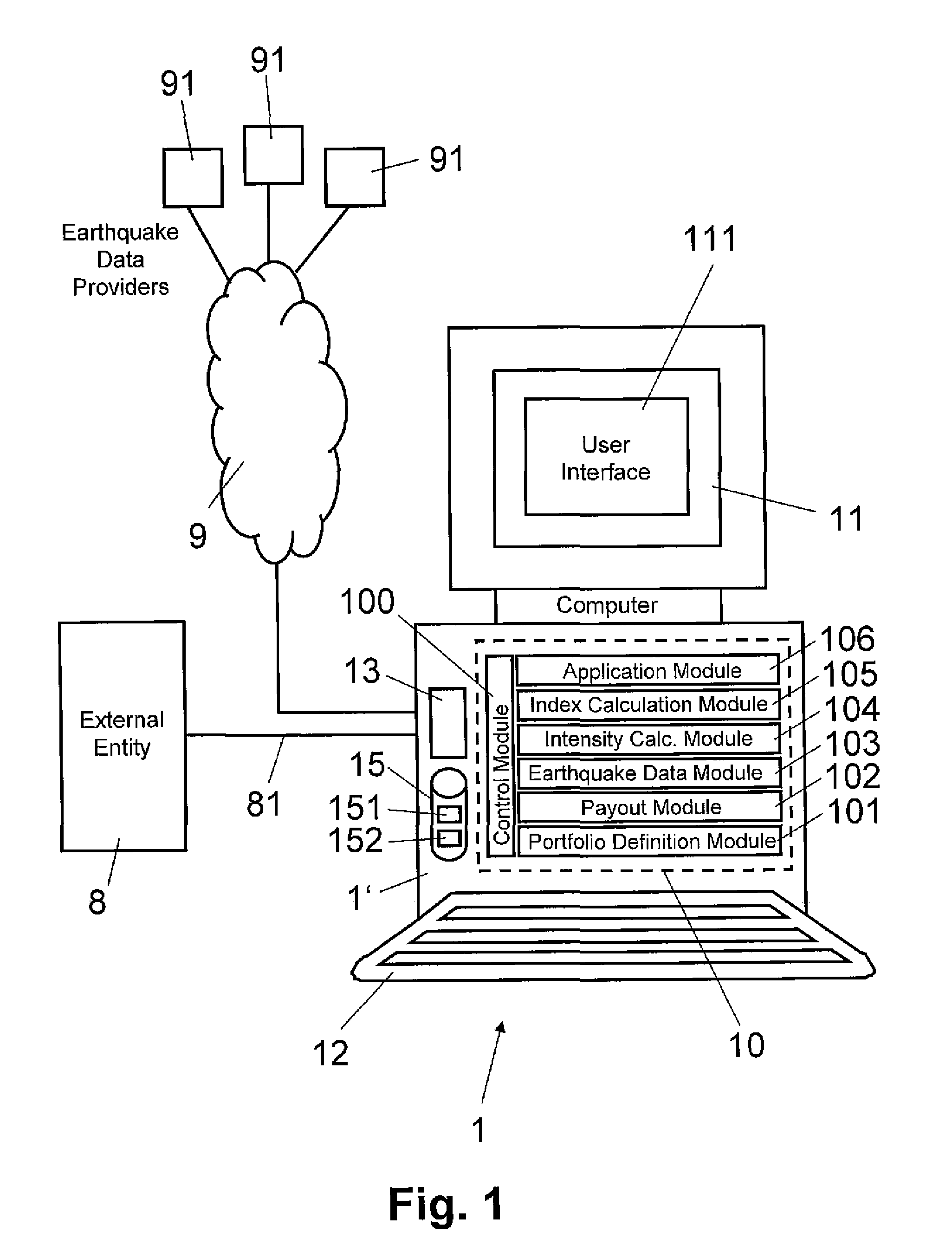
[0027]In FIG. 1, reference numeral 1 refers to an earthquake damage prediction and prevention system for determining an impact index indicative of the impact or damage caused by an earthquake to an object or a portfolio of values or objects associated with geographical locations. For example, the portfolio can relate to objects or values of property or non-property nature, e.g. non-physical values such as business interruptions, contingent business interruption values or exposed population. As is illustrated in FIG. 1, the system 1 includes a processor means 1′ (e.g. a computer), connected to a display 11 and to data entry means 12 such as a keyboard and / or a pointing device. The computer 1′ is provided with one or more processors and is implemented as a personal computer, for example.

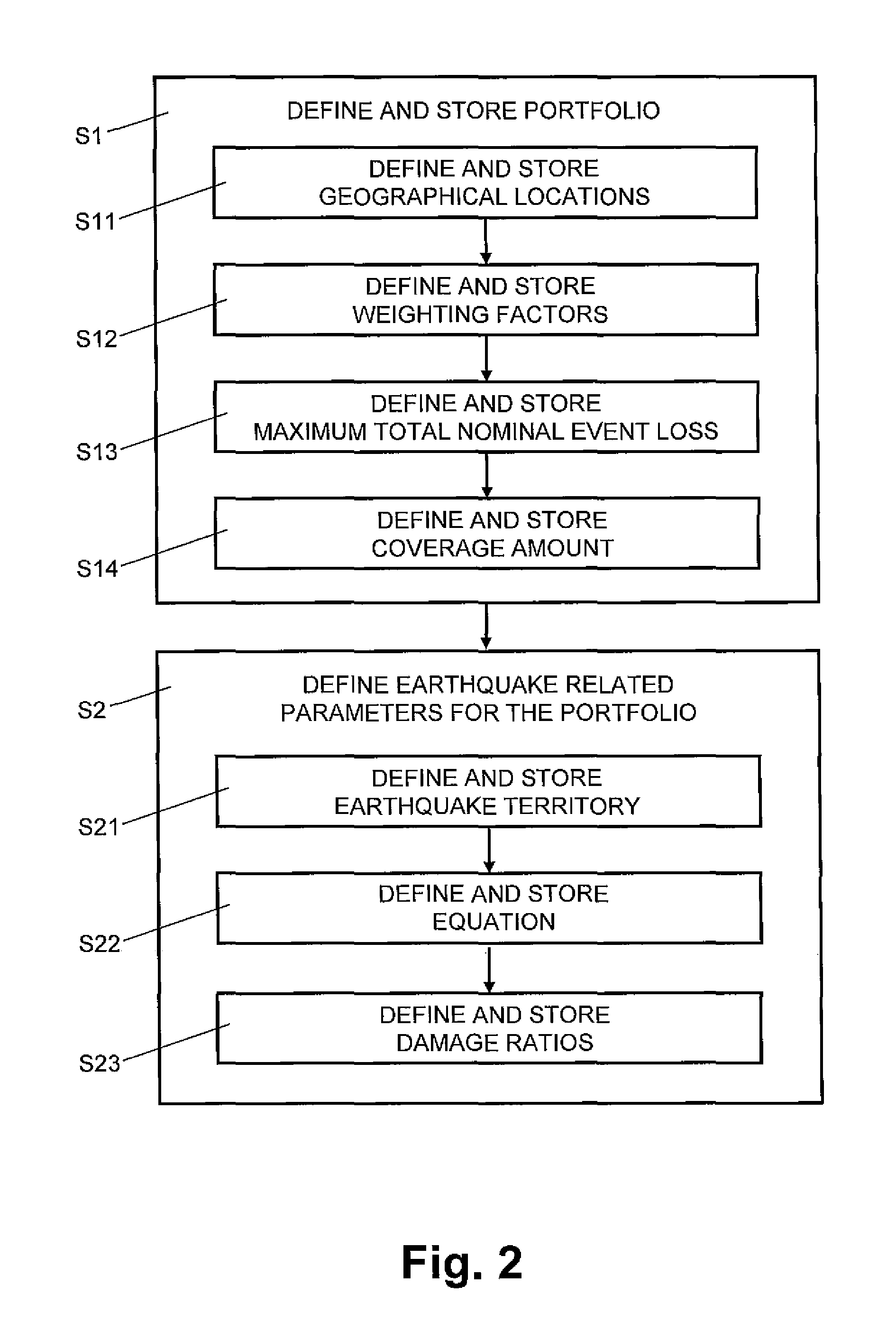
[0028]In FIG. 1, reference numeral 10 refers to functional modules of the earthquake damage prediction and prevention system 1: a control module 100, a portfolio definition module 101, a payout module ...


PUM


Abstract

An earthquake damage prediction and prevention system for determining an impact or damage caused by an earthquake to objects associated with different geographical locations. A central unit with a filter module selects and collects earthquake related data of a plurality of network units. At least one impact ratio table is stored with a first data structure for storing geographical and / or topographical data coordinates of the different geographical locations. The geometric distances of the geographical locations from a hypocenter / epicenter are generated by an intensity calculation module with a coordinates processor. Local intensity values based upon the generated geometric distances and a given earthquake magnitude of a stored parameterization including variable weight parameters are generated by a propagation calculation unit of the intensity calculation module, whereas the generated geometric distances are stored assigned to the corresponding geographical locations by a second data structure of the impact ratio table. At least one of the variable weight parameters and / or at least one impact ratio for different earthquake intensity levels indicative of the impact or damage caused by an earthquake to the object and / or at least one object parameter defining earthquake exposed structures of the object are received from a plurality of users. By an index calculation module the impact index for the geographical locations is generated by determining in each case from the impact ratio table the impact ratio for the local intensity at the respective geographical location, and the impact ratios are added up weighted in each case by the weighting factor assigned to the respective geographical location.

Description

FIELD OF THE INVENTION[0001]The present invention relates to an earthquake damage prediction and prevention system and a method thereof. In Particularly, a impact index parameter indicative of the impact or damage caused by an earthquake is generated by the system whereas activation or alarm signals are generated based on the variable index parameter and transmitted to appropriate alarm and damage prevention or damage intervention devices. Specifically, the present invention relates to a system and a method for determining an impact index indicative of the impact or damage caused by an earthquake to a pre-defined portfolio of objects or values of property or non-property nature, associated with different geographical and / or geological locations.BACKGROUND OF THE INVENTION[0002]In the state of the art, an earthquake prediction system or an earthquake damage prediction system is a system capable of generating prediction that an earthquake of a specific magnitude will occur in a partic...

Claims


Application Information

Patent Timeline
Patent Type & Authority Applications(United States)
IPC IPC(8): G06N5/02G06Q40/00
CPCG06Q40/08G06Q40/06
Inventor BERTOGG, MARTIN
Owner SWISS REINSURANCE CO LTD
Why Eureka
Try Eureka