Virtual Tagging Method and System

a virtual tagging and image technology, applied in special data processing applications, instruments, cathode-ray tube indicators, etc., can solve the problems of inability to overlay acquired images with additional information items, inability to access and interact with location sensitive information,

Inactive Publication Date: 2011-11-17
BITRA LOKESH
View PDF5 Cites 32 Cited by
  • Summary
  • Abstract
  • Description
  • Claims
  • Application Information

AI Technical Summary

Benefits of technology

[0017]The systems and methods according to the present invention let users set up virtual tags like “placeholders”, overlaid over real-world images, providing an intuitive and experience-rich medium for location based information seekers and location sensitive service providers. The present invention also allows anyone with a GPS enabled camera phone to set up a virtual tag.

Problems solved by technology

However, access and interaction with location sensitive information are so far limited to text- or map-based interfaces.
However, the acquired images may not be overlaid with additional information items, such as virtual tags.

Method used


Image

  • Virtual Tagging Method and System
  • Virtual Tagging Method and System
  • Virtual Tagging Method and System

Examples


Embodiment Construction

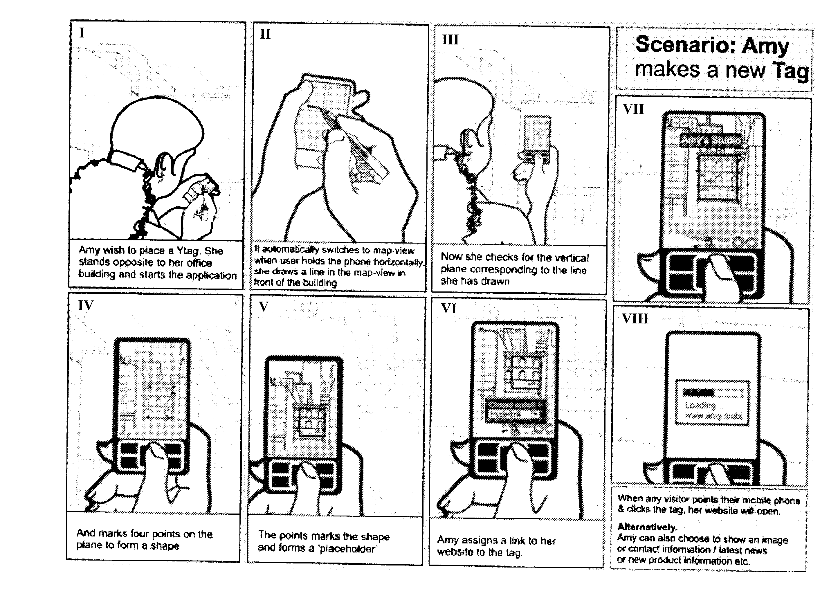
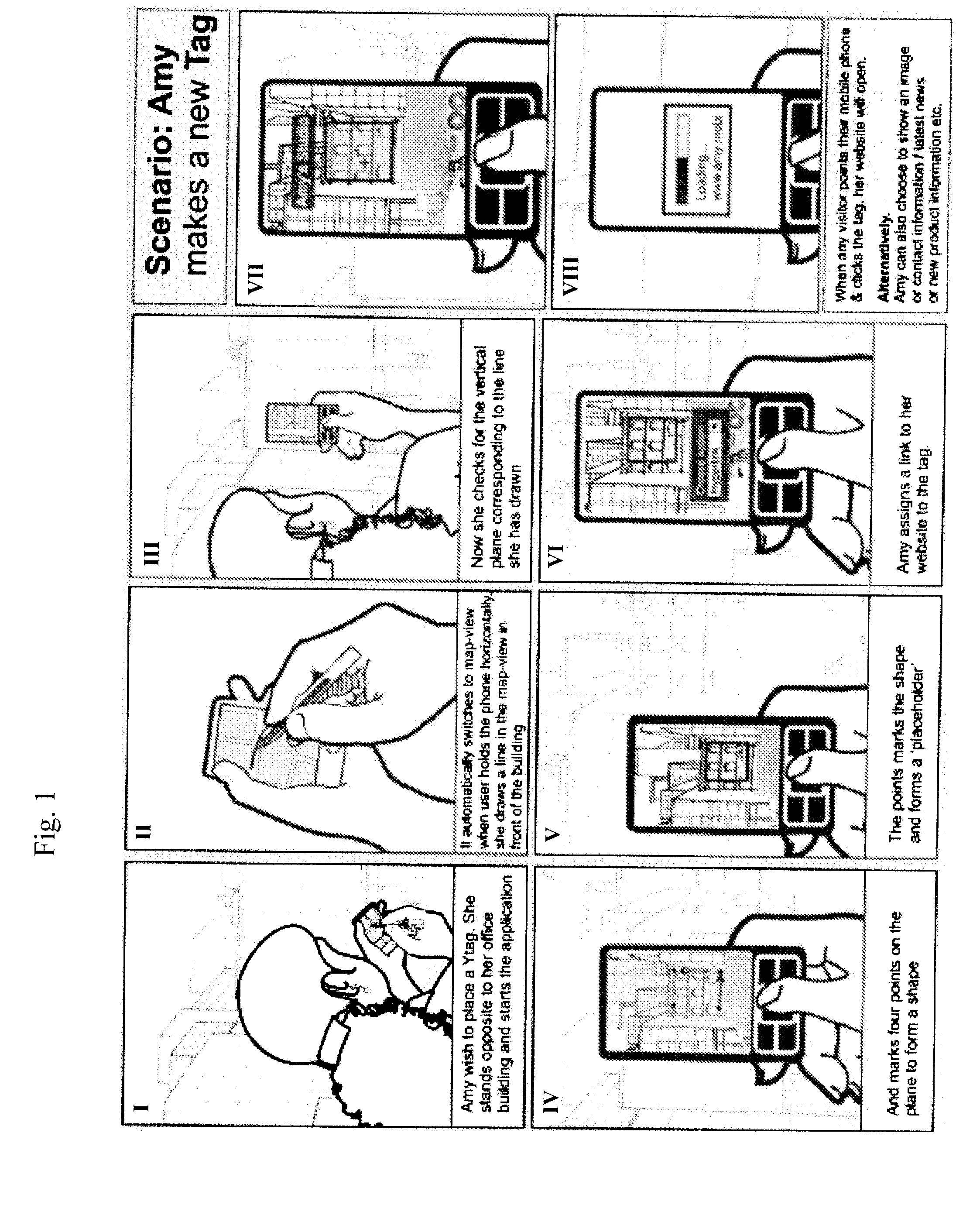
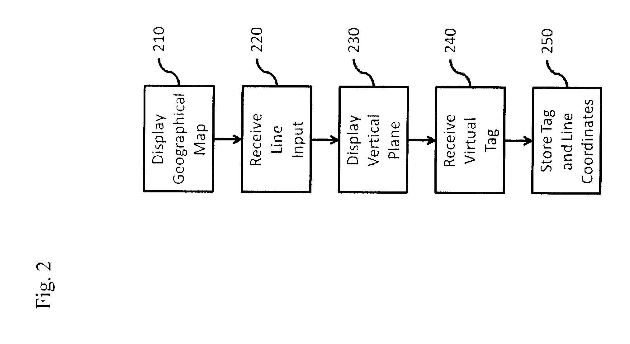
[0019]FIG. 1 shows a usage scenario of a preferred embodiment of the inventive methods and system. The first scenario picture I in the upper left corner shows a user standing opposite of a physical building and wishing to place a virtual tag (“Ytag” or “YT”). In the next picture II, the hand-held device running a method according to the invention automatically switches to map-view when the user holds the phone horizontally. The user may then draw a line in the map-view in front of the building. Holding the phone then vertically in picture III, the user may then check whether a vertical plane drawn by the inventive application corresponds to the line the user has specified. Then, in picture IV, the user marks four points on the plane to form a shape. Shapes may be of any complexity and may also be specified by a user's gestures, using e.g. a touch-sensitive display. In picture V, it is shown how the points mark the shape of a virtual tag, forming a ‘placeholder’ for additional inform...


PUM


Abstract

A method for associating a virtual tag with a geographical location, comprising the steps of displaying (210) a two-dimensional geographical map; receiving (220) inputs specifying a line on the map; displaying (230) a vertical plane passing through the line, perpendicular to the map; receiving (240) information specifying a position of a virtual tag on the displayed vertical plane; and storing (250) the name and position of the virtual tag and the coordinates of the line on the map in a database.

Description

[0001]The present invention relates to a hand-held augmented reality (AR) system and method wherein a live direct or indirect view of a physical real-world environment is merged with or augmented by virtual computer-generated imagery in real time and / or in real location, or in a remote desktop in a simulated or virtual environment.TECHNICAL BACKGROUND AND PRIOR ART[0002]Today, many portable or hand-held communication devices are equipped with geographical position sensors and provide access to the Internet. Location awareness is generally seen as a key for many next generation services. However, access and interaction with location sensitive information are so far limited to text- or map-based interfaces. Although these interfaces provide hyperlinks, they are still very removed from the way humans naturally act when referring to a geographical location, namely by just looking or pointing at it.[0003]US 2006 / 0164382 A1 discloses a mobile phone device comprising a screen display. A us...

Claims


Application Information

Patent Timeline
Patent Type & Authority Applications(United States)
IPC IPC(8): G09G5/00
CPCG06F17/30241G06F16/29
Inventor BITRA, LOKESH
Owner BITRA LOKESH
Why Eureka
Try Eureka