Coded marker navigation system and method

Active Publication Date: 2012-08-02
RAYTHEON CO
View PDF18 Cites 56 Cited by
  • Summary
  • Abstract
  • Description
  • Claims
  • Application Information

AI Technical Summary

Benefits of technology

[0006]In one example, obtaining an image of a scene further comprises obtaining the image using a 360 degree camera. In one example, the coded marker(s) include barcode(s). In another example, determining a position fix on the location of the navigator further comprises obtaining location information of the navigator using a GPS unit, and in a GPS denied environment, supplementing the location information from the GPS unit with the position fix obtained from at least one coded marker. Determining a position fix on the location of

Problems solved by technology

However, in certain environments, GPS systems suffer from limited availability of the GPS signals and fail to work as well as may be desired.
For example, in an urban environment, tall buildings may obstruct or degrade GPS satellite reception.
Obstruction or degradation of GPS reception because of limited view of the open sky, or because of signal multipath or reflection, may create a “GPS denied” environment in which the GPS receiver is unable to obtain a location fix from the GPS satellite.
There have been several attempts to address the sporadic loss of a GPS signal; however, the

Method used


Image

  • Coded marker navigation system and method
  • Coded marker navigation system and method
  • Coded marker navigation system and method

Examples


Embodiment Construction

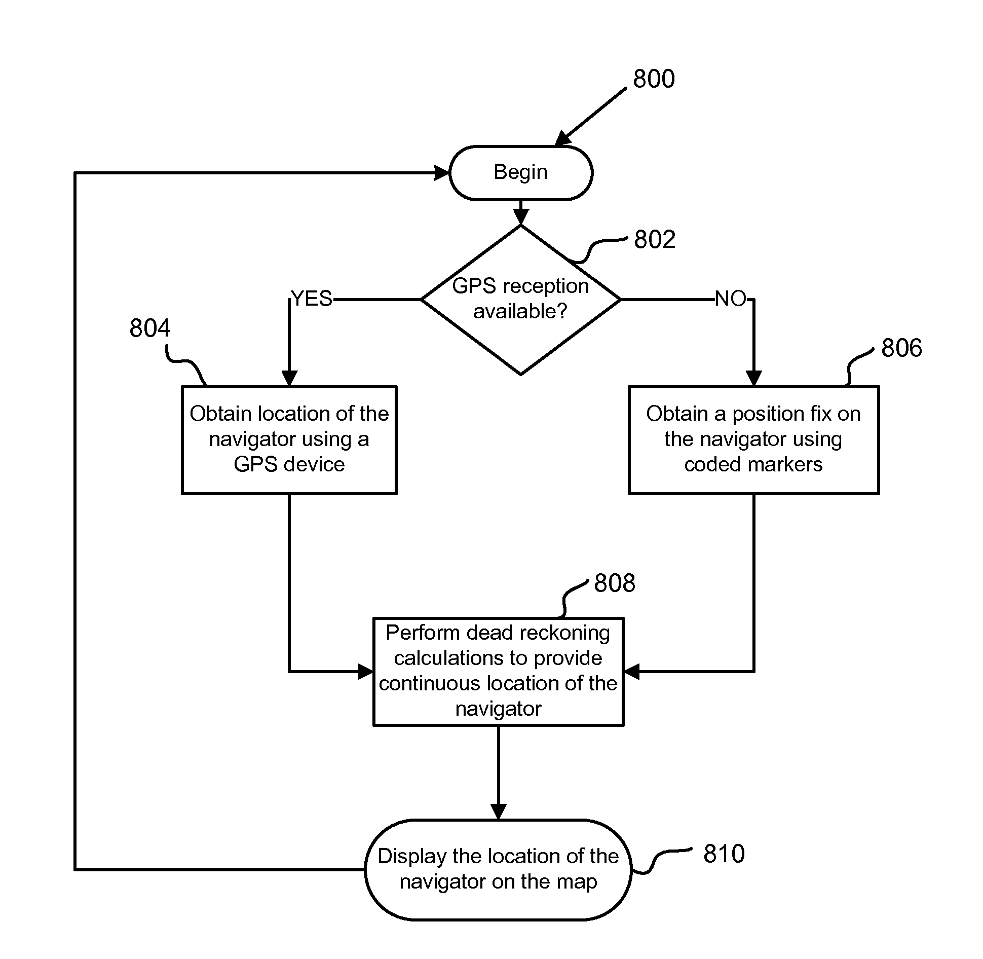
[0022]As discussed above, conventional solutions for obtaining location information of a navigator in “GPS denied” environments suffer from several disadvantages, such as being computationally expensive and / or lacking accuracy and / or adaptability. As used herein, the term “navigator” may refer to a vehicle, a person or any object traveling within a navigation environment. Accordingly, there is a need for a way to navigate in these environments by providing continuous and accurate location information of the navigator without the use of complex systems. Aspects and embodiments are directed to a system and method of navigation that overcomes the limitations and drawbacks of conventional solutions, while providing a solution that is functionally uncomplicated and easy to implement.

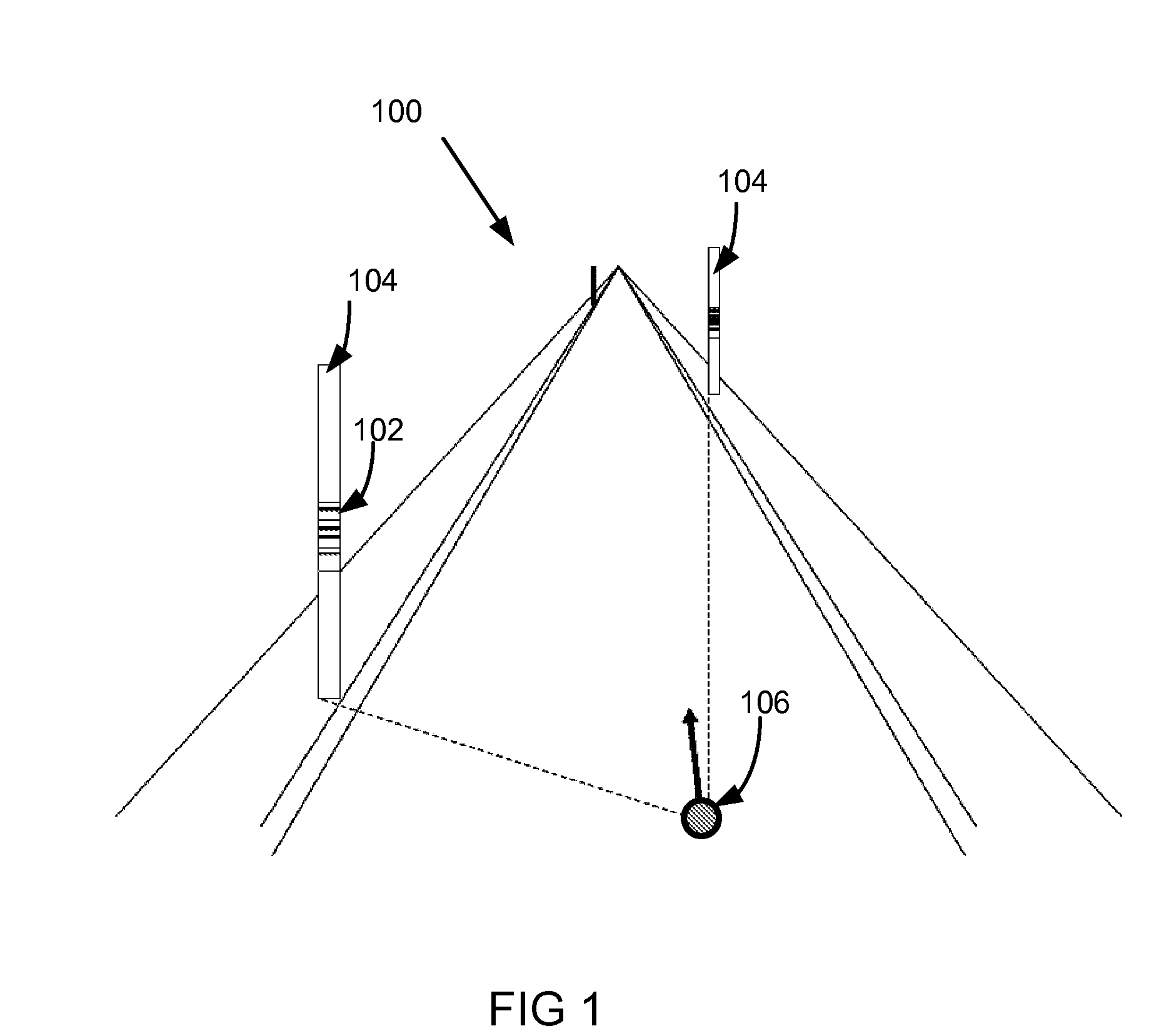
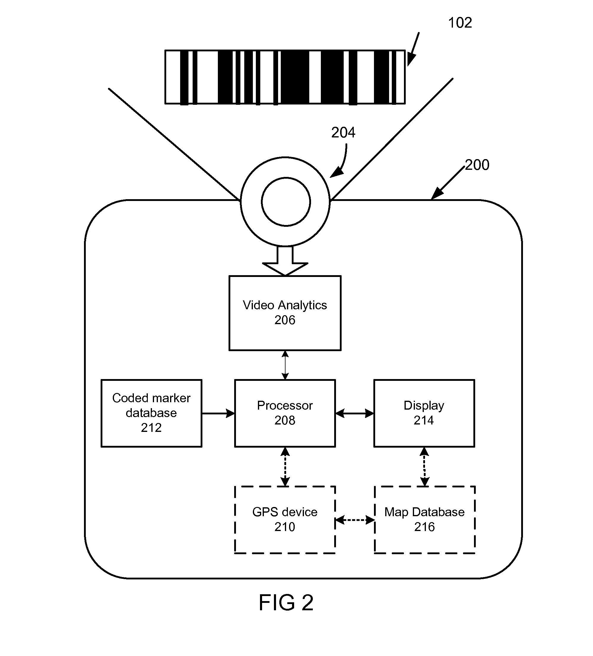
[0023]According to one embodiment a navigation system uses coded markers located within the navigation environment to provide position fixes. These coded markers may be placed on already-present infrastructur...


PUM


Abstract

A navigation system and method for determining a location of a navigator in a navigation environment using coded markers located within the navigation environment. In one example, the navigation system includes a camera apparatus configured to obtain an image of a scene containing images of at least one coded marker in a navigation environment, video analytics configured to read the at least one coded marker, and a processor coupled to the video analytics and configured to determine a position fix of a navigator based on a known location of the at least one coded marker.

Description

BACKGROUND[0001]A well known example of a navigation system is the global positioning system (GPS) satellite-based system which uses a GPS receiver to receive location fixes from the GPS satellites to determine the location of the navigator within a navigation environment. The GPS receiver periodically receives information from broadcasting GPS satellites and uses that information to triangulate the position of the navigator. However, in certain environments, GPS systems suffer from limited availability of the GPS signals and fail to work as well as may be desired. For example, in an urban environment, tall buildings may obstruct or degrade GPS satellite reception. Obstruction or degradation of GPS reception because of limited view of the open sky, or because of signal multipath or reflection, may create a “GPS denied” environment in which the GPS receiver is unable to obtain a location fix from the GPS satellite.[0002]There have been several attempts to address the sporadic loss of...

Claims


Application Information

Patent Timeline
IPC IPC(8): G01C21/00G01C21/12
CPCG01C21/3647G01C21/20
Inventor RICHARDSON, JAMES JOSEPH
Owner RAYTHEON CO
Why Eureka
Try Eureka