Visual Localization Method

a visual and localization technology, applied in the field of visual localization methods, can solve the problems of limiting the applicability of the method to outdoor scenarios with few obstacles, more severe, and virtually inaccessible gps

Active Publication Date: 2013-10-31
NAVVIS
View PDF6 Cites 32 Cited by
  • Summary
  • Abstract
  • Description
  • Claims
  • Application Information

AI Technical Summary

Problems solved by technology

While satellite navigation systems can provide sufficient positioning accuracy, a clear view to at least four satellites is required, limiting its applicability to outdoor scenarios with few obstacles.
Unfortunately, most interesting LBS could be provided in densely populated environments, which include urban canyons and indoor scenarios.
Problems may be caused by multipath effects, which are even more severe if the user is traveling on the sidewalks and not in the middle of the street.
As GPS is virtually not available in indoor environments and the localization accuracy in urban canyons is insufficient, alternative positioning mechanisms, which can complement the available systems, are required.
The main challenge for visual localization is to rapidly and accurately search for images related to the current recording in a large georeferenced database.
The application of CBIR to location recognition complicates these requirements.
For instance, Street View panoramas are available online with varying inter-panorama distances, typically in the range of 12 to 17 m. However, there are problems associated with wide baselines.
Whereas distant buildings can be well associated among the views, close objects like the train station or the tree are difficult to match even for a human observer.
The description of distinct objects is complicated due to the three-dimensional structure of the environment and the resulting occlusions and overlaps.
Further, different lighting conditions between the query and database im...

Method used


Image

  • Visual Localization Method
  • Visual Localization Method
  • Visual Localization Method

Examples


Embodiment Construction

[0020]Bag-of-Features Approach

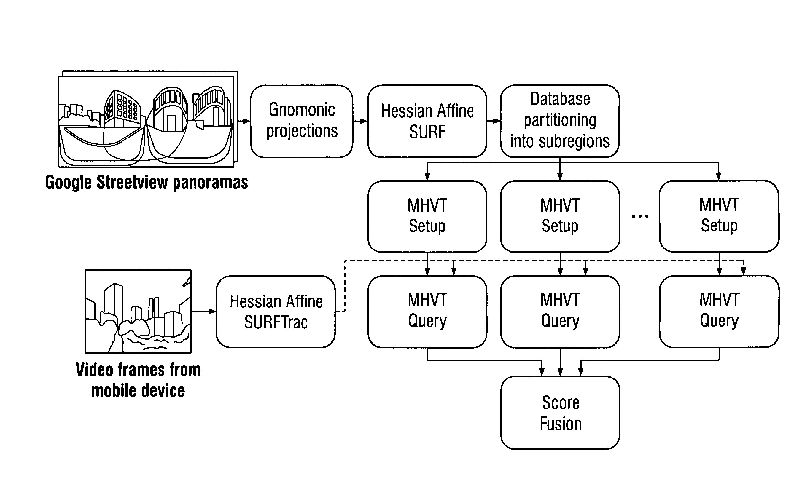
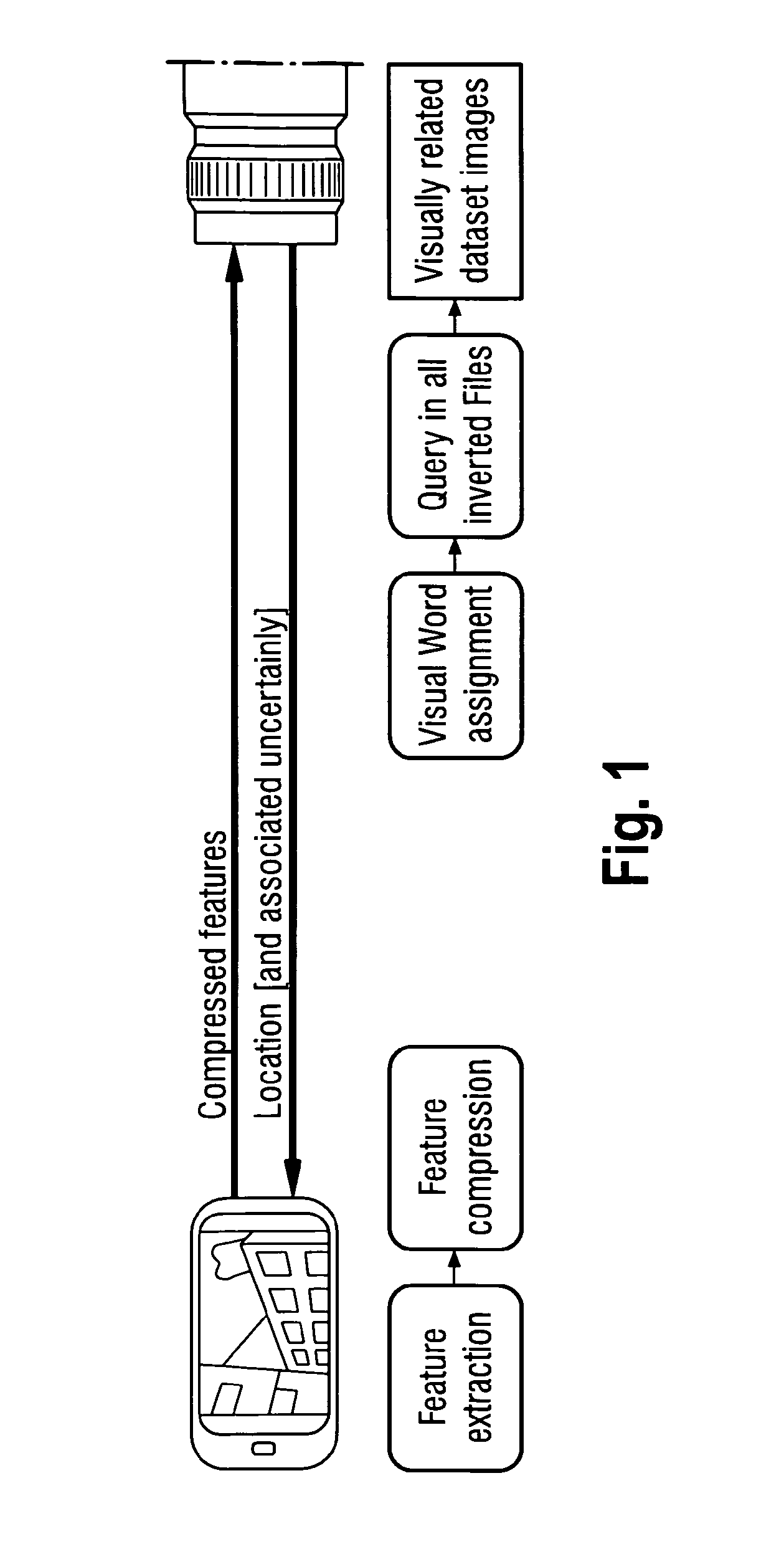
[0021]FIG. 1 illustrates a basic architecture of a visual location recognition system which is in principle similar to that of a mobile visual product search system, with the difference that not a single image but a continuous sequence of images is used to query a reference database. As a first step, robust local features are extracted from the individual video frames to distinctively describe their content. Once the features are extracted, they are sent to the server where content based image retrieval algorithms (CBIR) are employed to identify the visually most similar reference image in the database.

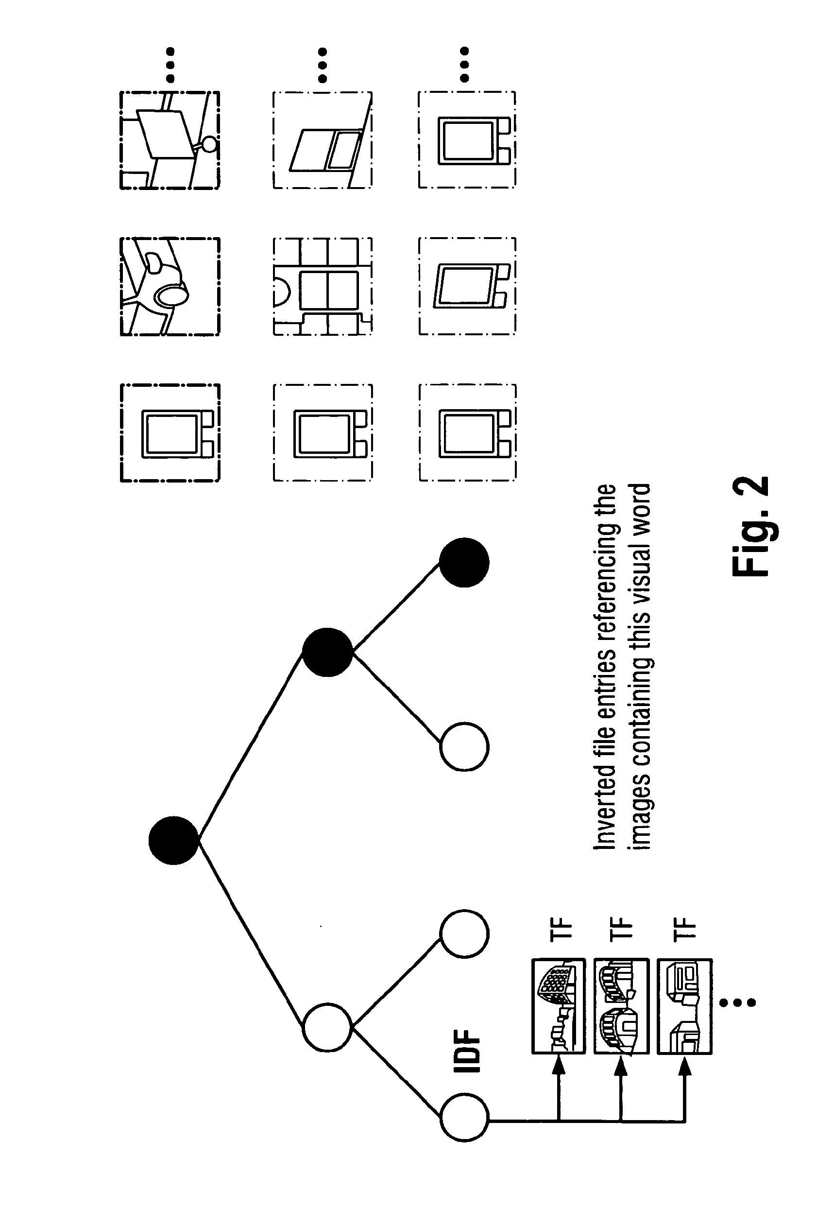
[0022]One approach to this is the Bag-of-Feature (BoF) approach as illustrated in FIG. 2. The BoF approach reformulates the image retrieval problem into a text retrieval problem by quantizing the high-dimensional feature descriptors into so called visual words with the aid of the k-means algorithm. At fine quantization, descriptors associated to a word fo...


PUM


Abstract

There is provided a visual localization method comprising: (a) transmitting data representative of one or more detected visual features from a mobile device to a server; (b) estimating the location of the mobile device at the server based on the visual features 5 received from the mobile device; (c) transmitting reference data associated with the estimated location from the server to the mobile device; and (d) the mobile device determining its location based on the reference data received from the server.

Description

BACKGROUND[0001]Information about the location, orientation, and context of a mobile device is of central importance for future multimedia applications and location-based services (LBS). With the widespread adoption of modern camera phones, including powerful processors, inertial measurement units, compass, and assisted GPS receivers, the variety of location and context-based services has significantly increased over the last years. These include, for instance, the search for points of interest in the vicinity, geo tagging and retrieval of user generated media, targeted advertising, navigation systems, social applications etc.[0002]While satellite navigation systems can provide sufficient positioning accuracy, a clear view to at least four satellites is required, limiting its applicability to outdoor scenarios with few obstacles. Unfortunately, most interesting LBS could be provided in densely populated environments, which include urban canyons and indoor scenarios. Problems may be ...

Claims


Application Information

Patent Timeline
IPC IPC(8): H04W4/02
CPCH04W4/025G06F16/5854G06F16/29G06F16/51G06F16/583G06Q30/0623G06F16/9537G06F18/22
Inventor ABU-ALQUMSAN, MOHAMMADAL-NUAIMI, ANASHUITL, ROBERTSCHROTH, GEORGSCHWEIGER, FLORIANSTEINBACH, ECKEHARD
Owner NAVVIS
Why Eureka
Try Eureka