Incremental network generation providing seamless network of large geographical areas

a network generation and geographical area technology, applied in the field of digital maps, can solve the problems of inability to accurately portray current conditions, inability to generate, extend, revise digital maps, and incomplete existing roadway maps or networks, so as to efficiently generate and update the network, avoid errors associated with seaming steps, and save resources

Inactive Publication Date: 2014-02-13
TOMTOM GERMANY
View PDF4 Cites 5 Cited by
  • Summary
  • Abstract
  • Description
  • Claims
  • Application Information

AI Technical Summary

Benefits of technology

[0012]The plurality of threads each employ entire threads extending across the entire geographical area and cooperatively generate, extend, and revise the network of the large geographical area. Therefore, seaming of individual tiles of the geographical area is not needed, and the errors associated with the seaming steps are avoided. By using multiple threads to simultaneously employ the traces extending across the geographical area, the inventive system and method can efficiently generate and update the network of the large geographical area, such as a country or the world. The inventive system and method provide a quick, reliable, and cost effective way to generate and update digital maps of large geographical areas.
[0013]It will be appreciated that the present invention utilizes multithreading in the generation and updating of digital maps. Multithreading in general is a method of parallelized computing, e.g. in which one program uses different threads (also referred to herein as “processing threads”) in order to compute different things at the same time. The several threads run independently of each other but they can share resources and exchange data. It is common to use multiple threads on multiprocessor systems, e.g. computer systems that have m

Problems solved by technology

As will be appreciated by reference to these figures, in combination with the expense and effort required to produce digital maps, it may be the case that an existing roadway map or network is incomplete in its depiction of all roadways or paths within a given region.
Furthermore, due to the evolving nature of networks which may include but are not limited to roadways and paths, changes may occur over time such that an existing digital map may no longer accurately portray current conditions.
Digital maps are expensive to generate, extend, and revise, since exhibiting and processing road information is very costly.
However, for larger geographical areas, such as an entire country or world, the map generation s

Method used


Image

  • Incremental network generation providing seamless network of large geographical areas
  • Incremental network generation providing seamless network of large geographical areas
  • Incremental network generation providing seamless network of large geographical areas

Examples


Embodiment Construction

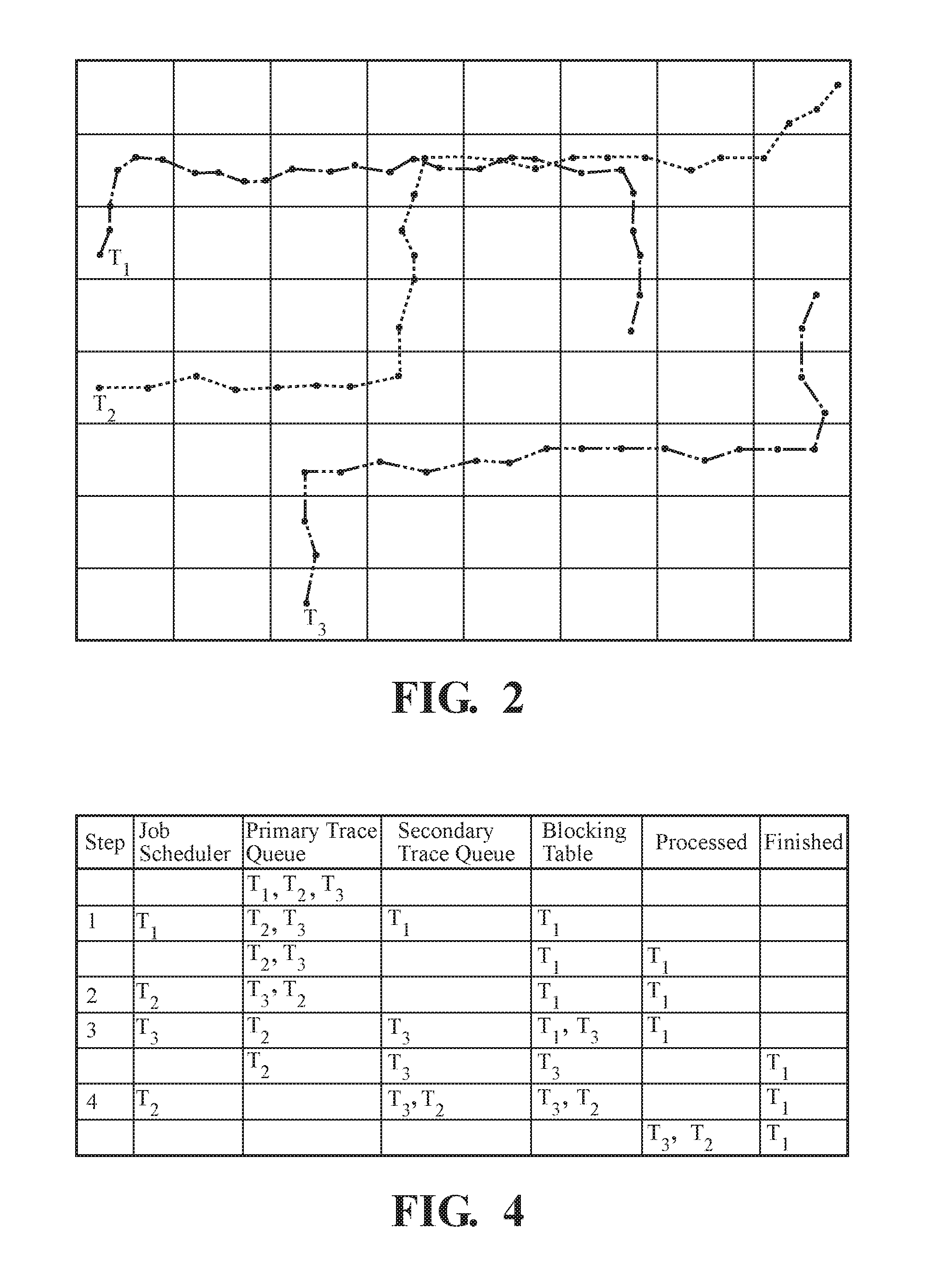
[0019]Referring to the Figures, a system and method for generating a seamless network, such as a road network, of a geographical area for use in a digital map is generally shown. A plurality of probe traces, preferably GPS traces from probe data, extend across the geographical area, and a plurality of threads employ the probe traces. Each of the threads can employ one of the traces while another one of the treads employs another one of the traces to cooperatively generate a single seamless network of the geographical area.

[0020]Each probe trace is a sequence of position data. The problem trace typically includes a timestamp and may also include additional data, such as speed, acceleration, heading, accuracy, etc. The probe trace typically represents the movement of an automotive vehicle, bicycle, pedestrian, or another moving object. The position data can be represented by a two or three dimension coordinate system. The timestamp can be represented in an implicit way or can be omitt...


PUM


Abstract

A system and method for generating a seamless road network of a large geographical area includes a plurality of GPS traces extending across a geographical area. A plurality of threads simultaneously employ entire traces to collectively generate the seamless road network. The method includes dividing the geographical area into tiles, with each trace extending across several tiles. Each thread can employ one of the traces while another thread employs another trace. Each thread employs an entire one of the traces extending across several tiles during a single step. A job scheduler and blocking table prevent threads from simultaneously processing traces having common tiles and disturbing one another. The threads employ an incremental map matching method, wherein the probe traces are compared to existing line segments of the digital map, and new line segments are created using the probe traces not matching the existing line segments.

Description

COPYRIGHT NOTICE[0001]A portion of the disclosure of this patent document contains material which is subject to copyright protection. The copyright owner has no objection to the facsimile reproduction by anyone of the patent document or the patent disclosure, as it appears in the Patent and Trademark Office patent file or records, but otherwise reserves all copyright rights whatsoever.BACKGROUND OF THE INVENTION[0002]1. Field of the Invention[0003]This invention relates to digital maps of the type for displaying networks of roads and other features of geographical areas, and more specifically, toward a system and method for generating, extending, and revising networks of large geographical areas.[0004]2. Related Art[0005]Navigation systems, electronic or digital maps, and geographical positioning devices are increasingly used by travelers to assist with various navigation functions, such as to determine the overall position and orientation of the traveler and / or vehicle, find destin...

Claims


Application Information

Patent Timeline
IPC IPC(8): G01C21/26G06K9/00
CPCG06K9/00791G01C21/26G09B29/106G01C21/3881G01C21/3815G01C21/3841G06V20/56
Inventor MUND, HEIKOSCHARMANN, HANNES
Owner TOMTOM GERMANY
Why Eureka
Try Eureka