Meteorological Modelling Method for Calculating an Aircraft Flight Plan

a meteorological modelling and flight plan technology, applied in the direction of instruments, process and machine control, navigation instruments, etc., can solve the problems of unsuitability, and affecting the accuracy of forecasting

Inactive Publication Date: 2014-07-17
THALES SA
View PDF5 Cites 2 Cited by
  • Summary
  • Abstract
  • Description
  • Claims
  • Application Information

AI Technical Summary

Benefits of technology

[0018]A characteristic making it possible to reduce the calculation times of the modelling method and to increase the precision of the flight plan prediction data is that the navigation management system selects prediction data related to waypoints whose distance of deviation from the nominal route of the flight plan is less than a distance threshold.
[0021]Advantageously, for the meteorological method of flight plan modelling, the current route of the aircraft is an alternative route to the nominal route. The invention makes it possible to recalculate a wind profile for an alternative route of the flight plan. The system having previously loaded wind data for the waypoints surrounding the nominal route, when the navigation management system computes a new flight plan for an alternative route, it uses as input data the wind data existing in the system for these new waypoints if they exist, though it is very improbable that they will have been loaded previously, and / or the wind data for the surrounding points.
[0023]Another advantage is the possibility of defining a more precise wind profile sampling increment, since the invention makes it possible to allocate a wind prediction datum for every waypoint of the flight plan. By computing a flight plan route with numerous waypoints, the navigation system consequently has available to it a wind profile comprising a larger number of data samples.
[0024]Another advantage is that the invention does not require any additional ground structure providing for example a service of 3D meshing of the airspace an as to allocate a wind datum to every waypoint of the flight space surrounding the nominal route. Moreover, the aircraft is also not constrained to have specific onboard equipment, the modelling method possibly being carried out by the existing navigation management system and the wind data necessary for the calculation may also be recovered by the existing communication management system.
[0027]The invention also relates to the navigation management system for an aircraft making it possible to calculate a flight plan between the departure airport and the arrival airport. The system is characterized in that to compute the flight plan prediction data, the said system carries out the meteorological modelling method such as described in any mode of realization above.

Problems solved by technology

Meteorological uncertainties are the main causes of time related vagaries when calculating flight plans.
These data which constitute the predictive snapshot are, by construction, unsuitable since they are values associated with places or with dates which do not correspond, a priori, to the waypoints of the alternative flight plan.
The latter drawback is all the more deleterious as punctuality of civilian passenger transport aeroplanes is on the way to becoming an important issue for airlines and consequently for aircraft pilots because of the policy followed by air traffic control bodies which is aimed at optimizing the use of airports by imposing, potentially subject to financial sanction, precise dates of transit for passing predefined points in space.

Method used


Image

  • Meteorological Modelling Method for Calculating an Aircraft Flight Plan
  • Meteorological Modelling Method for Calculating an Aircraft Flight Plan
  • Meteorological Modelling Method for Calculating an Aircraft Flight Plan

Examples


Embodiment Construction

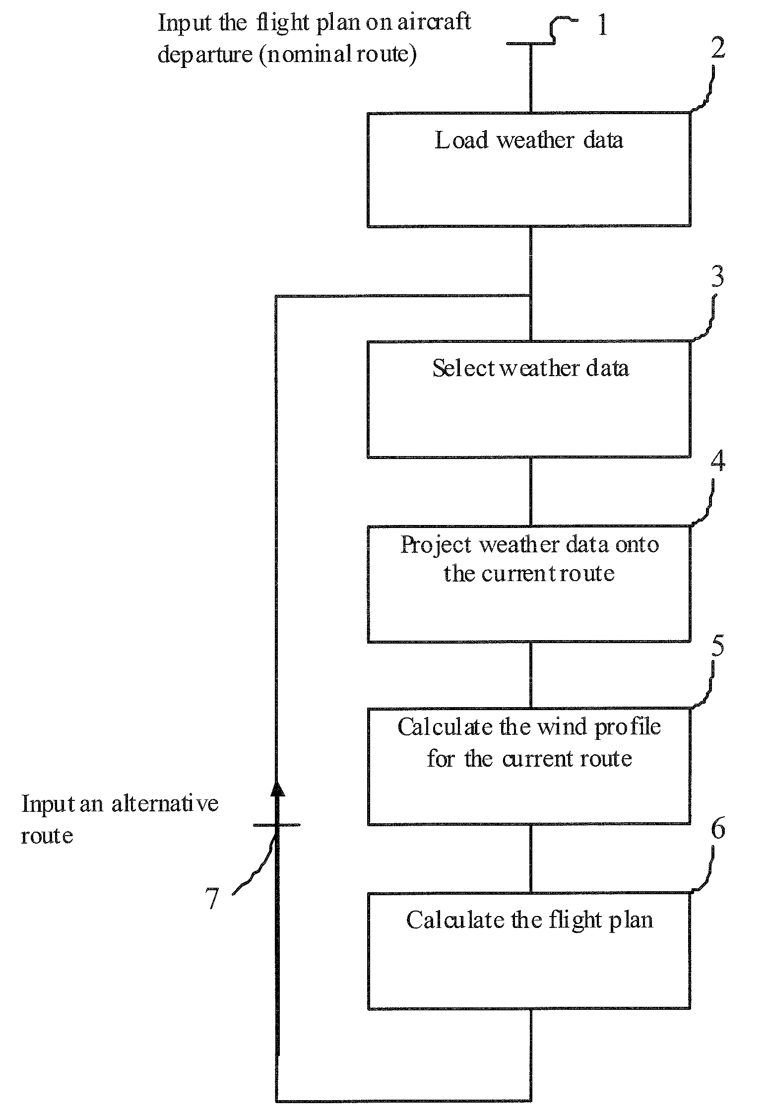
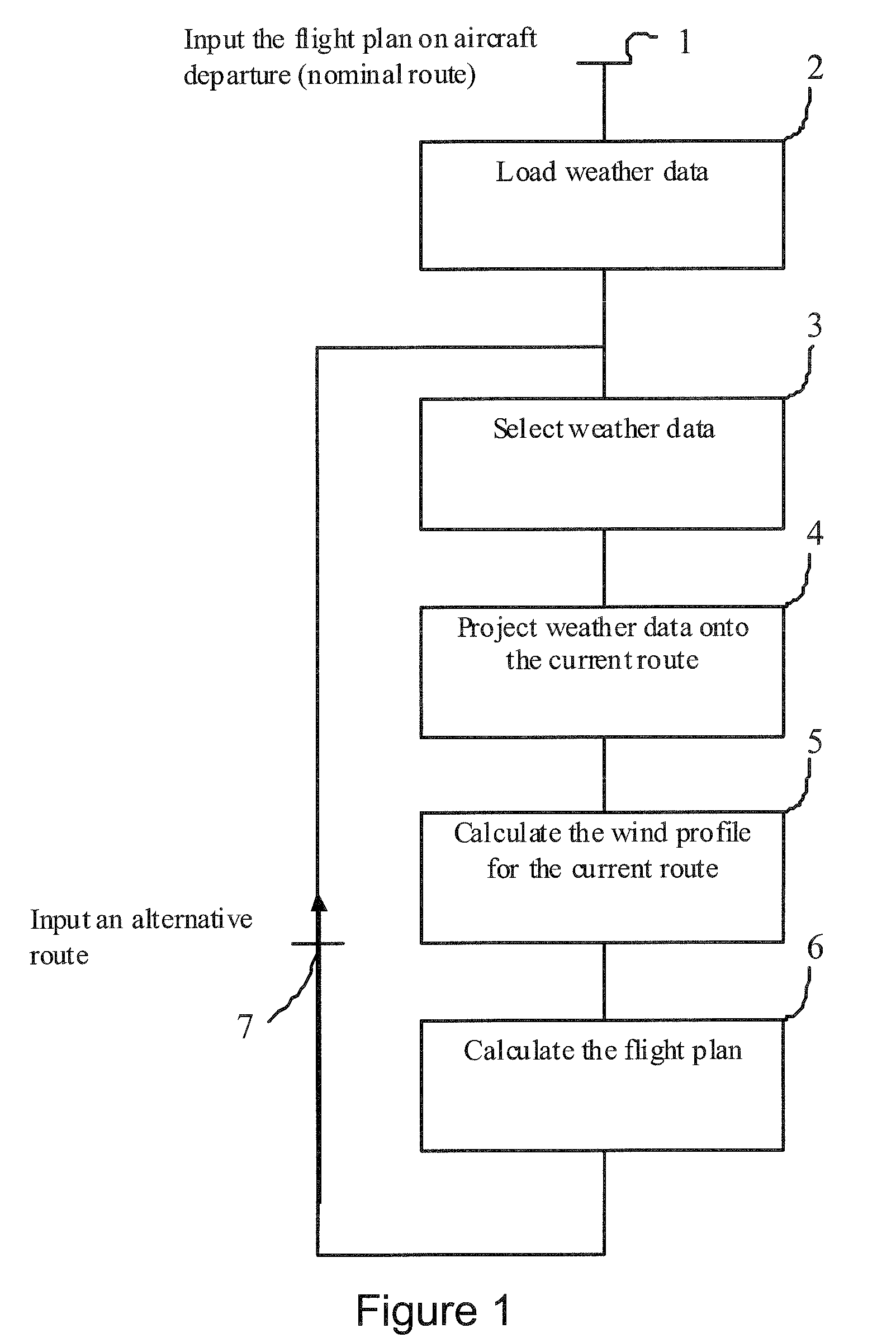
[0035]In a first phase symbolized by step 1 of FIG. 1, at the moment of departure the flight plan is input by the pilot on the basis of data contained in the navigation database. The pilot enters several aircraft parameters: the weight, the flight plan, the span of cruising levels and one or more of the optimization criteria. These input data allow the functions of the FMS to calculate respectively the lateral trajectory and the vertical profile which minimizes the cost.

[0036]In a second phase represented by step 2, the meteorological data are loaded aboard the aircraft. The pilot can thereafter enter and / or receive by datalink (ACARS for “Aircraft Communications Addressing and Reporting System”) the meteorological data. The communication management unit CMU receives the messages coming from the ground and / or satellites. These messages are thereafter decoded so as to be utilized by the FMS. These data relate to:[0037]the wind data on the climb phase relating to the strength and dire...


PUM


Abstract

The invention relates to a meteorological modelling method for calculating an aircraft flight plan, the aircraft comprising a communication means and a navigation management system.The method comprises at least the following steps: the communication means carries out the acquisition of meteorological prediction data related to waypoints in proximity to the nominal route in addition to the waypoints belonging to the nominal route, the navigation management system allocates by projection onto the current route of the aircraft the prediction data for the said waypoints not belonging to the current route, the navigation management system calculates the meteorological prediction data for the waypoints of the current route of the flight plan according to the prediction data allocated by projection onto the current route of the aircraft.The invention is a modelling method for aircraft navigation management systems.

Description

PRIORITY CLAIM[0001]This application claims priority to French Patent Application Number 08 06902, entitled Meteorological Modelling Method for Calculating an Aircraft Flight Plan, filed on Dec. 9, 2008.FIELD OF THE INVENTION[0002]The field of the invention relates to schemes for calculating an aircraft's flight plan prediction data. In particular, the invention is a meteorological modelling method for calculating the flight plan, notably for modelling the profile of the winds of the navigation management system onboard the aircraft.BACKGROUND OF THE INVENTION[0003]In recent years the increase in traffic and the resulting load on air traffic control has led to efforts to improve flight prediction systems so as to guarantee the safety but also the economic viability of air transport. Meteorological uncertainties are the main causes of time related vagaries when calculating flight plans. The navigation management systems of aircraft, more commonly called FMS for “Flight Management Sys...

Claims


Application Information

Patent Timeline
Patent Type & Authority Applications(United States)
IPC IPC(8): G01C23/00
CPCG01W1/08G01W1/10G05D1/0202G08G5/0039G08G5/0091
Inventor LACOMBE, ANTOINEBLANCHON, XAVIERCOULMEAU, FRANCOIS
Owner THALES SA
Why Eureka
Try Eureka