Submarine topography six-dimensional grid mapping method

a mapping method and topography technology, applied in the field of marine mapping, can solve the problems that the three-dimensional grid of the submarine topography cannot meet the current demands, and achieve the effects of accurate mapping data, wide application range, and convenient operation

Active Publication Date: 2015-07-09
SECOND INST OF OCEANOGRAPHY MNR
View PDF1 Cites 3 Cited by
  • Summary
  • Abstract
  • Description
  • Claims
  • Application Information

AI Technical Summary

Benefits of technology

The present invention is accurate in mapping data and easy to operate, making it useful in a wide range of applications. It is also less influenced by natural weather and other factors when mapping Chinese coasts and demarcating marine borders.

Problems solved by technology

However, with the requirement for broader application and further research, the submarine topography three-dimensional grid cannot satisfy the current demands.

Method used


Image

  • Submarine topography six-dimensional grid mapping method
  • Submarine topography six-dimensional grid mapping method
  • Submarine topography six-dimensional grid mapping method

Examples


embodiment 1

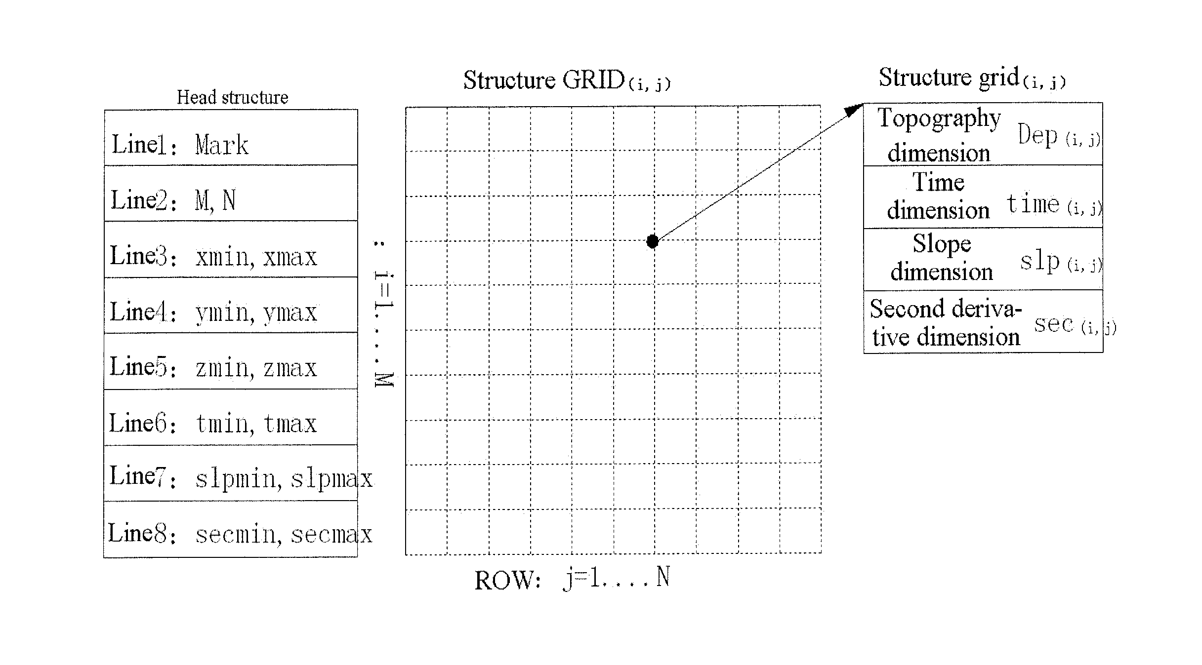
[0053]A submarine topography six-dimensional grid mapping method, comprises the detailed mapping process as follows.

[0054](1) Submarine Topography Six-Dimensional Grid Structure

[0055]Transmitting measured numerical values to a six-dimensional grid structure processing device through a submarine coordinate numerical value measuring instrument, wherein the processing device divides submarine coordinate measured data points into two parts, one part is a head structure “Head” for describing and storing integral information of the grid structure, and the other part is a data set

GRID(i,j)={grid(i,j)i=1,Mj=1,N}

for storing the grid.

[0056]The head structure “Head” consists of eight lines.

[0057]The first line refers to mark “Mark”.

[0058]The second line refers to M and N, representing the line quantity and row quantity of the grid.

[0059]The third line refers to xmin and xmax, representing the minimum and maximum values of the X-coordinate of the grid.

[0060]The fourth line refers to ymin and ym...


PUM


Abstract

The present invention discloses a submarine topography six-dimensional grid mapping method, and particularly to a method based on known discrete bathymetric data points. According to the present invention, a submarine topography six-dimensional grid mapping method including X-coordinate, Y-coordinate, water depth, slope, second derivative and measuring time is established, a submarine topography three-dimensional grid on the basis of discrete water depth data and measuring time is formed, and then submarine slope and second derivative of each grid point are calculated and the measuring time is superposed simultaneously, thus forming a submarine topography six-dimensional grid technical method. The present invention comprises a plurality of steps: establishing a submarine topography six-dimensional grid structure and a topography dimension grid, establishing a time dimension grid, establishing a slope dimension grid, and establishing a second derivative dimension grid. The present invention has the advantages of being accurate in mapping data, convenient to operate, wide in application range, little in influence of natural weather and the like in the process of Chinese coastal mapping and marine demarcation.

Description

TECHNICAL FIELD[0001]The present invention relates to a submarine topography six-dimensional grid mapping method including X-coordinate, Y-coordinate, water depth, slope, second derivative and measuring time, and particularly to a technical method, which particularly forms a submarine topography three-dimensional grid on the basis of discrete water depth data and measuring time, and then calculates submarine slope and second derivative of each grid point, and simultaneously superposes the measuring time, thus forming a submarine topography six-dimensional grid technical method and storing in a rational structure. The present invention relates to the technical fields of marine mapping, computer graphics, submarine science and the like.BACKGROUND ART[0002]A submarine topography three-dimensional grid has wide applications and a submarine topography grid is applied to any field related to the submarine topography, for example: mapping of foundation maps such as submarine topography map...

Claims


Application Information

Patent Timeline
IPC IPC(8): G01V9/00
CPCG01V9/00G01C13/00G01V20/00
InventorWU, ZIYINLI, JIABIAOLI, SHOUJUNSHANG, JIHONGLUO, XIAOWEN
OwnerSECOND INST OF OCEANOGRAPHY MNR