
Surveying system

a surveying system and surveying technology, applied in the field of surveying systems, can solve the problem of requiring a skilled surveyor to opera

Active Publication Date: 2015-09-17
BELL BENJAMIN
View PDF1 Cites 29 Cited by
  • Summary
  • Abstract
  • Description
  • Claims
  • Application Information

AI Technical Summary

Benefits of technology

The patent describes a surveying system that uses an unmanned aerial vehicle with a total station and mobile communication stations to precisely triangulate and control the vehicle's location. Additionally, the system allows construction drawings to be loaded and the vehicle to locate itself at specific points for marking construction grid lines. The system also includes a charging station for recharging the vehicle's batteries and monitoring their charge level to prevent damage or retrieval issues.

Problems solved by technology

This method, however, can be cumbersome in that it requires a team of skilled surveyors to man the total station and the targets to physically mark the control lines.
However, even with this improvement a team of surveyors is still needed to man the total station and to physically move the target around the construction site.
However, this still requires a skilled surveyor to operate the total station and move the target from point to point.

Method used


Image

  • Surveying system
  • Surveying system
  • Surveying system

Examples


Embodiment Construction

[0023]The detailed description set forth below is intended as a description of the presently preferred embodiment of the invention, and is not intended to represent the only form in which the present invention may be constructed or utilized. The description sets forth the functions and sequences of steps for constructing and operating the invention. It is to be understood, however, that the same or equivalent functions and sequences may be accomplished by different embodiments and that they are also intended to be encompassed within the scope of the invention.

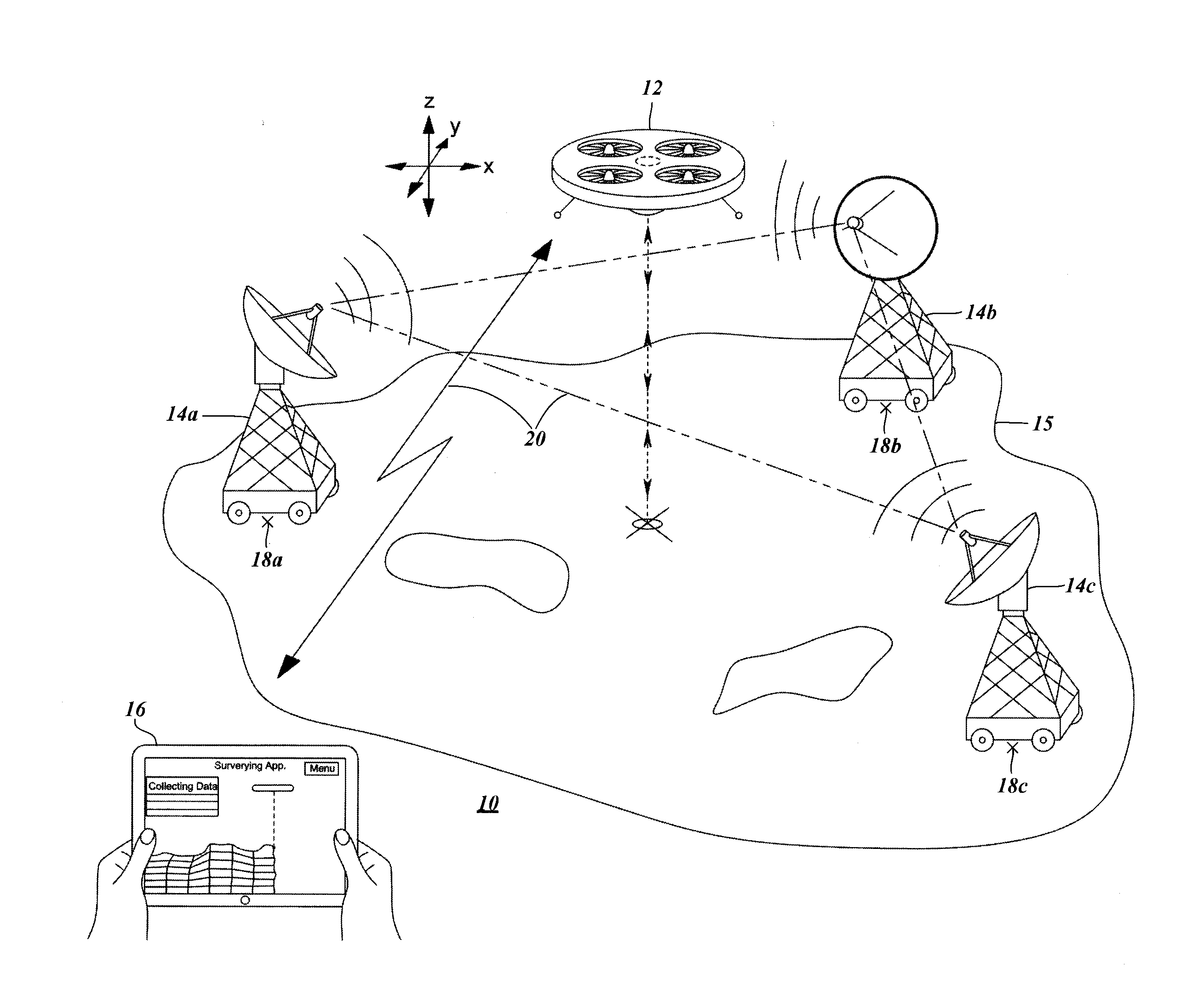
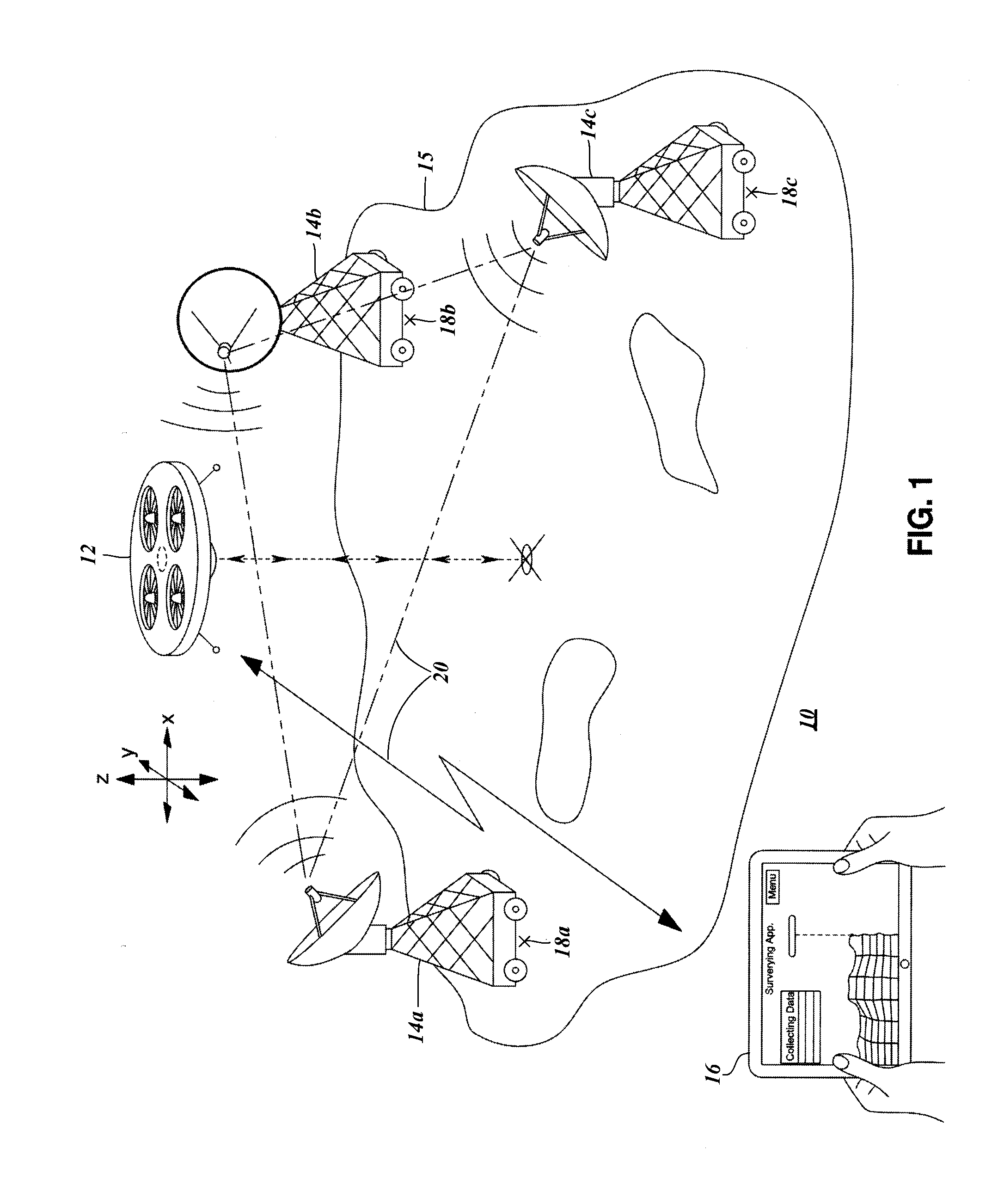
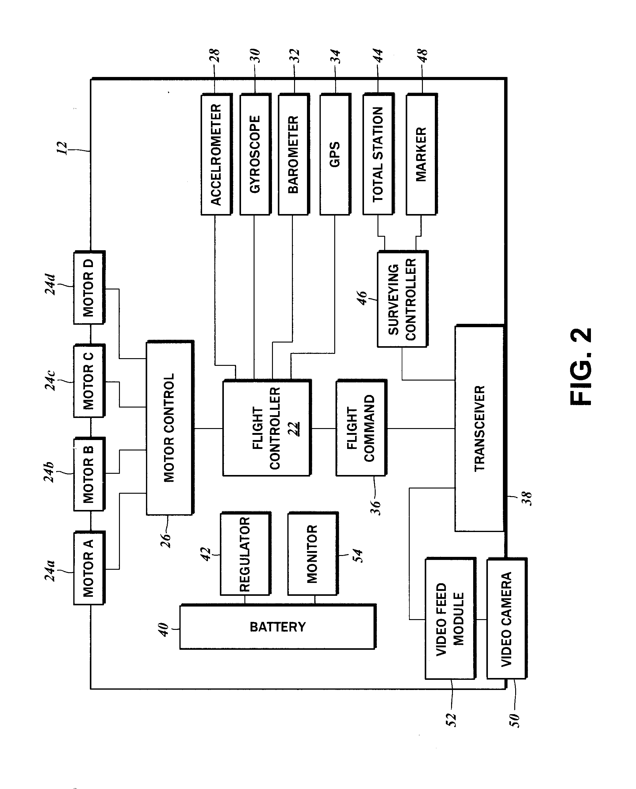
[0024]As shown in FIG. 1, a surveying system 10 of the present disclosure includes a vehicle unit 12, a plurality of mobile communication stations 14, and a controller unit 16. In order to utilize the surveying system 10, a plurality of the mobile communication stations 14 are located on a survey site 15 at specific coordinates 18. More particularly, there is a first mobile communication station 14a positioned at a first locati...


PUM


Abstract

A surveying system having a total station integrated into an unmanned aerial vehicle communicates with a plurality of mobile communication stations that are located on known site coordinates. By locating the mobile communication stations on known coordinates, the location of the aerial vehicle is precisely triangulated and controlled. Construction drawings are loaded into the system, thereby allowing the vehicle to locate itself at specific points designated in the drawings for the marking of on-site construction grid lines.

Description

CROSS-REFERENCE TO RELATED APPLICATIONS[0001]This application relates to and claims the benefit of U.S. Provisional Application No. 61 / 954,148 filed Mar. 19, 2014 and entitled “SURVEYING SYSTEM,” the disclosure of which is wholly incorporated by reference in its entirety herein.STATEMENT RE: FEDERALLY SPONSORED RESEARCH / DEVELOPMENT[0002]Not ApplicableBACKGROUND[0003]1. Technical Field[0004]The present invention relates to a surveying system. In particular, the invention relates to a surveying system having an unmanned aerial vehicle capable of establishing construction gridlines at the construction site from the construction drawings.[0005]2. Related Art[0006]Surveying is the technique of accurately determining the three-dimensional position of points and the distances and angles between them, utilizing in part geometry and trigonometry. In surveying, various kinds of surveying instruments, such as theodolites or total stations, are commonly used for measuring distances and / or angle...

Claims


Application Information

Patent Timeline
IPC IPC(8): G05D1/00B05D1/02B05B13/00G05D1/02G01C15/04
CPCG05D1/0022G05D1/0202G05D1/0016G05D1/0038G05D1/0094B05D1/02G05D1/0246G05D1/028G01C15/04B05B13/005G05D1/0225G05D1/102B64U80/25B64U2101/31B64U10/14B64U10/10B64U2101/30B64U2201/20B64C39/024G01S19/14G05D1/0278
Inventor GIL, JESSE
Owner BELL BENJAMIN
Learn More