Satellite geodesy and reservoir performance

a satellite geodesy and reservoir technology, applied in the field of remote sensing of subterranean formations, can solve the problems of limited number of non-subsurface analytical methods, sensitive and expensive equipment for collecting computationally intensive data, and inability to accurately detect the depth of the reservoir

Inactive Publication Date: 2016-08-18
CONOCOPHILLIPS CO
View PDF0 Cites 8 Cited by
  • Summary
  • Abstract
  • Description
  • Claims
  • Application Information

AI Technical Summary

Problems solved by technology

These subsurface methods often require delicate and expensive equipment collecting computationally intensive data.
Currently, there are limited number of non-subsurface analytical methods that can independently, conveniently, and cost-effectively assess reservoirs for exploration, production, and / or containment evaluation purposes.
Radar interferometry has seen some use in oil and gas applications such as production monitoring in heavy oil fields (Stancliffe and van der Wooij, 2001; Gu et al., 2011; Teatini et al., 2011; Khakim et al., 2012) but has not yet been fully realized for subsurface faults within oil and gas fields.

Method used


Image

  • Satellite geodesy and reservoir performance
  • Satellite geodesy and reservoir performance
  • Satellite geodesy and reservoir performance

Examples


example

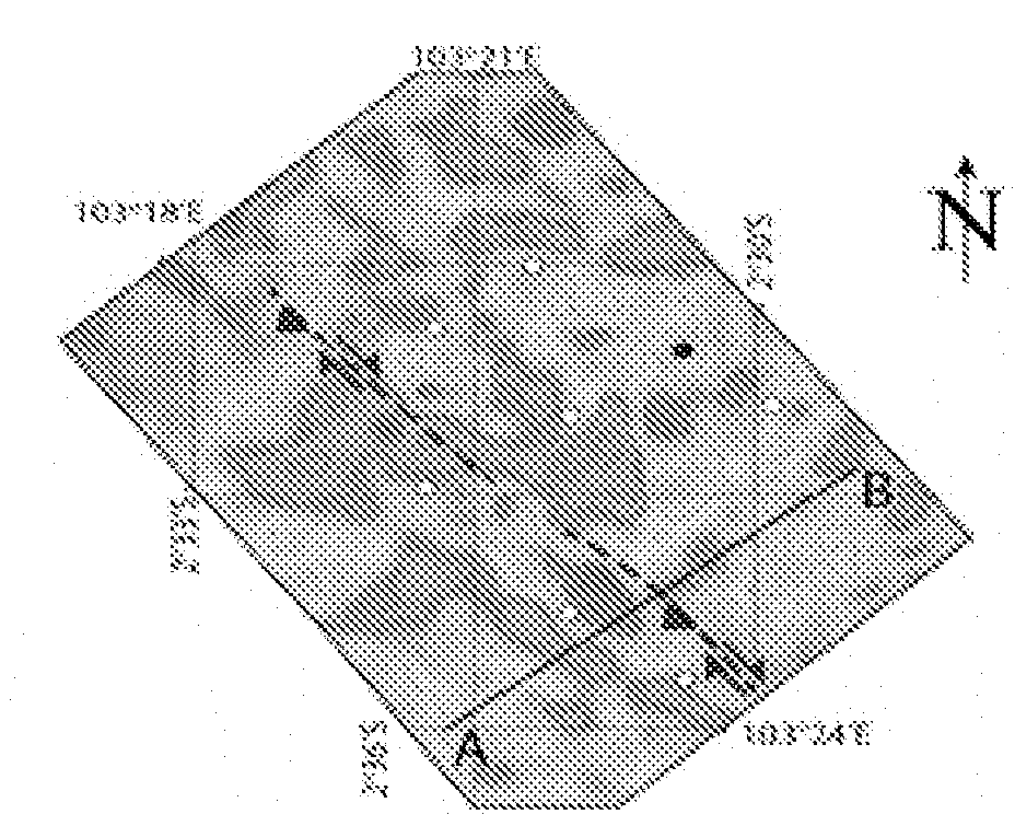
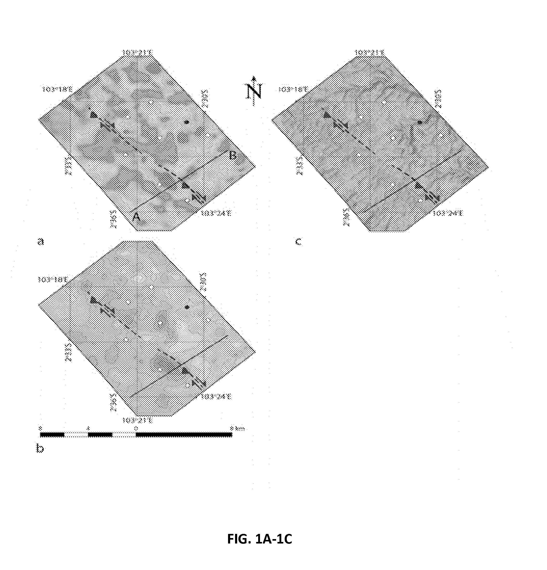
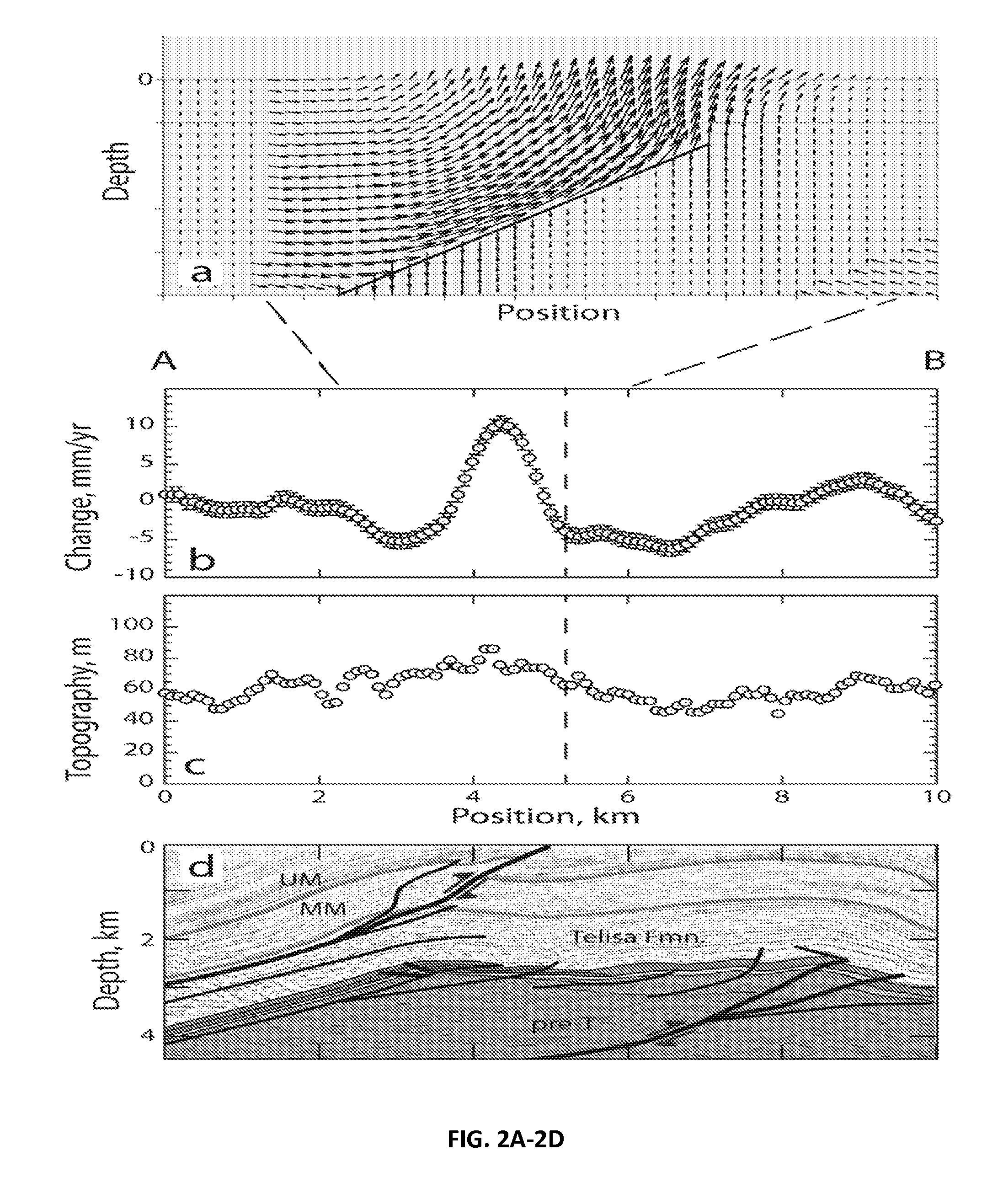
[0022]This Example describes an embodiment of the present invention as applied to an oil and gas producing field, Suban field located in Sumatra, Indonesia (e.g., Schultz et al., 2014a, b). Synthetic aperture radar data were obtained from the Advanced Land Observing Satellite (ALOS) via an L-band (23.6 cm wavelength) radar which provides good temporal coherence for constructing interferograms. Twenty-six obtained raw images (19 ascending and 7 descending acquisitions) were used to perform an interferometry analysis (e.g., Soofi and Sandwell, 2010; Tong et al., 2013).

[0023]During the interferometry analysis, raw binary radar images were pre-processed and focused to form full-resolution SAR images. All SAR images were aligned to a single image with 2D cross-correlation techniques. Typically, the image alignment needs to be accurate within ˜1 pixel (˜10 m) in order to construct the interferograms. During this process, phase due topography was removed and the residual phase was unwrappe...


PUM


Abstract

Satellite geodesy can identify fault-related surface deformation above onshore oil and gas fields through the use of radar interferometry (InSAR). The method provides an independent and cost-effective approach to identifying faults and damage zones that can be associated with increased reservoir performance beyond traditional tools of subsurface imaging and reservoir evaluation.

Description

PRIORITY CLAIM[0001]This application is a non-provisional application which claims benefit under 35 USC §119(e) to U.S. Provisional Application Ser. No. 62 / 081,945 filed Nov. 19, 2014, entitled “SATELLITE GEODESY AND RESERVOIR PERFORMANCE,” which is incorporated herein in its entirety.FIELD OF THE INVENTION[0002]The present invention relates generally to remote sensing of subterranean formations. More particularly, but not by way of limitation, embodiments of the present invention include tools and methods for assessing oil and gas reservoirs using radar interferometry.BACKGROUND OF THE INVENTION[0003]Traditionally, oil and gas reservoirs have been characterized by using subsurface engineering methods. Improving oil and gas reservoir performance has relied on data obtained by subsurface methods that feature, for example, wellbore geomechanics, sonic logs, and seismic interpretation of subsurface reflectors. These subsurface methods often require delicate and expensive equipment coll...

Claims


Application Information

Patent Timeline
Patent Type & Authority Applications(United States)
IPC IPC(8): G01S13/90E21B49/00
CPCE21B47/00G01S13/9023E21B49/00G01S13/885
Inventor SCHULTZ, RICHARD A.SOOFI, KHALID A.HENNINGS, PETER H.
Owner CONOCOPHILLIPS CO
Why Eureka
Try Eureka