System and method for fusion of camera and global navigation satellite system (GNSS) carrier-phase measurements for globally-referenced mobile device pose determination

a global navigation satellite and carrier phase technology, applied in the field of navigation systems, can solve the problems of costly device accuracy and centimeter position accuracy, and achieve the effect of fast resolution, robustness, and accuracy

Inactive Publication Date: 2016-11-10
BOARD OF RGT THE UNIV OF TEXAS SYST
View PDF0 Cites 31 Cited by
  • Summary
  • Abstract
  • Description
  • Claims
  • Application Information

AI Technical Summary

Benefits of technology

[0036]Prior to this invention, obtaining centimeter position and sub-degree orientation accuracy for devices has been costly, particularly for consumer applications. Earlier techniques required either GPS-aided inertial navigation systems (INS) or motion-capture systems costing thousands of dollars. This invention provides a system and method for fusion of camera (e.g., mobile phone camera) and global navigation satellite system (GNSS) carrier-phase measur

Problems solved by technology

Prior to this invention, obtaining centimeter position and sub-degree orientati

Method used


Image

  • System and method for fusion of camera and global navigation satellite system (GNSS) carrier-phase measurements for globally-referenced mobile device pose determination
  • System and method for fusion of camera and global navigation satellite system (GNSS) carrier-phase measurements for globally-referenced mobile device pose determination
  • System and method for fusion of camera and global navigation satellite system (GNSS) carrier-phase measurements for globally-referenced mobile device pose determination

Examples


Embodiment Construction

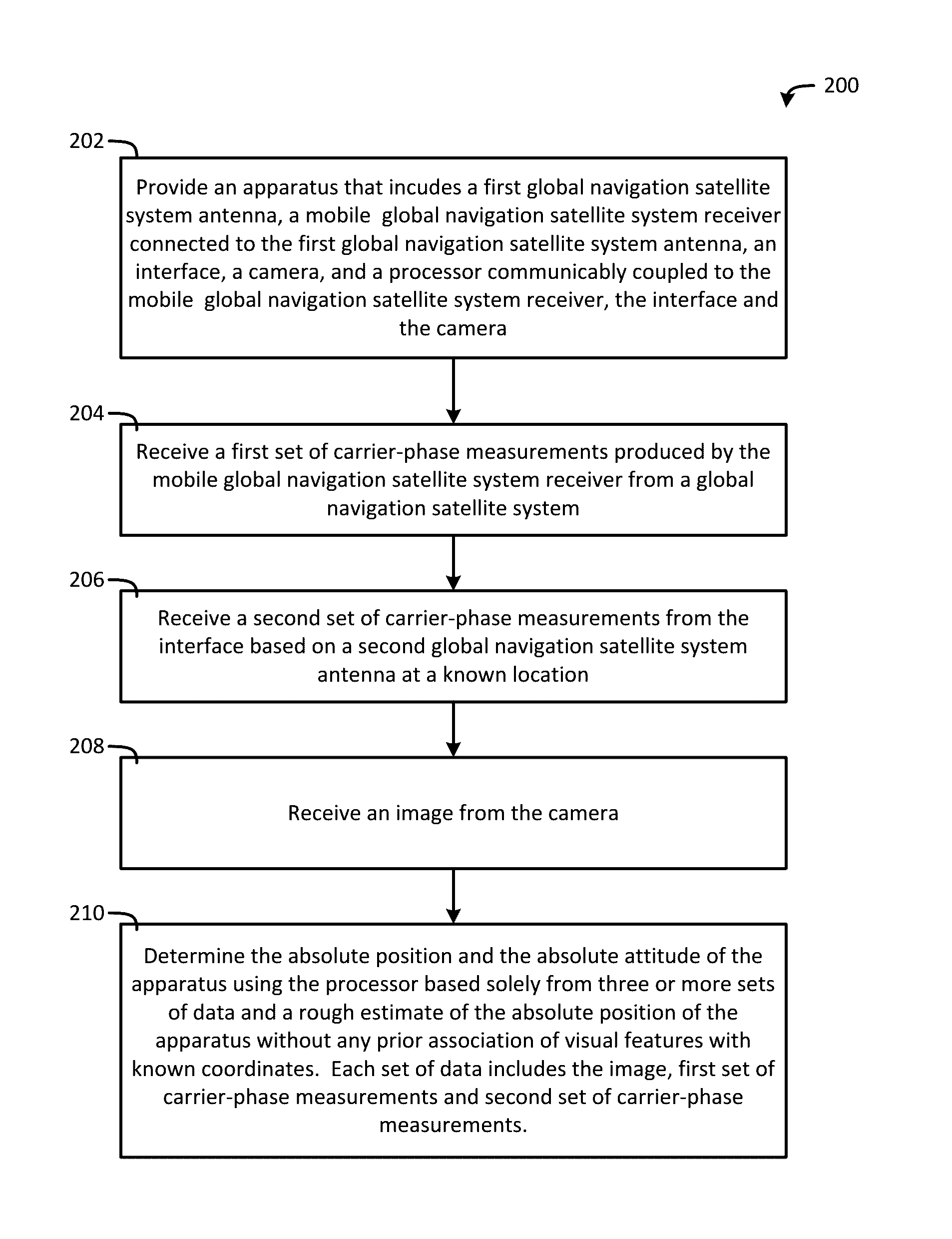
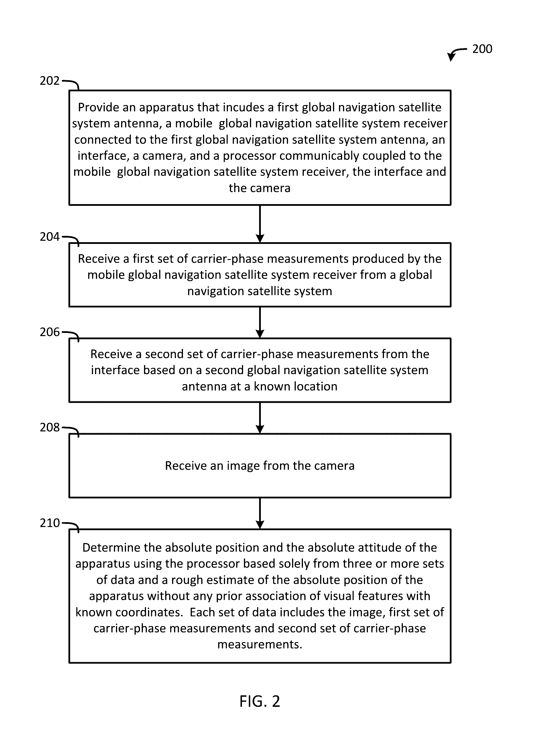
[0079]While the making and using of various embodiments of the present invention are discussed in detail below, it should be appreciated that the present invention provides many applicable inventive concepts that can be embodied in a wide variety of specific contexts. The specific embodiments discussed herein are merely illustrative of specific ways to make and use the invention and do not delimit the scope of the invention.

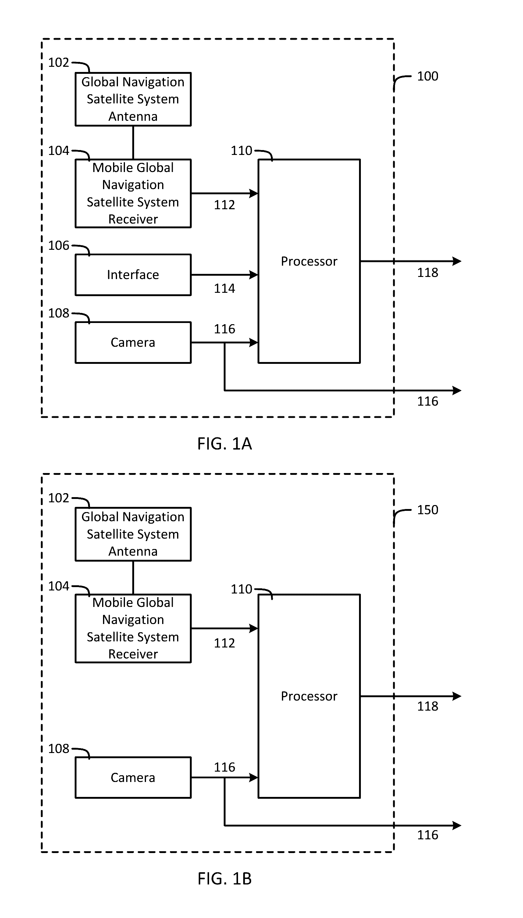
[0080]A system and method for using carrier-phase-based satellite navigation and visual navigation to recover absolute and accurate position and orientation (together known as “pose”) without an a priori map of visual features is presented. “Absolute” means that an object's pose is determined relative to a global coordinate frame. Satellite navigation means that one or more Global Navigation Satellite Systems (GNSS) are employed. A priori map of visual features means that the system has no prior knowledge of its visual environment; i.e., it has no prior associati...


PUM


Abstract

An apparatus including a global navigation satellite system (GNSS) antenna, a mobile GNSS receiver connected to the GNSS antenna, a camera operable to produce an image, and a processor communicably coupled to the mobile GNSS receiver and the camera. The mobile GNSS receiver is operable to produce a set of carrier-phase measurements from a GNSS. The processor is operable to receive the image and the set of carrier-phase measurements, extract point feature measurements from the image, model the point feature measurements based on the image to produce a point feature model, model the set of carrier-phase measurements to produce a carrier-phase model, execute a cost function including the point feature measurements, the carrier-phase measurements, the point feature model, and the carrier-phase model, and determine a state associated with the apparatus based on the executed cost function.

Description

CROSS-REFERENCE TO RELATED APPLICATIONS[0001]This application is a continuation-in-part of U.S. patent application Ser. No. 14 / 608,381, filed Jan. 29, 2015, which claims the benefit of U.S. Provisional Patent Application No. 61 / 935,128, filed Feb. 3, 2014, the entire contents of both of which are hereby incorporated by reference.FIELD OF THE INVENTION[0002]The present invention relates generally to the field of navigation systems and, more particularly, to a system and method for using global navigation satellite system (GNSS) navigation and visual navigation to recover an absolute position and attitude of an apparatus without any prior association of visual features with known coordinates.BACKGROUND OF THE INVENTION[0003]Augmented reality (AR) is a concept closely related to virtual reality (VR), but has a fundamentally different goal. Instead of replacing the real world with a virtual one like VR does, AR seeks to produce a blended version of the real world and context-relevant vi...

Claims


Application Information

Patent Timeline
IPC IPC(8): G01S19/48G01S19/26G01S19/55G01S19/44
CPCG01S19/48G01S19/55G01S19/26G01S19/44G01S19/43G01S19/49G01S19/54G01S5/16G01S19/485
Inventor HUMPHREYS, TODDPESYNA, JR., KENNETHSHEPARD, DANIEL
Owner BOARD OF RGT THE UNIV OF TEXAS SYST
Why Eureka
Try Eureka