Non-Rigid Registration for Large-Scale Space-Time 3D Point Cloud Alignment

a space-time, non-rigid technology, applied in image enhancement, instruments, image data processing, etc., can solve the problems of non-linear distortion, large errors in misalignment and inaccurate registration, and registration errors when aligning scans

Active Publication Date: 2017-02-16
NOKIA TECHNOLOGLES OY
View PDF2 Cites 91 Cited by
  • Summary
  • Abstract
  • Description
  • Claims
  • Application Information

AI Technical Summary

Benefits of technology

[0005]In one embodiment, an apparatus is provided comprising at least one processor and at least one memory including computer program code for one or more programs. The at least one memory and the computer program code configured to, with the at least one processor, cause the apparatus to receive an anchor point cloud data set and at least one corresponding point cloud data set, wherein at least a portion of the anchor point cloud data set and at least a portion of the corresponding point cloud data set represent the same physical surface, extract a plurality of surface feature points from the anchor point cloud data set and from the at least one corresponding point cloud data set, and determine coordinates for each point of the anchor point cloud data set and the at least one corresponding point cloud data set. The computer program code and processor may further cause the apparatus to match surface feature points of the plurality of surface feature points between the anchor point cloud data set and the at least one corresponding point cloud data set, align the at least one corresponding point cloud data set to the anchor point cloud data set based on the matched surface feature points between the anchor point cloud data set and the at least one corresponding point cloud data set, and divide the aligned at least one corresponding point cloud data set and the anchor point cloud data set into a plurality of point cloud data set portions, wherein each point cloud data set portion overlaps with at least one other point cloud data set portion. The computer program code and process may further cause the apparatus to, for each point cloud data set portion, move matched surface feature points of the corresponding point cloud data set toward the determined coordinates of the matched surface feature points of the anchor point cloud data set, and for each point cloud data set portion, move the remaining points of the at least one corresponding point cloud data set based on the moved matched surface feature points and the determined coordinates for each remaining point.

Problems solved by technology

Despite the use of multi-band global positioning systems (GPS) and high-precision inertial measurement unit (IMU) with these systems, registration errors occur when aligning scans.
Errors in misalignment and inaccurate registration can be as big as a few meters, even with the most accurate and expensive scanning equipment.
Non-linear distortions, which are typically caused by the scanner's internal drift, cannot be resolved by rigid transformation.
ICP methods estimate a rigid transformation between two point clouds but fail to resolve non-rigid deformation and are thus inaccurate in aligning large-scale urban environment scans.
ICP methods and ICP variants are further ineffective when ground truth or reference data for the point clouds are unavailable.
Artifacts may appear in the scans as non-rigid distortions due to the system drift or due to calibration error.
Due to errors in the scans, surface feature points may not be fully aligned following the rigid transform.
Solving a large matrix may be problematic due to the limitations of memory and processing speed of various computers.
Additionally, the illustrations are merely representational and may not be drawn to scale.

Method used


Image

  • Non-Rigid Registration for Large-Scale Space-Time 3D Point Cloud Alignment
  • Non-Rigid Registration for Large-Scale Space-Time 3D Point Cloud Alignment
  • Non-Rigid Registration for Large-Scale Space-Time 3D Point Cloud Alignment

Examples


Embodiment Construction

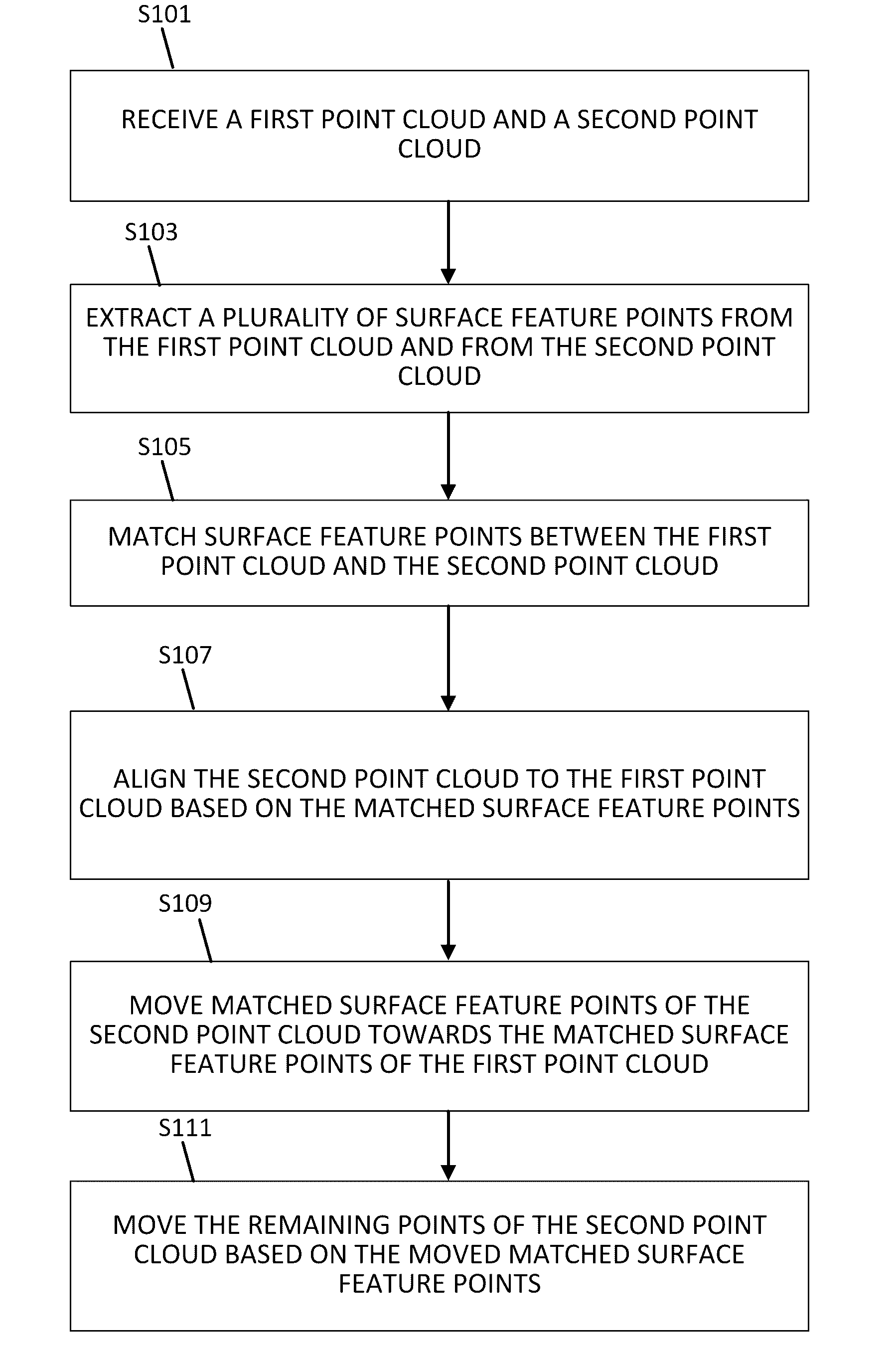
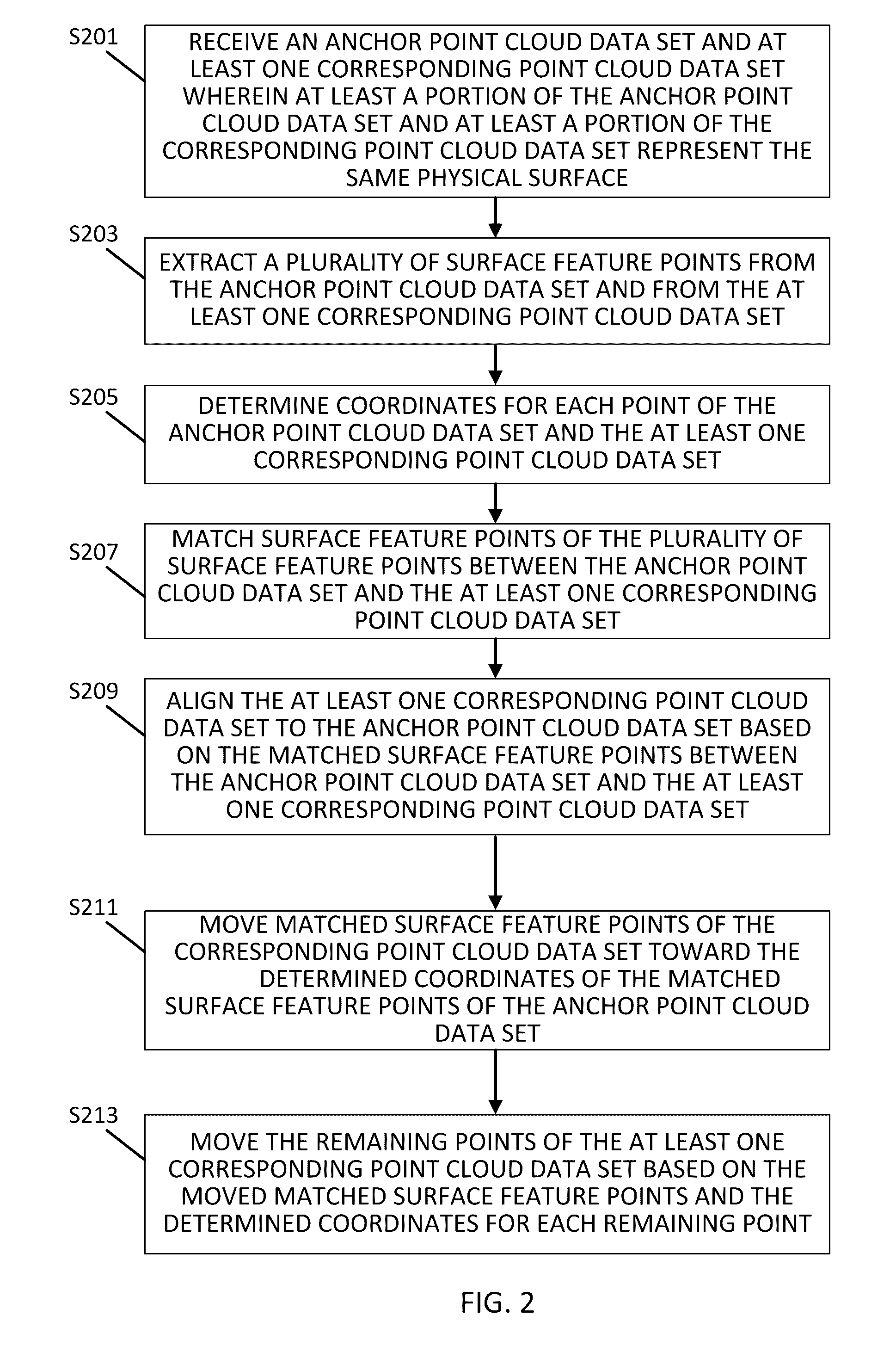
[0015]Multiple three-dimensional scans of the same geographic area or physical object are used in map navigation and urban planning. These scans may be collected at different times: within minutes, days, or years between the scan. Scans that are collected with the aid of a vehicle may have offsets of several meters due to variations in driving. Artifacts may appear in the scans as non-rigid distortions due to the system drift or due to calibration error.

[0016]The subject technology for non-rigid alignment addresses the alignment of multiple point cloud data scans into a common coordinate plane for point cloud data sets of the same geographic area and effectively resolves non-rigid distortion. One goal of the subject technology for non-rigid alignment is to improve data registration accuracy in the presence of non-rigid distortion. A further goal is to conduct non-rigid transformations on large data sets without exceeding the computational capabilities of a system. Yet another goal o...


PUM


Abstract

Point cloud data sets representing overlapping physical areas are received. Surface feature points are extracted from the point cloud data sets and coordinates are determined for each point of the point cloud data sets. The point cloud data sets are aligned based on matching surface feature points between the point cloud data sets. Matched surface feature points are moved toward the coordinates of corresponding matched surface feature points and the remaining points are moved based on the moved matched surface feature points and the determined coordinates for each point.

Description

FIELD[0001]The following disclosure relates to alignment of multiple three-dimensional point cloud scans, and more particularly, to the reduction of distortion within large-scale scans using non-rigid transformations.BACKGROUND[0002]Computer based navigation systems such as autonomous driving vehicles and mapping applications have created a need to acquire large area scans, photographs, and point cloud data sets (point cloud data sets include data sets obtained by remote sensing using infrared lasers, often called Light Detection And Ranging, or LiDAR). Large scale LiDAR scans (such as a scan of several city blocks) may be captured from either ground or aerial based mobile platforms. Despite the use of multi-band global positioning systems (GPS) and high-precision inertial measurement unit (IMU) with these systems, registration errors occur when aligning scans. Errors in misalignment and inaccurate registration can be as big as a few meters, even with the most accurate and expensive...

Claims


Application Information

Patent Timeline
Patent Type & Authority Applications(United States)
IPC IPC(8): G06T7/00G01C21/36G06T3/00G06K9/46G06K9/62G06V10/44G06V10/75
CPCG06T7/0028G06K9/4604G06K9/6201G06T2207/30248G06T7/0081G01C21/36G06T2207/10028G06T3/0068G06T7/33G06V20/64G06V20/56G06V10/44G06V10/75G06F18/22G06T7/30
Inventor CHEN, XINYANG, RUIGANG
Owner NOKIA TECHNOLOGLES OY
Why Eureka
Try Eureka