
Automatic calibration of geolocation analytic systems and operator network equipment parameters

a geolocation and network equipment technology, applied in the field of automatic calibration of geolocation analytic systems and operator network equipment parameters, can solve the problems of difficult to achieve 18 inter cell spacing, low cost, and rare results

Active Publication Date: 2019-03-14
NETSCOUT SYSTEMS
View PDF3 Cites 5 Cited by
  • Summary
  • Abstract
  • Description
  • Claims
  • Application Information

AI Technical Summary

Benefits of technology

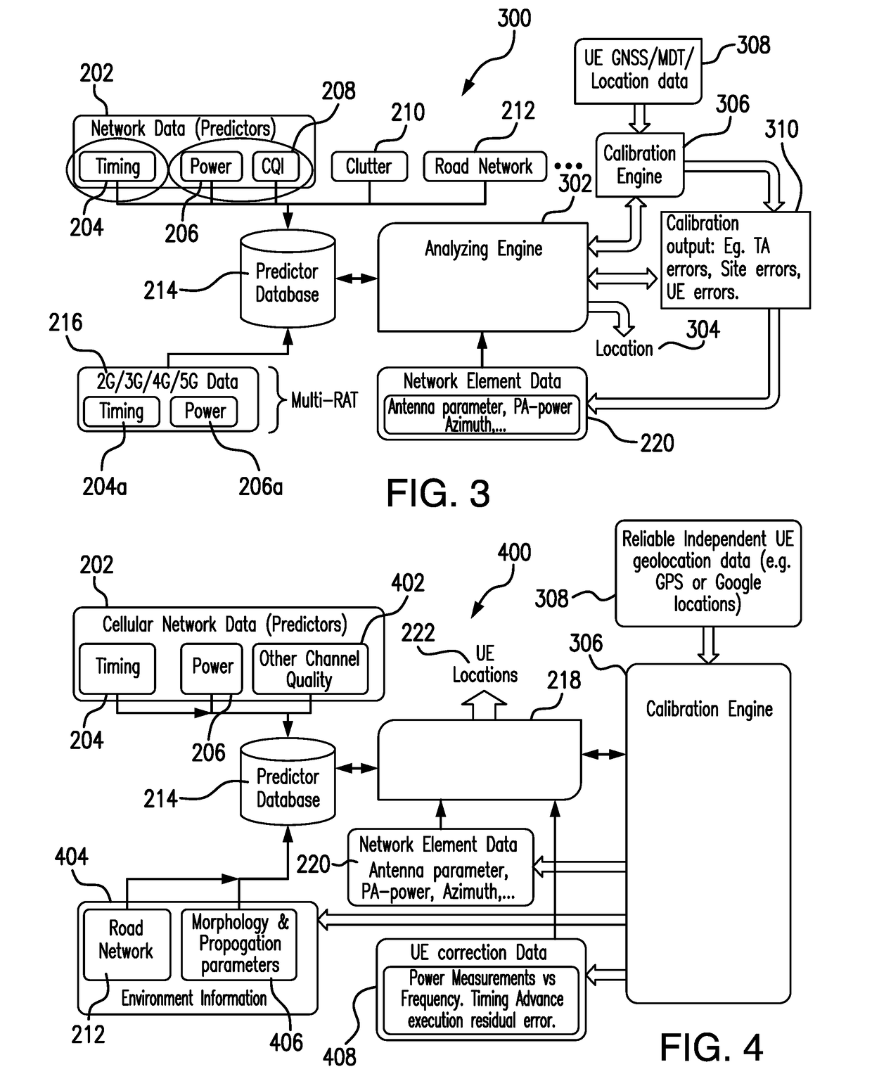
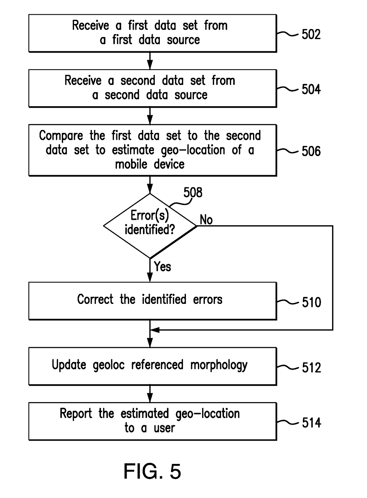
The patent describes a method and system for calibrating a geolocation analytic system in a wireless network. The system receives measurement data from a mobile device connected to the network and compares it to external geo-location data to estimate the device's location and identify any errors. The errors are then corrected based on the comparison. The technical effect of this patent is to provide a more accurate and reliable means of locating mobile devices in wireless networks.

Problems solved by technology

The accuracy of the geolocated data depends upon many factors and results better than ⅛ inter cell spacing is difficult to achieve.
However, drive testing is not advantageous in terms of cost and is seldom performed.

Method used


Image

  • Automatic calibration of geolocation analytic systems and operator network equipment parameters
  • Automatic calibration of geolocation analytic systems and operator network equipment parameters
  • Automatic calibration of geolocation analytic systems and operator network equipment parameters

Examples


Embodiment Construction

[0015]The present invention is now described more fully with reference to the accompanying drawings, in which illustrated embodiments of the present invention are shown wherein like reference numerals identify like elements. The present invention is not limited in any way to the illustrated embodiments as the illustrated embodiments described below are merely exemplary of the invention, which can be embodied in various forms, as appreciated by one skilled in the art. Therefore, it is to be understood that any structural and functional details disclosed herein are not to be interpreted as limiting, but merely as a basis for the claims and as a representative for teaching one skilled in the art to variously employ the present invention. Furthermore, the terms and phrases used herein are not intended to be limiting but rather to provide an understandable description of the invention.

[0016]Unless defined otherwise, all technical and scientific terms used herein have the same meaning as ...


PUM


Abstract

A method for calibrating geolocation analytic system in a wireless network includes receiving a first data set including measurement data associated with a mobile device connected to the wireless network from a first data source. A second data set comprising external geo-location data associated with the mobile device is received from a second data source. The first data set is compared to the second data set to estimate geo-location of the mobile device and to identify one or more errors using calibration function. The identified one or more errors are corrected based on the comparison.

Description

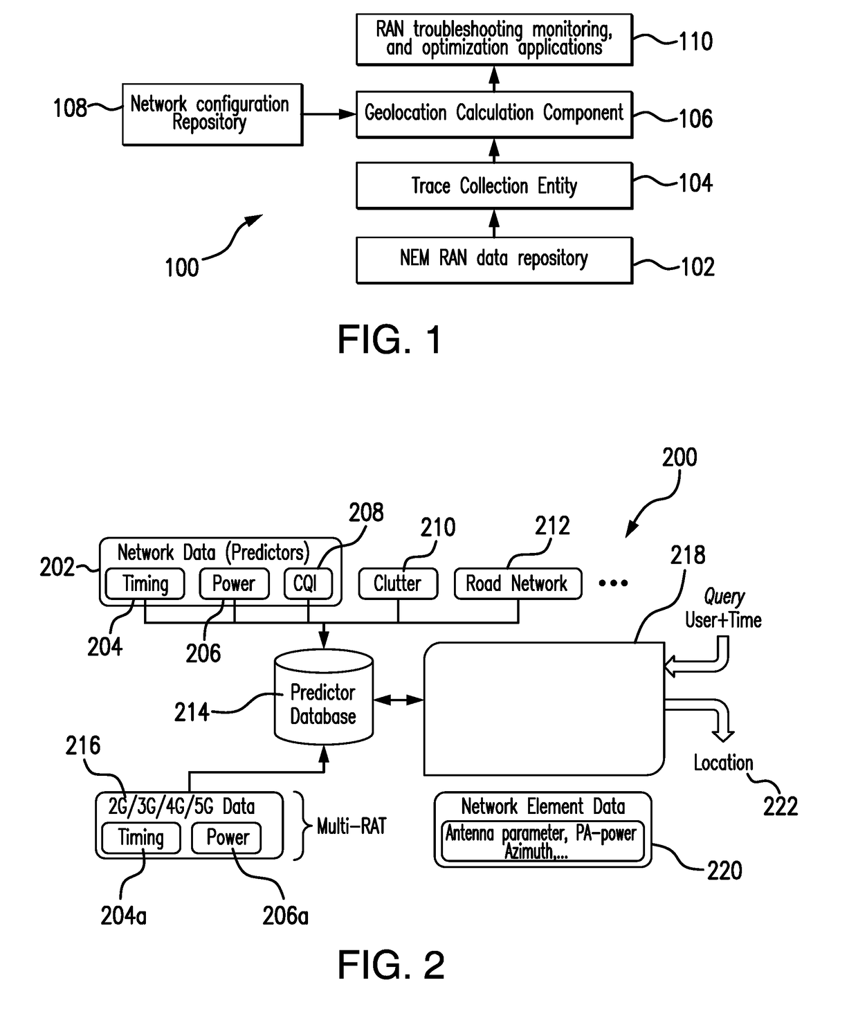
FIELD OF THE INVENTION[0001]Embodiments of the present invention relate generally to telecommunications and specifically to automatic calibration geolocation analytic systems and operator network equipment parameters.BACKGROUND OF THE INVENTION[0002]The increased terminal mobility offered by cellular telephone networks as well as mobile and WiFi radio data networks has brought about an increased demand for location-based services and applications. Location based services include, for example, fleet management, vehicle tracking, tracking for theft recovery, telemetry, emergency services, location identification, navigation, location based information services and location based advertising. A wide variety of technologies for locating mobile devices have been developed.[0003]Geoanalytic Radio Access Network (RAN) monitoring and optimization systems utilize NEM (Network Equipment Manufacturer) RAN signaling to troubleshoot mobile subscribers' issues and to provide RAN performance KPIs....

Claims


Application Information

Patent Timeline
Patent Type & Authority Applications(United States)
IPC IPC(8): H04W4/02G01S5/02
CPCH04W4/02G01S5/021G01S19/23G01S5/02521H04W24/02H04B17/27H04B17/373
Inventor FROEHLICH, ROBERT WILLIAMGAENGER, KARSTENLO, WING F.
Owner NETSCOUT SYSTEMS
Learn More