Efficient and scalable three-dimensional point cloud segmentation for navigation in autonomous vehicles

a technology of autonomous vehicles and point clouds, applied in the field of three-dimensional (3d) point cloud segmentation, can solve the problems of large runtime, unsuitable for fast, embedded, multiple input scenarios, and use of such solutions in high-resolution, high-speed, or real-time applications

Active Publication Date: 2019-10-10
APEX AI INC
View PDF0 Cites 34 Cited by
  • Summary
  • Abstract
  • Description
  • Claims
  • Application Information

AI Technical Summary

Benefits of technology

[0015]Accordingly, systems, methods, and non-transitory computer-readable media are disclosed for scalable 3D-point-cloud segmentation. In an embodiment, the described solution segments 3D point clouds, in real time, while being static-memory (i.e., only requiring a fixed, maximum amount of memory, so as to be suitable for embedded and safety-critical applications), able to handle multiple inputs simultaneously, and / or able to handle data over a wide range of distances with respect to the sensor.
[0016]In an embodiment, a method is disclosed. The method comprises using at least one hardware processor to: receive data from one or more sensors; generate a three-dimensional point cloud from the data received from the one or more sensors; segment the three-dimensional point cloud using a clustering algorithm by adding points from the three-dimensional point cloud to a spatial hash, for each unseen point in the three-dimensional point cloud, generating a new cluster, adding the unseen point to the cluster, marking the unseen point as seen, and, for each point that is added to the cluster, setting the point as a reference point, computing a reference threshold metric for the reference point, identifying all unseen neighbor points to the reference point in the spatial hash, based on the reference threshold metric, and, for each identified unseen neighbor point to the reference point, marking the unseen neighbor point as seen, computing a neighbor threshold metric for the neighbor point, determining whether or not the neighbor point should be added to the cluster based on the neighbor threshold metric, and, when the neighbor point is determined to be added to the cluster, adding the neighbor point to the cluster, and, when a size of the cluster reaches a threshold, adding the cluster to a cluster list, and outputting the cluster list; identify one or more objects based on the cluster list; and control one or more autonomous systems based on the identified one or more objects. The method may further comprise using the at least one hardware processor to, prior to segmenting the three-dimensional point, remove points outside a predefined range from the three-dimensional point cloud. Each point may comprise an x, y, and z coordinate, wherein the x and y coordinates represent a horizontal plane, wherein the z coordinate represents a vertical axis, and wherein removing points outside a predefined range comprises removing all points that have a z coordinate that has a value outside a predefined range of values. The method may further comprise using the at least one hardware processor to, prior to segmenting the three-dimensional point, remove ground points from the three-dimensional point cloud. Adding points from the three-dimensional point cloud to the spatial hash may comprise, for each point in the three-dimensional point cloud: quantizing coordinates of the point; computing a bin identifier for the point; generating a node that represents the point; determining whether or not a list of nodes is associated with the computed bin identifier in an associative mapping; when a list of nodes is determined to be associated with the computed bin identifier in the associative mapping, adding the generated node to the list of nodes associated with the computed bin identifier; and, when a list of nodes is not determined to be associated with the computed bin identifier in the associative mapping, adding a new list to the associative mapping in association with the computed bin identifier, and adding the generated node to the new list. Identifying all unseen neighbor points to the reference point in the spatial hash, based on the reference threshold metric, may comprise: quantizing coordinates of the reference point; quantizing the reference threshold metric into a distance metric; generating an overestimated bin set of bins that are within the distance metric from the quantized coordinates of the reference point; and, for each bin in the overestimated bin set, determining whether or not a best distance of the bin from a reference bin, comprising the reference point, is less than the distance metric, and, when the best distance of the bin from the reference bin is determined to be less than the distance metric, for each point in the bin, determining whether or not a distance between the point in the bin and the reference point is less than the reference threshold metric, and, when the distance between the point in the bin and the reference point is determined to be less than the reference threshold metric, identifying the point in the bin as a neighbor point to the reference point. The one or more sensors may comprise a plurality of sensors. The one or more sensors may comprise a light detection and ranging (Lidar) sensor. The one or more autonomous systems may be comprised in a vehicle, and may comprise a braking system for applying brakes to one or more wheels of the vehicle, a steering system for steering one or more wheels of the vehicle, and / or an acceleration system for throttling an engine of the vehicle. The one or more autonomous systems may be comprised in a robot. The method may be embodied in executable software modules of a processor-based system, such as a server, and / or in executable instructions stored in a non-transitory computer-readable medium.

Problems solved by technology

Conventional solutions for segmenting 3D point clouds suffer from one or more issues which make them unsuitable for fast, embedded, multiple-input scenarios.
This means that the runtime grows much larger as the problem size increases, which prevents the usage of such solutions in high-resolution, high-speed, or real-time applications.
One fundamental issue with 3D point clouds is that points that are more distant from the sensor are, necessarily, farther apart from one another.
This causes issues in most algorithms, since, generally, these algorithms only work optimally well for points that are within a small-distance range with respect to the sensor.
In addition, other partial solutions are either noise-sensitive (e.g., non-robust edge-based and seeded-region-growing methods), non-deterministic (e.g., random sample consensus (RANSAC)), which is unsuitable for real-time applications, and / or rely on expensive or unbounded computational procedures.
Furthermore, most solutions for segmenting 3D point clouds are not static-memory solutions.
Solutions that are not static-memory require upfront project planning and engineering discipline, and are not suitable for embedded or safety-critical application.
(1) Feature-based solutions. These algorithms are typically too slow to be used for a real-time implementation, which is a core requirement for autonomous vehicles.
(2) Projection-based solutions. These algorithms descend from an original, core algorithm that exists in the open-source Point Cloud Library (PCL) project. While this core algorithm may be able to handle multiple sensor inputs (e.g., through some level of indirection) and a variant or extension of the core algorithm may potentially allow for different distance thresholds, neither algorithm is a static-memory solution. In addition, the core algorithm can only handle a fixed cluster distance threshold, i.e., cannot handle point clouds over wide distance ranges. Furthermore, these algorithms use an ill-suited underlying data structure and are relatively slow.
(3) Range-Image-based solutions. These algorithms operate directly on the input from a Lidar sensor, which allows them to be faster and, for some variations, operate over wide distance ranges. However, because these algorithms operate directly on the sensor output, they cannot be used simultaneously for multiple sensor inputs, thereby rendering them unsuitable for applications that utilize multiple sensors.
Consequently, none of these solutions are able to segment 3D point clouds, in real time, using static memory, while being able to handle multiple inputs simultaneously and handle data over a wide range of distances with respect to the sensor.

Method used


Image

  • Efficient and scalable three-dimensional point cloud segmentation for navigation in autonomous vehicles
  • Efficient and scalable three-dimensional point cloud segmentation for navigation in autonomous vehicles
  • Efficient and scalable three-dimensional point cloud segmentation for navigation in autonomous vehicles

Examples


Embodiment Construction

[0025]In an embodiment, systems, methods, and non-transitory computer-readable media are disclosed for scalable 3D-point-cloud segmentation. After reading this description, it will become apparent to one skilled in the art how to implement the invention in various alternative embodiments and alternative applications. However, although various embodiments of the present invention will be described herein, it is understood that these embodiments are presented by way of example and illustration only, and not limitation. As such, this detailed description of various embodiments should not be construed to limit the scope or breadth of the present invention as set forth in the appended claims.

[0026]1. System Overview

[0027]1.1. Example Processing Device

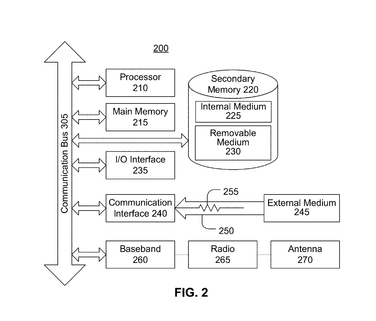
[0028]FIG. 2 is a block diagram illustrating an example wired or wireless system 200 that may be used in connection with various embodiments described herein. For example, system 200 may be used as or in conjunction with one or more of the m...


PUM


Abstract

Efficient and scalable three-dimensional point cloud segmentation. In an embodiment, a three-dimensional point cloud is segmented by adding points to a spatial hash. For each unseen point, a cluster is generated, the unseen point is added to the cluster and marked as seen, and, for each point that is added to the cluster, the point is set as a reference, a reference threshold metric is computed, all unseen neighbors are identified based on the reference threshold metric, and, for each identified unseen neighbor, the unseen neighbor is marked as seen, a neighbor threshold metric is computed, and the neighbor is added or not added to the cluster based on the neighbor threshold metric. When the cluster reaches a threshold size, it may be added to a cluster list. Objects may be identified based on the cluster list and used to control autonomous system(s).

Description

CROSS-REFERENCE TO RELATED APPLICATIONS[0001]This application claims priority to U.S. Provisional Patent App. No. 62 / 653,438, filed on Apr. 5, 2018—the entirety of which is hereby incorporated herein by reference.BACKGROUNDField of the Invention[0002]The embodiments described herein are generally directed to three-dimensional (3D) point cloud segmentation, and, more particularly, to an efficient and scalable clustering algorithm for 3D point cloud segmentation, for example, in the context of autonomous vehicles (e.g., for navigation).Description of the Related Art[0003]Any autonomous vehicle requires sensing and processing to understand its environment so that it can safely navigate the world. This requires an understanding of where the free space is within the vehicle's environment, which, in turn, requires an understanding of what objects are within the environment and where those objects are located within the environment. This sensing of the vehicle's environment is typically do...

Claims


Application Information

Patent Timeline
Patent Type & Authority Applications(United States)
IPC IPC(8): G01S17/93G06T7/136G06T7/187G05D1/02G01S17/931G01S13/931G01S17/89
CPCG06T7/136G05D1/024G06T7/187G01S17/936G06T2207/10028G05D2201/0213G06T2207/30252G01S17/89G01S2013/9318G01S2013/9319G01S2013/93185G01S17/931G06T7/11G01S13/931G01S13/89
Inventor HO, CHRISTOPHER
Owner APEX AI INC
Why Eureka
Try Eureka