Cooperative Aircraft Navigation

a technology of cooperative aircraft and navigation, applied in the direction of instruments, process and machine control, image enhancement, etc., can solve the problems of degraded, partially unavailable, or inability to provide absolute location information, and achieve the effect of improving back-end pose graph optimization, improving the optimization of pose graph and associated global pose estimates

Pending Publication Date: 2021-10-14
BRIGHAM YOUNG UNIV
View PDF3 Cites 3 Cited by
  • Summary
  • Abstract
  • Description
  • Claims
  • Application Information

AI Technical Summary

Benefits of technology

[0004]Two UASs may share range information to improve back-end pose graph optimization. A first UAS may obtain a range measurement to a second UAS, may share the range measurement with the second UAS, and both UASs may then perform a coordinated reset as described above. As part of the coordinated reset, and in in addition to adding a delta-pose edge to the respective global odometry pose graphs, each UAS may add an edge and node to incorporate the range measurement as a constraint. In one embodiment, each UAS may add at least as much of the other UAS's pose graph is may be necessary to provide an global anchor / linking point. Sharing range information may improve pose graph optimization and associated global pose estimates.

Problems solved by technology

One difficulty that has been encountered is navigation of fixed-wing UASs in environments where absolute location information SPS is unavailable, partially unavailable, or degraded.

Method used


Image

  • Cooperative Aircraft Navigation
  • Cooperative Aircraft Navigation
  • Cooperative Aircraft Navigation

Examples


Embodiment Construction

[0020]This Application claims priority to U.S. Provisional. Application No. 63 / 008,462, filed on Apr. 10, 2020, the first inventor of which is Gary Ellingson, and which is titled “Cooperative Rel ye Navigation of Multiple Aircraft in GPS-Denied / Degraded Environment.”

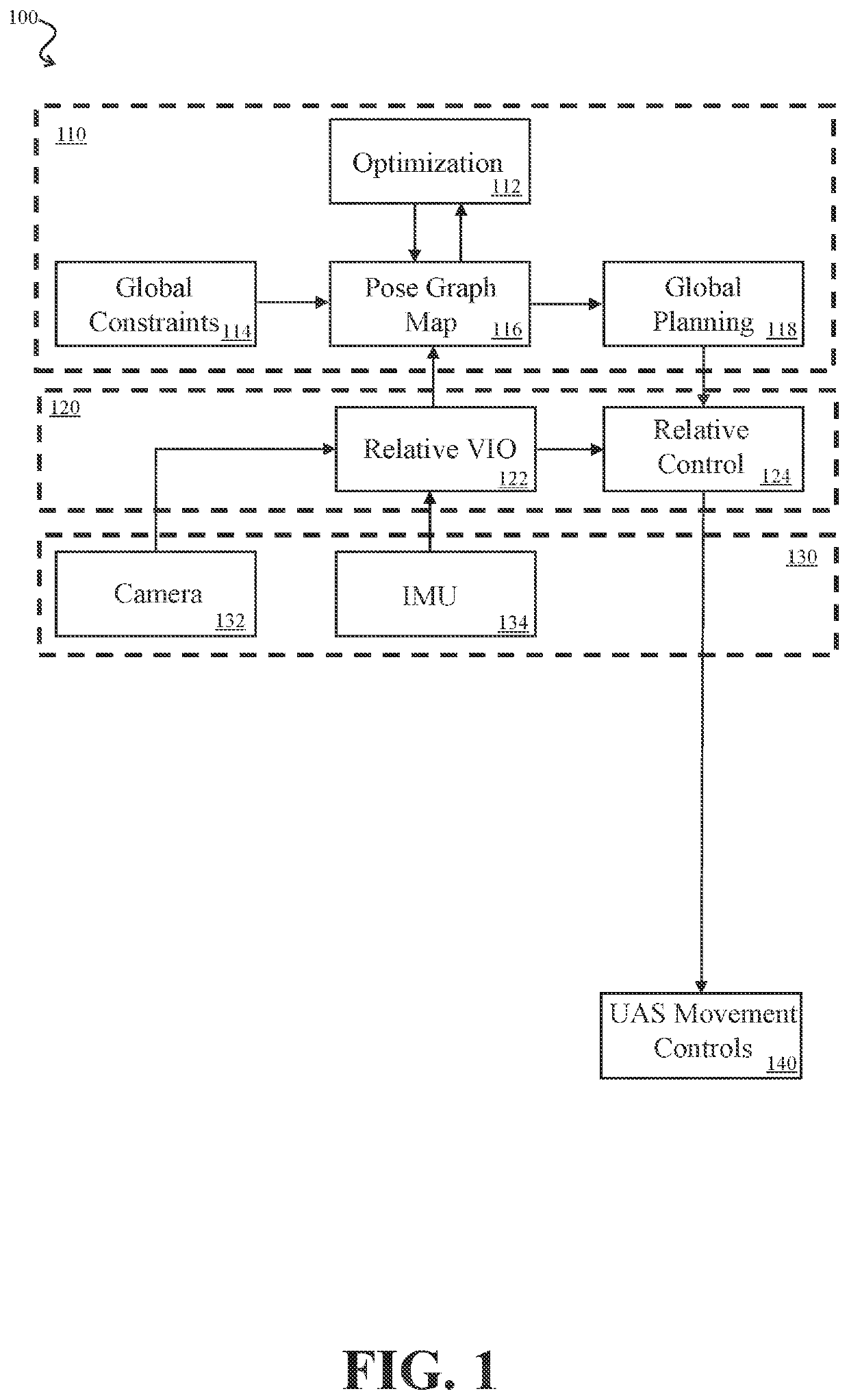
[0021]An improved system and method for navigation of fixed-wing UASs GPS-denied or GPS-degraded environments is disclosed.

[0022]Table of Reference Numbers from Drawings:

[0023]The following table is for convenience only, and should not be construed to supersede any potentially inconsistent disclosure herein.

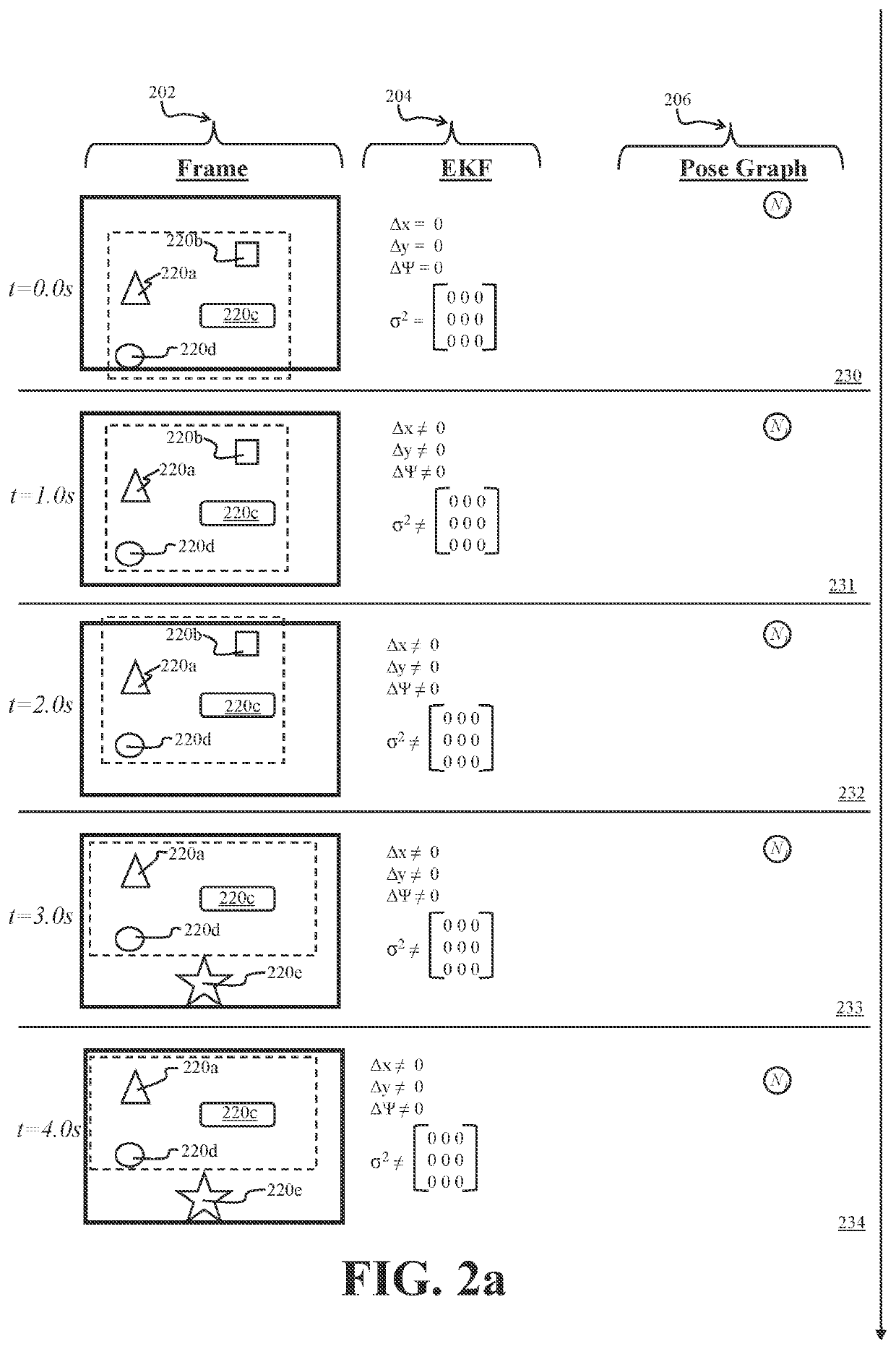
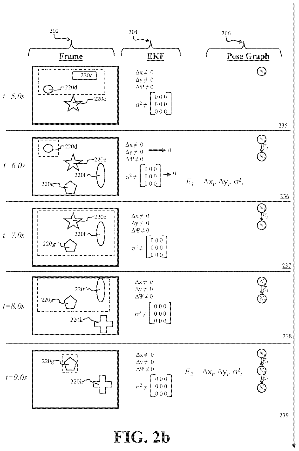
ReferenceNumberDescription100UAS (unmanned aircraft system)110Block diagram of exemplary navigation system120front end122VIO module124Relative control module130Sensor module202Camera frame column204EKF column206Pose graph column  220a-nIdentified features230Row for t = 0.0 s231Row for t = 1.0 s232Row tor t = 2.0 s233Row for t = 3.0 s234Row for t = 4.0 s235Row for t = 5.0 s236Row for t = 6.0 s237Row for t = 7.0 s238Row...


PUM


Abstract

A UAS may use camera-captured ground feature data to iteratively estimate pose change through a Kalman filter. To avoid excessive drift, the UAS may periodically perform a reset by publishing delta pose and covariance as an edge in a global pose graph, by zeroing out the delta pose and covariance. To further improve global pose estimation, two UASs may share range information and associated pose graph information, thereby providing an additional constraint for each UAS to use in its pose graph optimization.

Description

BACKGROUND OFTHE IN TENTION[0001]In recent years, unmanned aircraft systems (“UAS”) (a.k.a. “unmanned aerial vehicles,”“UAVs,”“drones,” etc.) have become widely used in a wide array of military and civilian applications.[0002]UAS technologies have also continued to develop. One difficulty that has been encountered is navigation of fixed-wing UASs in environments where absolute location information SPS is unavailable, partially unavailable, or degraded. What is needed is an improved system and method for navigation of fixed-wing UASs in a GPS-denied GPS degraded environment.BRIEF SUMMARY OF THE INVENTION[0003]A UAS may use a front-end nodule to estimate relative pose change, and may periodically publish the relative pose change to a back-end module for use in generating, modifying, updating, and optimizing a global pose model. In one embodiment, the front-end relative pose model may be an extended Kalman filter that may be iteratively updated based on ground features identified and t...

Claims


Application Information

Patent Timeline
Patent Type & Authority Applications(United States)
IPC IPC(8): G06T7/246G06T7/277G06T7/73B64D47/08G08G5/00G01C21/20G05D1/10
CPCG06T7/248G06T7/277G06T7/73G06T7/251B64D47/08G06T2207/20072G08G5/0008G01C21/20G05D1/101G06T2207/10032G06T2207/30181G08G5/0069G05D1/0202
Inventor ELLINGSON, GARYMCLAIN, TIMOTHYBRINK, KEVIN
Owner BRIGHAM YOUNG UNIV
Why Eureka
Try Eureka