Method and apparatus for global positioning system based cooperative location system

a technology of global positioning system and location system, applied in direction finders, instruments, measurement devices, etc., can solve problems such as the inability of users to determine direction

Inactive Publication Date: 2000-03-28
RAYTHEON CO
View PDF20 Cites 107 Cited by
  • Summary
  • Abstract
  • Description
  • Claims
  • Application Information

AI Technical Summary

Problems solved by technology

However, the United States Government imposes pseudo-random errors (referred to as selective availability ("S / A") random errors) into the location data provided by the satellites.
Therefore, due to this introduced error, existing C / A code GPS based navigation aids provide a low resolution direction to a fixed point on the earth, i.e. a waypoint, with only an approximation range to the desired location.
Until the user moves, however, there is no way for the user to determine the direction that they are going because GPS provides only an instantaneous position.

Method used


Image

  • Method and apparatus for global positioning system based cooperative location system
  • Method and apparatus for global positioning system based cooperative location system
  • Method and apparatus for global positioning system based cooperative location system

Examples


Embodiment Construction

The invention encompasses using GPS and an electronic magnetic compass for relative navigation (RGPS) without external aids or site surveys. It also includes a method of performing RGPS at very low (truncated) data rates.

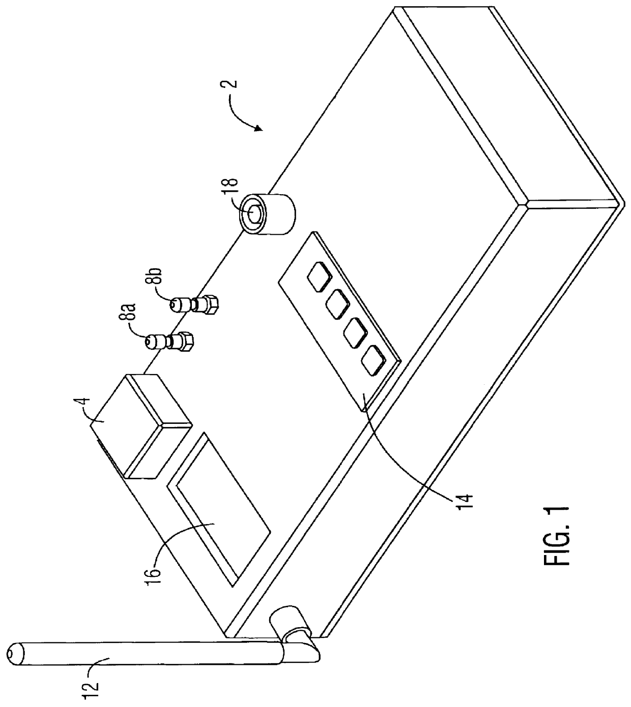
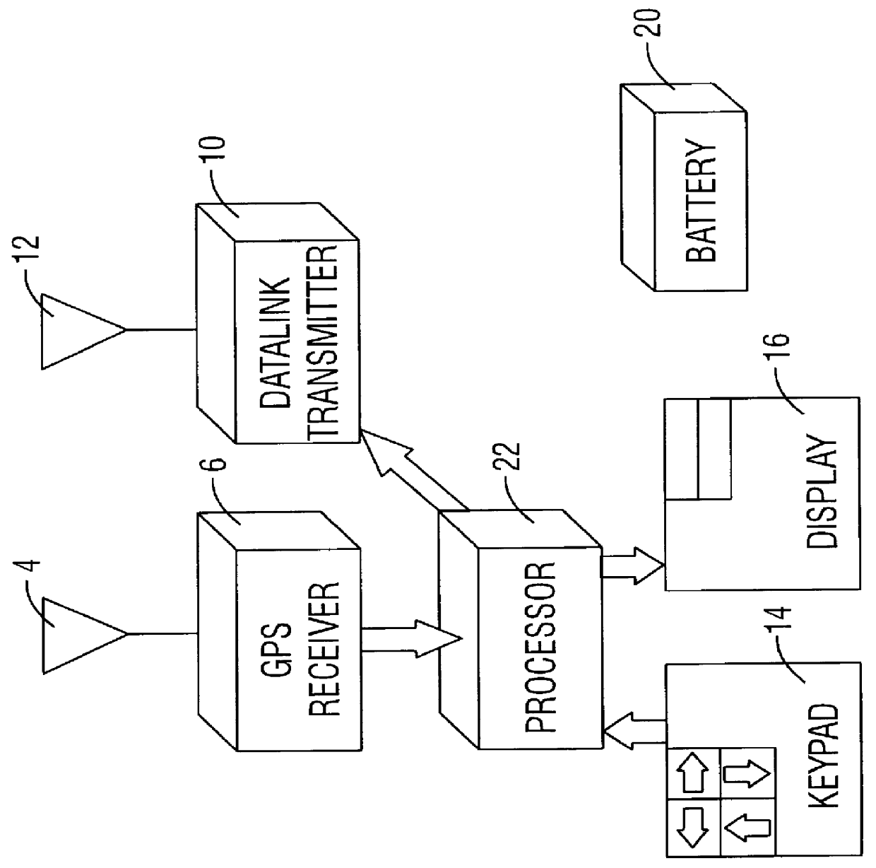
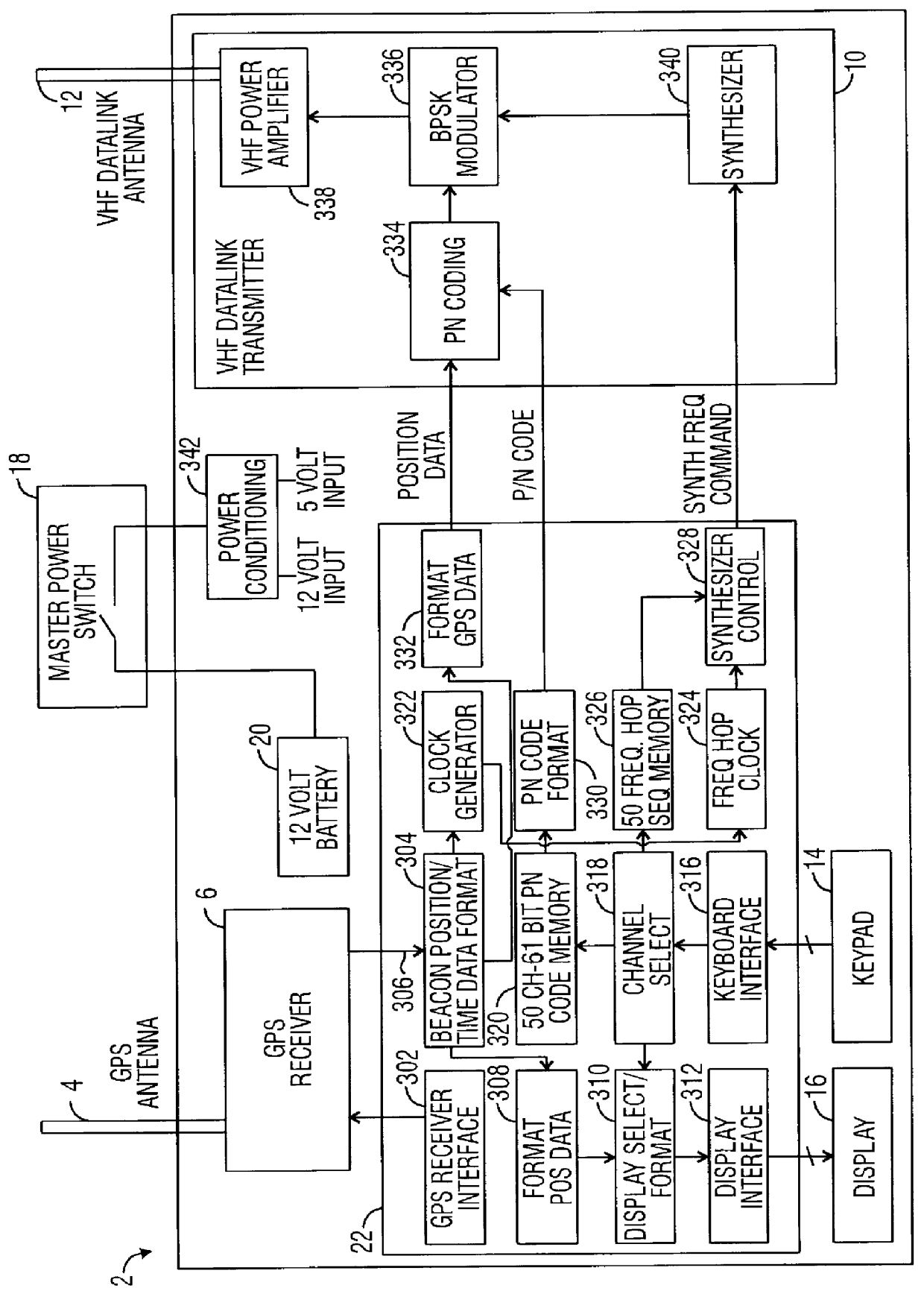
The invention is designed, and has been operationally demonstrated, to be comprised of one or more beacons, and one or more locators that in concert provide the locator both the range and direction to the cooperative beacons on a given data transmission channel. In operation, a beacon determines its GPS position and the identification of the satellites that were used in the calculation, and compresses and transmits that data over a non-line of sight RF data link to the locator. A locator independently determines its GPS position and the satellites used in the position calculation, and compares that data to the received beacon position and satellite identification. The difference between the beacon and locator position data provides sufficiently accurate range and be...


PUM


Abstract

A cooperative location system for use with a Global Positioning System ("GPS"). The system includes a beacon that receives GPS signals and transmits GPS data representing the location of the beacon to a remote locator. The locator receives the beacon's GPS data from the beacon. Based on the beacon's GPS data, a reference direction provided by a compass, and the locator's own GPS data, the locator calculates range and direction information to the beacon.

Description

1. Field of the InventionThe present invention relates to a location system for locating a cooperative beacon. More particularly, it concerns a location system based on Global Positioning System ("GPS") technology that permits accurate range and direction detection of a cooperative beacon using relative GPS ("RGPS") differential range and direction.2. Description of Related ArtThe Global Positioning System ("GPS") presently consists of a constellation of 24 satellites that continuously broadcast time and frequency data on two frequencies, L1 and L2. GPS receivers have been developed that can determine a precise location on the earth by measuring the time required for the signals of three, or preferably four or more, of the satellites to reach the location on earth. Using these measurements and triangulating, the GPS receiver's position may be calculated. The GPS receiver provides position information in the form of X, Y, and Z axes coordinates measured in meters from the center of t...

Claims


Application Information

Patent Timeline
Patent Type & Authority Patents(United States)
IPC IPC(8): G01S1/00G01S1/68G01S5/00G01S5/14G01S19/17
CPCG01S1/68G01S5/0045G01S19/51G01S2205/006
Inventor BERGMAN, JULIAN J.KENNETT, SCOTT W.ROTHS, JOHN D.THORUP, KARL L.
Owner RAYTHEON CO
Why Eureka
Try Eureka