Method and system for high precision altitude measurement over hostile terrain

a high-precision, altitude measurement technology, applied in the field of altitude measurement, can solve the problems of carrying significant risk in hostile territory, method does not measure altitude, military aircraft operating in hostile or enemy territory cannot expect to obtain or depend on reliable barometric information from local airports in hostile territory

Inactive Publication Date: 2002-10-08
INNOVATIVE SOLUTIONS & SUPPORT
View PDF8 Cites 49 Cited by
  • Summary
  • Abstract
  • Description
  • Claims
  • Application Information

AI Technical Summary

Problems solved by technology

Conventionally, when measuring AGL altitude, aircraft use radar altimeter readings which are detectable and, hence, carry significant risk in hostile territory.
However, enemy ground monitors may detect the radar altimeter beam and initiate anti-aircraft measures to intercept and destroy the aircraft.
However, this method does not measure AGL altitude, so the combat pilot is still left with an unknown error correction representing the height of the aircraft above the terrain, and / or other obstacles (e.g. buildings).
There is yet another problem with relying on static air pressure as a determinant of the AGL altitude of the aircraft.
Obviously, however, military aircraft operating in hostile or enemy territory cannot expect to obtain or depend on reliable barometric information from local airports in the hostile territory.

Method used


Image

  • Method and system for high precision altitude measurement over hostile terrain
  • Method and system for high precision altitude measurement over hostile terrain
  • Method and system for high precision altitude measurement over hostile terrain

Examples


Embodiment Construction

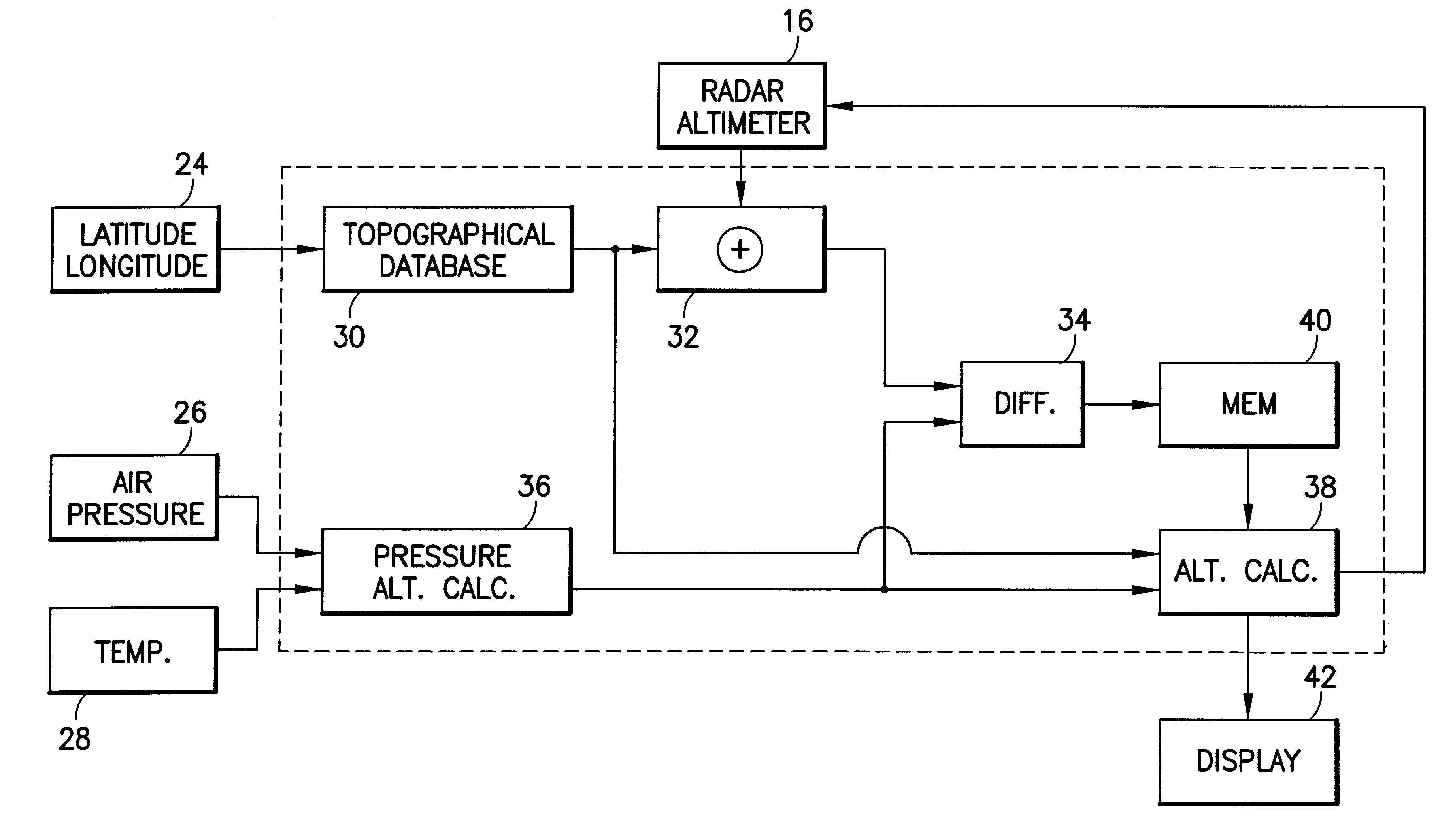
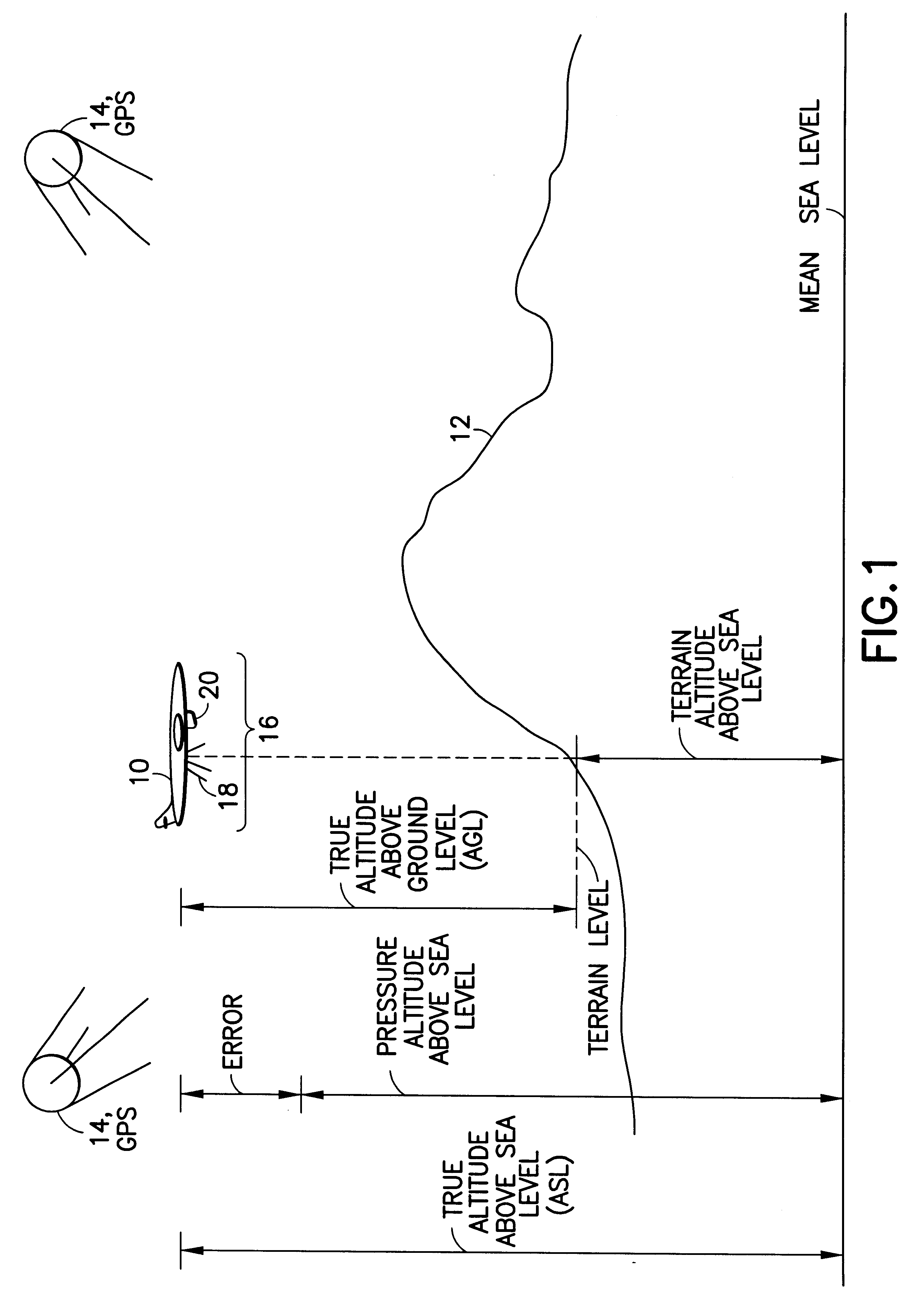
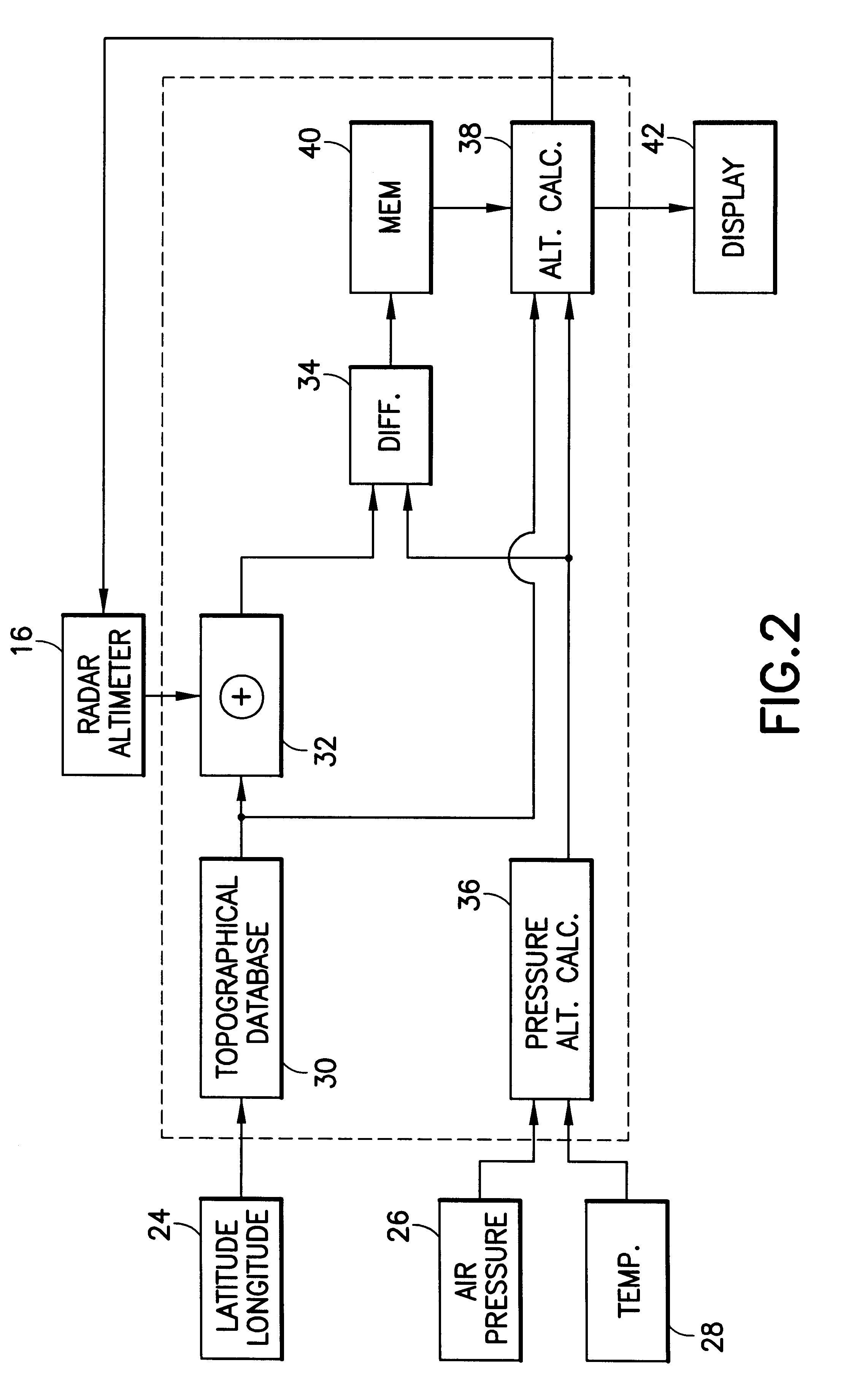
FIG. 1 depicts an aircraft 10 in flight over terrain 12. For purposes of discussion it is presumed that aircraft 10 is a military aircraft flying over hostile terrain. The invention is nevertheless equally operable in other situations, and the invention and its application should not therefore be construed as being limited to a military aircraft.

When flying over hostile terrain, highly accurate altitude measurement is crucial. While the use of known radar altimeters provides a highly reliable method of determining altitude, such use is easily detectable and, therefore, undesirable. To compensate or minimize this drawback, it is customary for a military aircraft to reduce the generation of radio frequency (RF) waves emitted from such altimeters.

Altitude is typically measured relative to a constant or static air pressure value sensed at the exterior skin of the aircraft. The actual air pressure about an aircraft, however, is not only affected by altitude but also by air temperature an...


PUM


Abstract

A system and method for providing highly accurate measurements of the altitude above ground level (AGL) of an aircraft flying over local terrain. A current AGL altitude of the aircraft over local terrain is obtained by activating a radar altimeter on the aircraft for a single short duration or pulse. A mean sea level (MSL) elevation of the local terrain is determined by identifying the terrain from the then-current aircraft geographical position coordinates and utilizing known terrain topography data. The actual MSL altitude of the aircraft can then be determined. An uncorrected MSL altitude of the aircraft is then determined from conventional static air pressure measurements and the difference between the actual MSL altitude and the uncorrected MSL altitude of the aircraft yields a local barometric correction factor for use in determining MSL altitude measurements of the aircraft as the aircraft flies over and continues its flight away from the local terrain.

Description

1. Field of the InventionThis invention relates to the field of altitude measurement and, more particularly, to high precision altitude measurement for use by aircraft.2. Description of the Related ArtFor obvious reasons, it is important to accurately know, at all times, the altitude of an aircraft in flight. The importance is raised by an order of magnitude in the field of military aircraft, where the altitude may need to be measured and known to very strict tolerances under hostile conditions. Military aircraft often travel surreptitiously, and have special needs for highly accurate measurements of their current altitude above ground level ("AGL").Conventionally, when measuring AGL altitude, aircraft use radar altimeter readings which are detectable and, hence, carry significant risk in hostile territory. Radar altimeters operate by emitting a radar beam, either continuous or pulsed at close time intervals. The beam is directed from the in-flight aircraft toward underlying local t...

Claims


Application Information

Patent Timeline
Patent Type & Authority Patents(United States)
IPC IPC(8): G01C5/00G01S13/00G01S13/88
CPCG01C5/005G01S13/882
Inventor HEDRICK, GEOFFREY S. M.
Owner INNOVATIVE SOLUTIONS & SUPPORT
Why Eureka
Try Eureka