Method for determining the co-ordinates of a satellite

a satellite and coordinate technology, applied in the field of satellite coordinate determination, can solve the problems of low response speed, complex and costly processors, and high computational cost of procedures

Inactive Publication Date: 2003-05-20
SAMSUNG ELECTRONICS CO LTD
View PDF7 Cites 34 Cited by
  • Summary
  • Abstract
  • Description
  • Claims
  • Application Information

AI Technical Summary

Problems solved by technology

The known methods of determination if the current coordinates of the SRNS satellite based on the prediction (extrapolation) of the orbital motion are characterized by a high cost of computational procedures (complex and costly processors are used) and a low speed of response.
A specific feature of the method [2] is that the same algorithm of evaluations is used at any instant, and since the calculations are made in a full scope at each instant of time, the speed of response of this method is also low.
A similar disadvantage may be found n the method

Method used


Image

  • Method for determining the co-ordinates of a satellite
  • Method for determining the co-ordinates of a satellite
  • Method for determining the co-ordinates of a satellite

Examples


Embodiment Construction

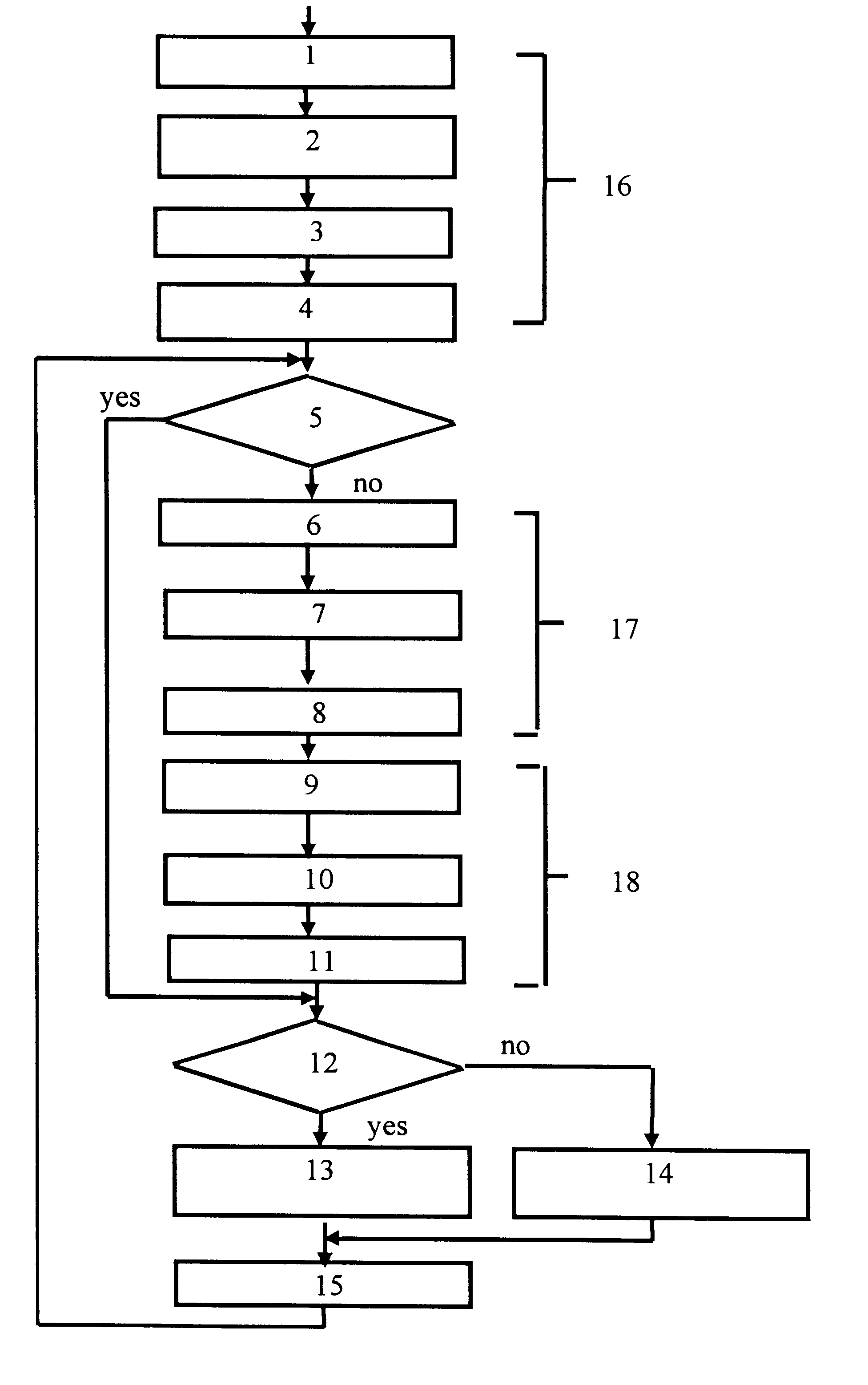
According to the claimed method, the current points of an orbital position (coordinates) of the SRNS satellite are determined as shown in the block diagram of the computational algorithm (FIG. 1) illustrating an example of the successive steps and interconnection of the operations.

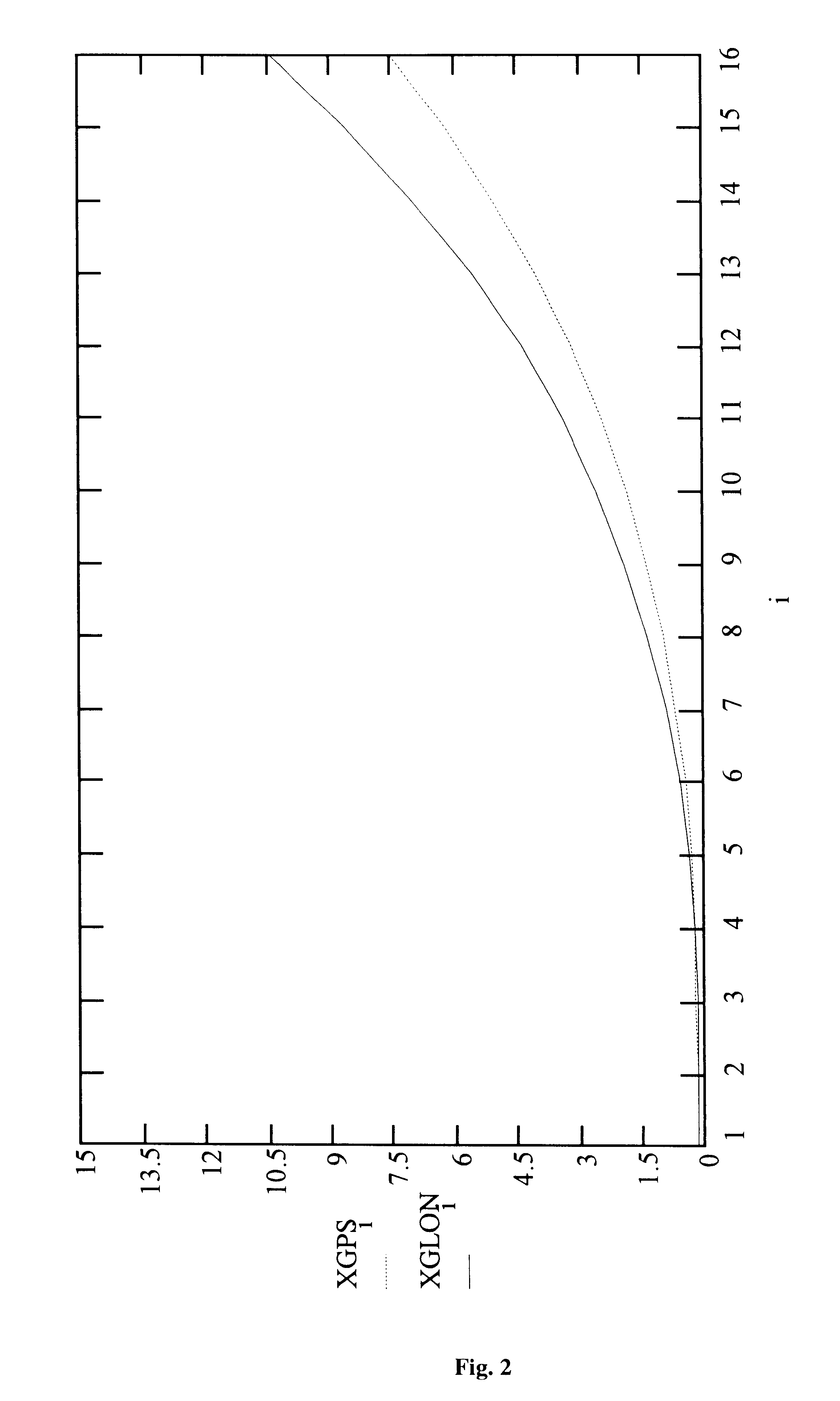
The calculation of the ephemeredes for each working satellite is effected by steps of 0.5-1.0 seconds in a time interval of 0.5 hours (the time of change of the ephemeredes) for the SRNS GLONASS satellite and of up to 1.0-2.0 hours for the SRNS GSP satellite.

The satellite coordinates are calculated in a time interval starting from some initial moment t.sub.start. The first nodal point is assigned for an instant t.sub.start, the next one for t.sub.start +t.sub.int. Using the a priori known ephemeredes at the initial instants of time (t=t.sub.start), the predicted position of the satellite on the orbit (the coordinates X.sub.s and velocity speed V.sub.s) at defined nodal points (t=t.sub.y) spaced one from an...


PUM


Abstract

The invention relates to the field of radio navigation and, more specifically, it relates to methods of determining the current values of the orbital position of the artificial satellite of the Earth which is used in a satellite radio navigation system (SRNS), by the ephemeredes and can be used when performing the radio navigation measurements in the equipment of the consumers of the SRNS signals. The variants of a fast method for determining the coordinates of the satellite are proposed, which consist in that the satellite coordinates are determined at preset points of the orbit spaced from each other by a selected time interval, and further determining the velocities of the satellite at the nodal points, while at the points between the nodal points the satellite coordinate are determined in the geocentric inertial system of coordinates are in a system the Greenwich geocentric coordinates using special formulas or the Taylor polynomial of the second or third order, and determining these at the nodal points using the six-order Taylor polynomial.

Description

The invention relates to the field of radio navigation and, more specifically, the invention relates to the methods for determining the current values of the orbital position of the artificial satellite of the Earth operating in a satellite radio navigation system (SRNS) by the ephemeredes, and can be used for performing the radio navigation measurements in the equipment of the users of the SRNS signals.PRIOR ARTIt is well known, that the navigational receivers in the equipment of the users of the SRNS GPS and / or GLONASS signals, determine their coordinates and speed using the quasi-range and quasi-velocity measurements relative to the current position (coordinates) of satellites on orbit (cf. Network Satellite Radio Navigation Systems, V. S. Sebshaevich, P. P. Dmitriev, N. V. Ivantsevich et al., Moscow, Radio i Svyaz publishers, 1993, pages 110-114, FIG. 7.3) [1]. The current values of the coordinates of the satellites at the moments of measurements are calculated in the receiver. ...

Claims


Application Information

Patent Timeline
IPC IPC(8): B64G3/00B64G1/10B64G1/00G01S5/02G01S5/14G01C21/24G01B21/00G01C21/04G01C21/12G01C21/20G01S1/00G01S19/24G01S19/27G08G1/0969
CPCB64G1/1014B64G3/00G01S19/27G01S19/24G01S5/02G01C21/12
Inventor ROG, ANDREY LEONIDOVICHKAKOSHKINA, NATALIA P.IVANOV, VLADIMIR N.TZEKHANOVICH, GENNADY S.MALASHIN, VIKTOR I.PISAREV, SERGUEY B.POVERENNYI, DENIS G.SHEBSHAEVICH, BORIS V.SILIN, MIKHAIL YU.
Owner SAMSUNG ELECTRONICS CO LTD
Why Eureka
Try Eureka