Method and system for limited frequency seismic imaging

a limited frequency and seismic imaging technology, applied in the field of limited frequency seismic imaging, can solve the problems of large computation costs for three-dimensional geophysical data processing and/or modeling, affecting data processing considerations, analysis time and cost, etc., and achieve the effect of reducing computation resources

Active Publication Date: 2005-02-22
PARADIGM GEOPHYSICAL CORP
View PDF2 Cites 58 Cited by
  • Summary
  • Abstract
  • Description
  • Claims
  • Application Information

AI Technical Summary

Benefits of technology

The method and system of the present inventions provides a new approach for selecting frequencies comprising a minimal or limited frequency data set for imaging leading to an order of magnitude decrease in computation resources. Seismic data are acquired and transformed a frequency domain. The data may be gathered in any manner. A plurality of minimal frequency subsets are formed

Problems solved by technology

Unfortunately, three dimensional geophysical data processing and/or modeling frequently require large computation expenses, and practitioners are forced to simplify the data processing effort as much as possible to reduce analysis time and cost.
The sheer volume of data impacts data processing considerations.
Compromises often required during data acquisition and processing can result in ambiguous and/or inaccurate subsurface images.
Because little is gener

Method used


Image

  • Method and system for limited frequency seismic imaging
  • Method and system for limited frequency seismic imaging
  • Method and system for limited frequency seismic imaging

Examples


Embodiment Construction

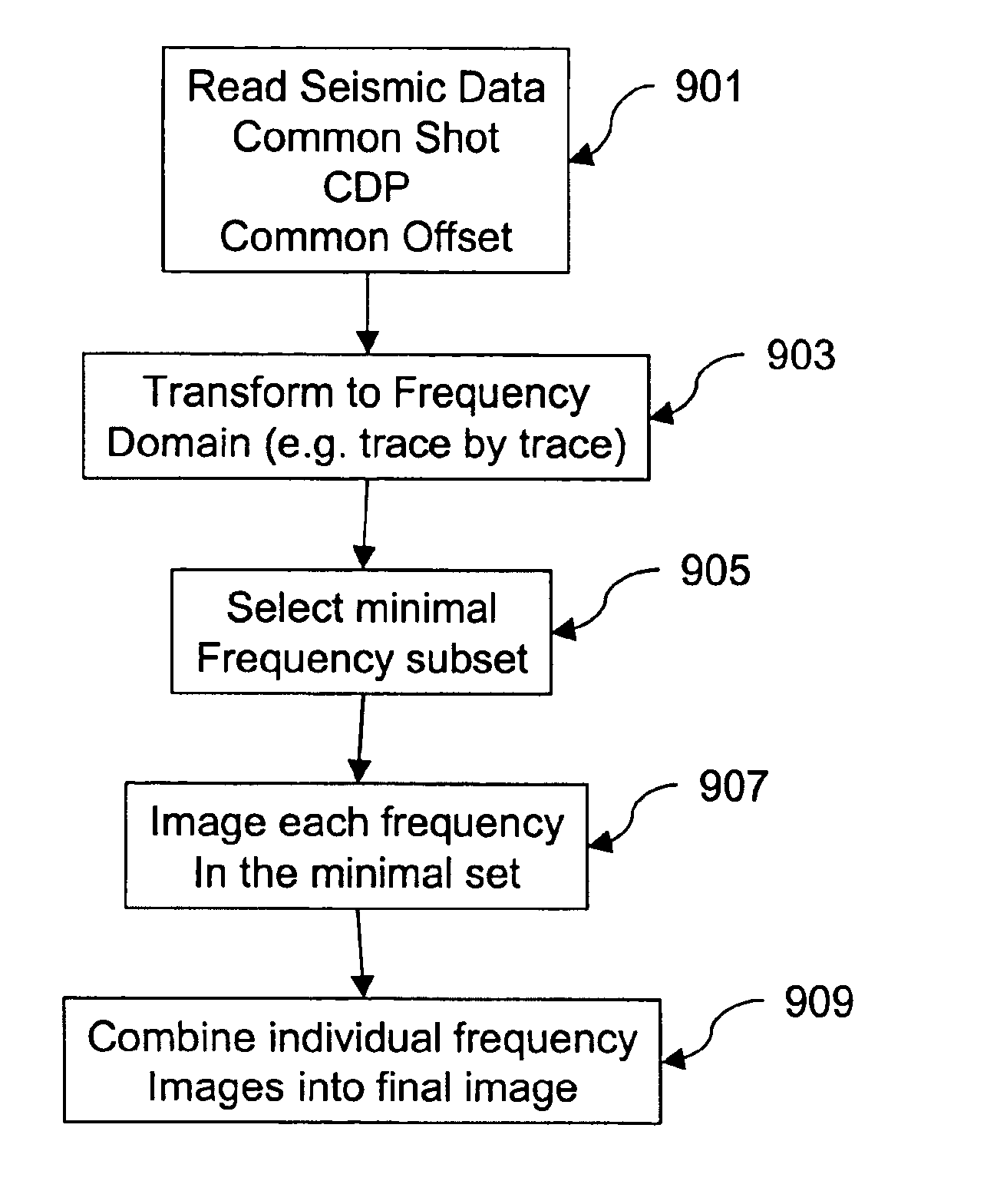
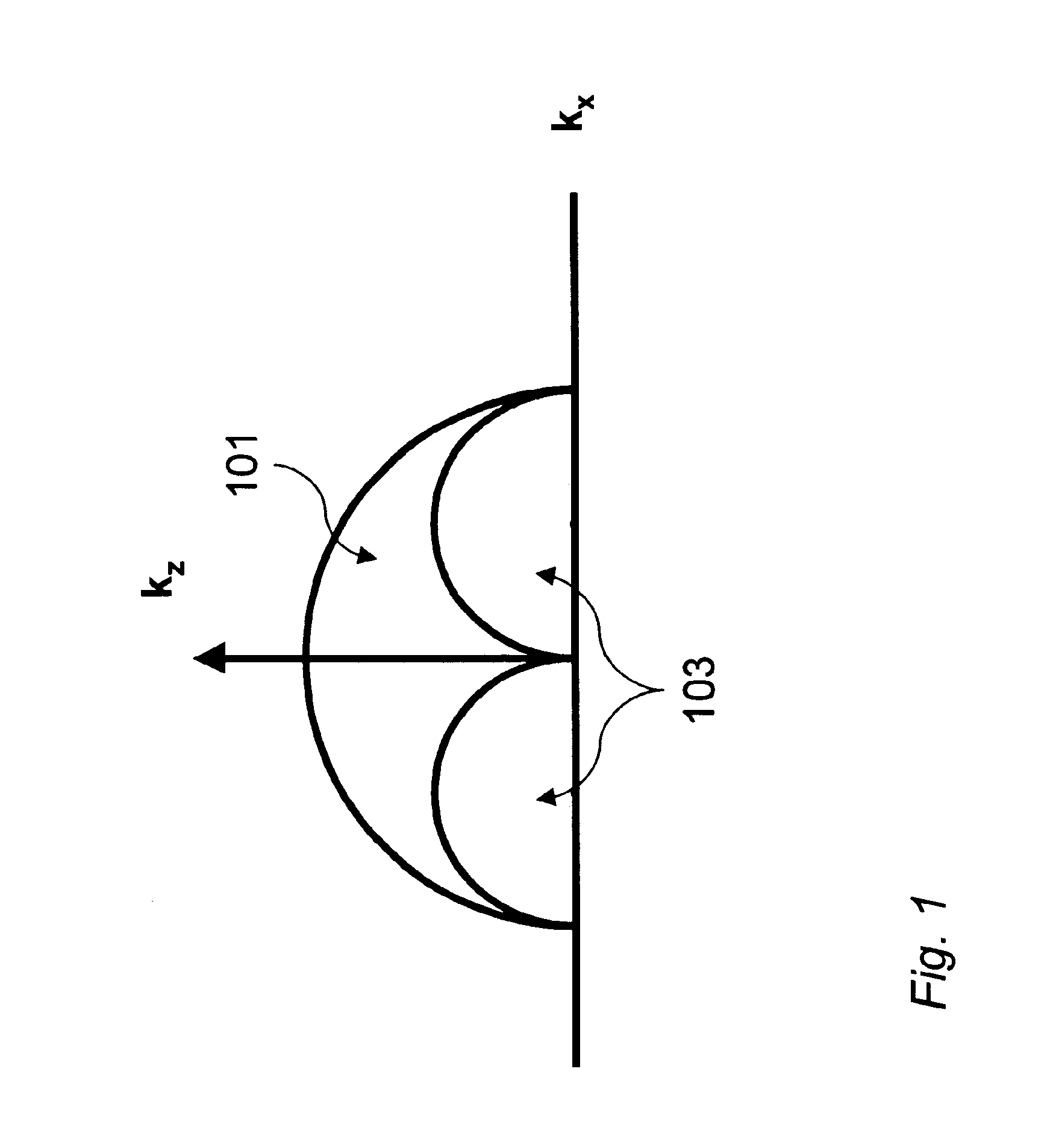
Zero-offset-migration / inversion of single frequency data produces a subsurface image with spatial wavenumbers confined to an Ewald sphere defined by a simple dispersion relation. For non-zero-offset, the Ewald sphere becomes an Ewald doughnut. A single frequency images a wavenumber volume rather than just a spherical shell. This fact can be exploited to substantially reduce the number of frequencies needed to accurately map subsurface reflectors. This invention provides a method and apparatus for calculating a sparse set of frequencies for use in frequency-slice migration algorithms. The migration process remains the same, but the smaller set of frequencies results in an algorithm an order of magnitude faster than more traditional implementations. A small collection of case studies compares the limited frequency approach to traditional methods. Finally, we discuss various strategies for parallel implementation in distributed computational environments.

The standard approach to freque...


PUM


Abstract

The method and system of the present inventions provides a new approach for selecting frequencies comprising a minimal or limited frequency data set for imaging leading to an order of magnitude decrease in computation resources. Seismic data are acquired and transformed a frequency domain. The data may be gathered in any manner. A plurality of minimal frequency subsets are formed comprising selected frequencies. The frequencies may be selected so that more frequencies are selected for shallower image positions. The selected frequencies are imaged to form frequency images. The selected frequencies may be individually weighted to assure a full and balanced bandwidth. The frequency images are composited to form an intermediate or final composited migration image.

Description

FIELD OF THE INVENTIONThis invention relates to the field of seismic data processing and, more particularly, to the use migration for determining subsurface earth structure represented by a 3-D volume of data for identifying structural and stratigraphic features in three dimensions.BACKGROUND OF THE INVENTIONSearching for subsurface mineral and hydrocarbon deposits comprises data acquisition, analysis, and interpretation procedures. Data acquisition involves energy sources generating signals propagating into the earth and reflecting from subsurface geologic structures. The signals received are recorded by receivers on or near the surface of the earth. The received signals are stored as time series (seismic traces) that consist of amplitudes of acoustic energy which vary as a function of time, receiver position, and source position and, most importantly, vary as a function of the physical properties of the structures from which the signals reflect. The data are generally processed to...

Claims


Application Information

Patent Timeline
IPC IPC(8): G01V1/28
CPCG01V1/28
Inventor BEDNAR, J. BEE
Owner PARADIGM GEOPHYSICAL CORP
Why Eureka
Try Eureka