Extensible navigation systems

a navigation system and expansion technology, applied in the field of navigation systems, can solve the problems of limited navigation quality, limited supply of navigation quality data, and limitations of stand-alone systems

Inactive Publication Date: 2006-05-09
INFOGATION CORP
View PDF3 Cites 73 Cited by
  • Summary
  • Abstract
  • Description
  • Claims
  • Application Information

AI Technical Summary

Problems solved by technology

Such standalone systems, however, are constrained by the content and volume of the map database that, due to space limitations, might not include dynamic characteristics of the road network such as the effect of traffic, weather, or other road conditions.
Navigation quality is also limited by the relatively static nature of the database.
Furthermore, because of the generally proprietary nature of the map data, the end user usually only has a single source for the map data, and is therefore also subject to the limitations of the supplier's ability to generate navigation quality data.
While these services maintain the benefit of having a central map database, which can be kept up-to-date much more readily than standalone systems, the lack of direct local access to this central map database from the client device reduces the overall system functionality.
While a simple image is generally sufficient for rendering the image to a display device, it usually lacks sufficient additional information to enable it to be used for navigation purposes and connectivity information.
However, neither text instructions nor raster images can provide attribute or connectivity information for the road network.

Method used


Image

  • Extensible navigation systems
  • Extensible navigation systems
  • Extensible navigation systems

Examples


Embodiment Construction

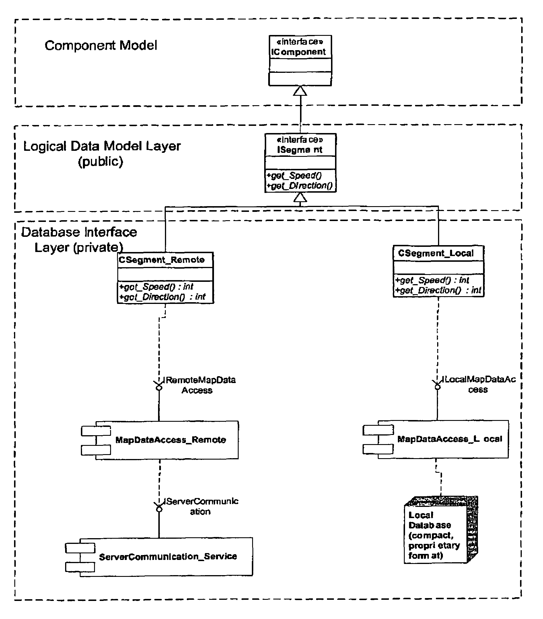
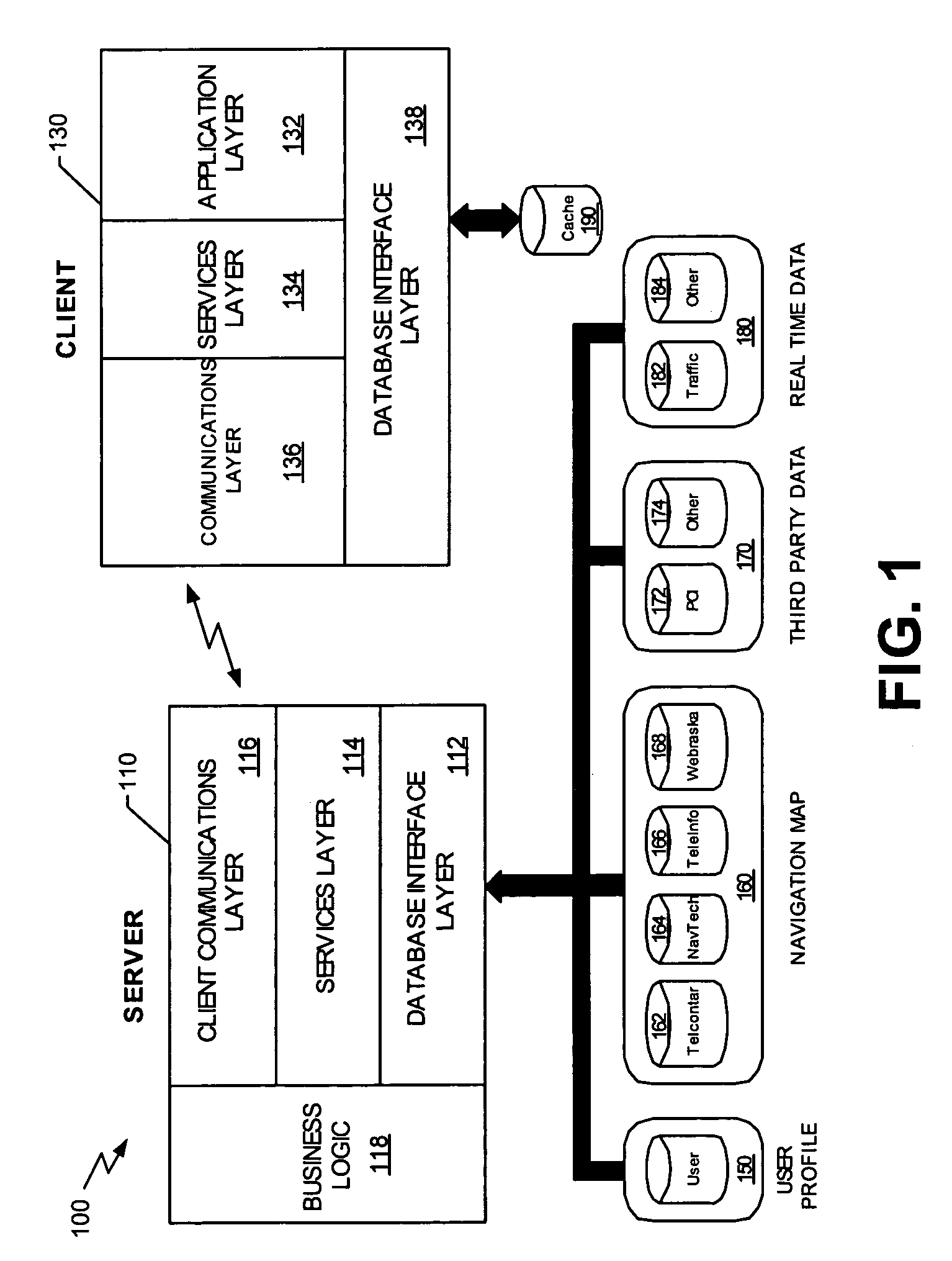
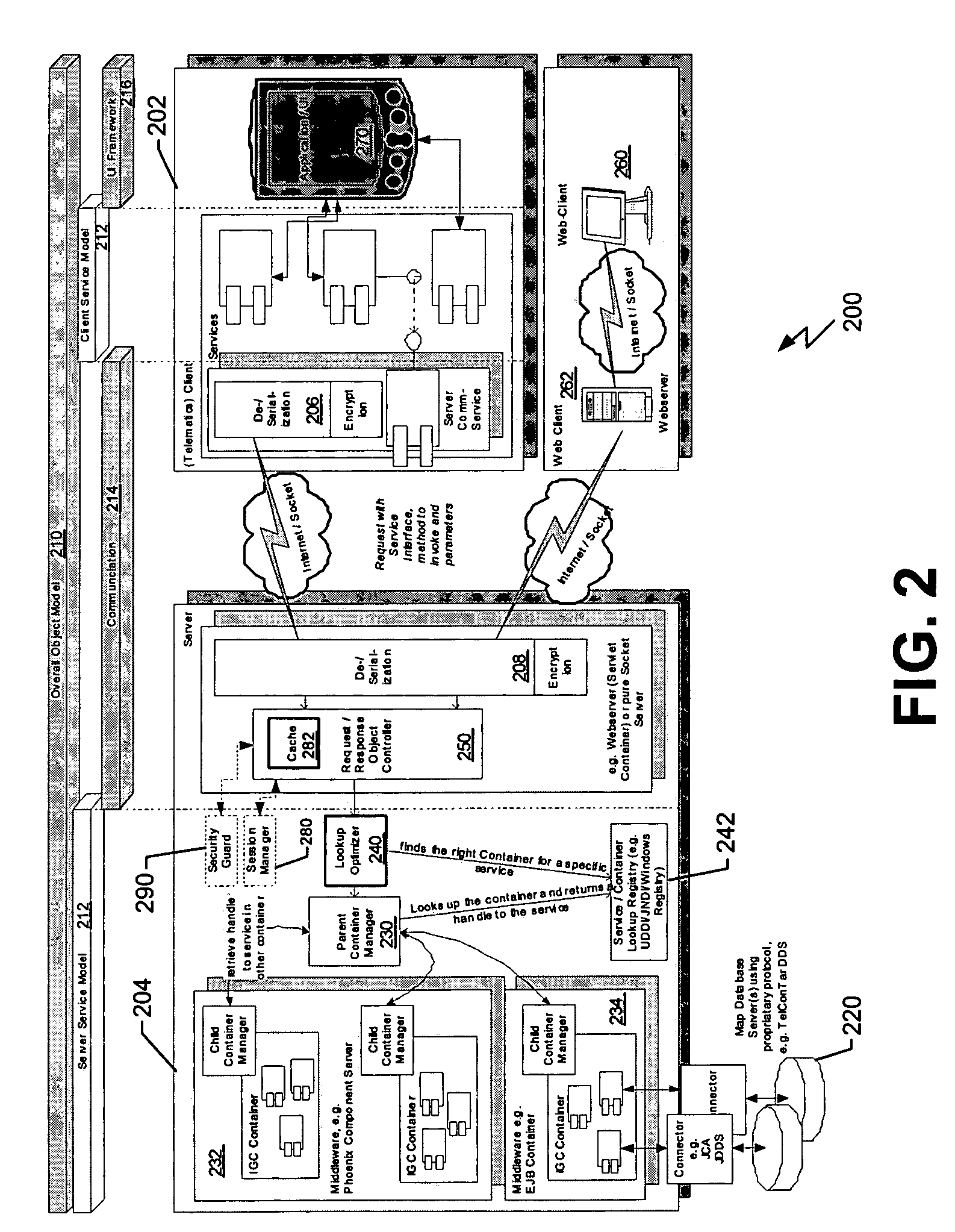
[0026]Exemplary embodiments are described for a distributed computing solution combining intelligent client devices with local caching, and with processing capabilities for wireless connectivity, and server systems that, in combination, provide a navigation system with expanded quality and functionality for services offered to mobile users. Aspects of the embodiments involve distributed navigation, system architecture, messaging protocol, high-level data management, and enhanced telematics services. In particular, the exemplary embodiments involve systems and techniques that provide services and functionality based on knowledge of the current and expected geographic location of the mobile device or user.

[0027]The exemplary embodiments of the distributed navigation system described herein provide the ability to combine an intelligent client with a back-end server system to the same functional performance, but richer functionality, than can be provided by a standalone navigation syste...


PUM


Abstract

Computer-assisted navigation is achieved with component-oriented programming and instructions that provide a distributed component programming navigation system. The computer-assisted navigation is achieved with a computing device including a logical data model configured to provide abstract interfaces in a process to convert a format and data model of a provider to an appropriate format and data model suitable for the computing device, wherein the process occurs on demand, only when needed, or the conversion occurs in accordance with the format and data model of the provider, and at download time or at an initial processing time. As a result, such a computing device can be advantageously used many environments including a distributed navigation system.

Description

REFERENCE TO PRIORITY DOCUMENT[0001]This application is a continuation of application Ser. No. 10 / 602,326, filed Jun. 23, 2003, now U.S. Pat. No. 6,978,206 claims the benefit of priority of U.S. Provisional Patent Application Ser. No. 60 / 389,447 entitled “Distributed Navigation System”, filed Jun. 21, 2002 and Ser. No. 60 / 390,484 entitled “Distributed Navigation Data Management System”, filed Jun. 21, 2002. Priority of the filing dates of Jun. 21, 2002 are hereby claimed, and the disclosures of the Provisional Patent Applications are hereby incorporated by reference.BACKGROUND[0002]1. Field[0003]The present invention relates generally to navigation systems and, more particularly, to wireless navigation information systems.[0004]2. Description of the Related Art[0005]With the introduction of greater geographic coverage and higher bandwidth wireless connections, wireless carriers and telematics service providers are expected to provide greater functionality and utility in their servic...

Claims


Application Information

Patent Timeline
Patent Type & Authority Patents(United States)
IPC IPC(8): G06F17/00G01C21/26
CPCG01C21/26Y10S707/99945
Inventor STANKOULOV, PAVELPU, KENT QING
Owner INFOGATION CORP
Why Eureka
Try Eureka