Method and system for direct classification from three dimensional digital imaging

a three-dimensional digital imaging and classification method technology, applied in the direction of reradiation, distance measurement, instruments, etc., can solve the problems of inability to produce repeatable visualization techniques, inability to interpret the resulting imagery with considerable time and effort (manual human intervention), and methods producing inadequate and inaccurate results

Inactive Publication Date: 2006-05-16
DOW JAMES W
View PDF4 Cites 140 Cited by
  • Summary
  • Abstract
  • Description
  • Claims
  • Application Information

AI Technical Summary

Benefits of technology

[0009]These needs and others may be met by the present invention having an aspect which is a method for processing digital image data taken from a three-dimensional topographic scene including terrain to extract discrete objects. Waypoints are located to define a centerline and a bounded area to be analyzed. The primary dimensional characteristics or attributes of the objects to be extracted from the image are defined. Finite element cells are defined having a width dependent on the area of interest, a length dependent on the dimension of...

Problems solved by technology

Today, however, considerable time and effort (manual human intervention) is required to interpret the resulting imagery and extract information suitable (e.g., in a more meaningful object-oriented form) for input to existing computer-based tools for map-making, 3D modeling for engineering analysis, land management, and/or asset management.
However, at the present time, there are only a few rudimentary approaches (usually based on simple data averaging or smoothing techniques or crude heuristic rules) for “filtering” or classifying three-dimensional point data to determine which subset of the points might be associated with a particular type of only a very few recognizable objects.
Such visualization techniques may not be able to produce repeatable results.
First, such methods produce inadequate and inaccura...

Method used


Image

  • Method and system for direct classification from three dimensional digital imaging
  • Method and system for direct classification from three dimensional digital imaging
  • Method and system for direct classification from three dimensional digital imaging

Examples


Embodiment Construction

[0022]While the present invention is capable of embodiment in various forms, there is shown in the drawings and will hereinafter be described a presently preferred embodiment with the understanding that the present disclosure is to be considered as an exemplification of the invention, and is not intended to limit the invention to the specific embodiment illustrated.

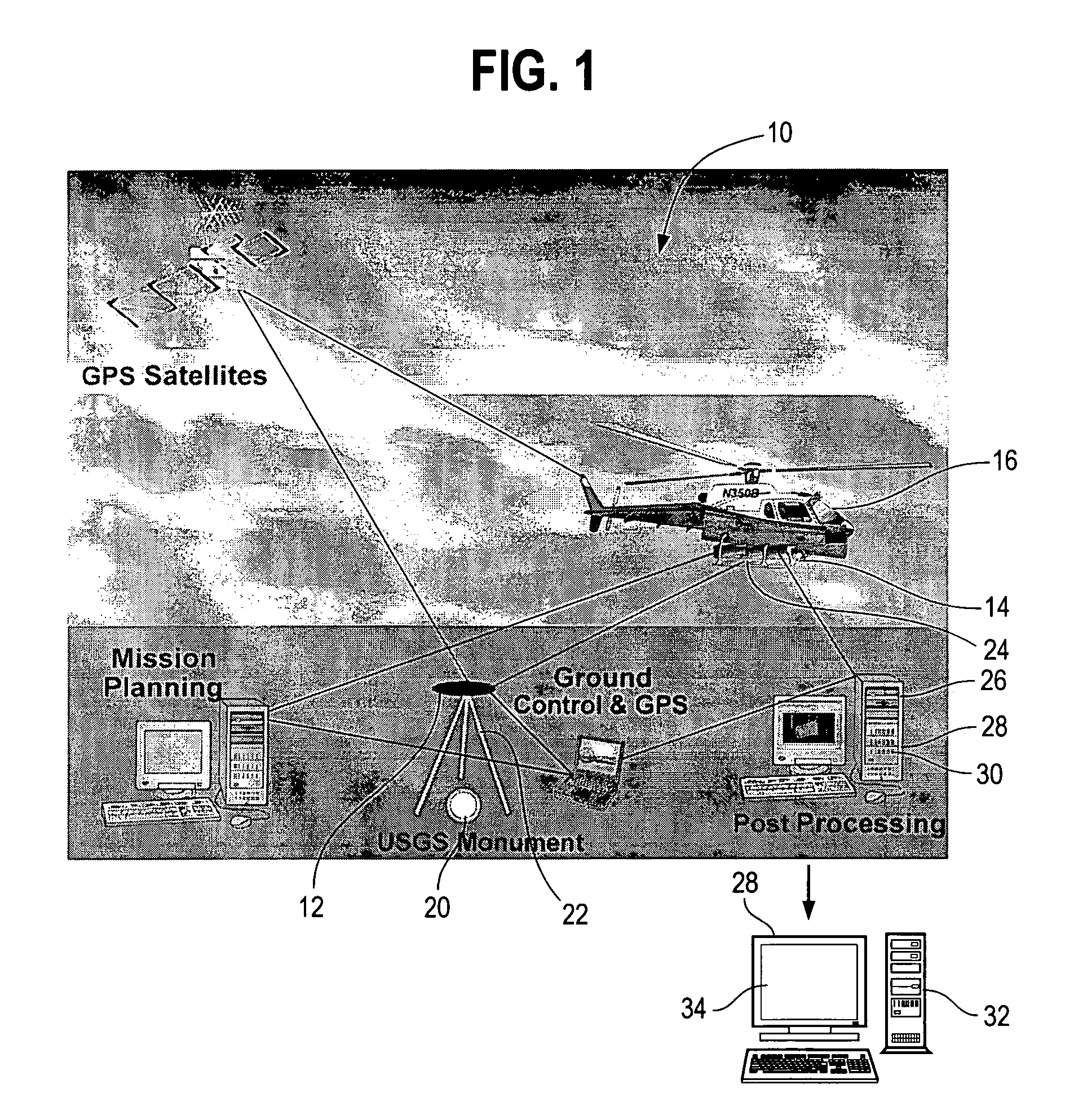
[0023]FIG. 1 shows an example of a data capturing system which is a typical commercial LIDAR system 10 that captures digital image data in the form of apparently random three-dimensional point (x, y, z) coordinates (in any of several Cartesian coordinate reference frames) associated with a particular geographic path / corridor or area 12 along waypoints that define the path / corridor and / or the bounded area to be scanned to detect the presence of natural objects such as the ground surface, vegetation and man-made objects such as electric power transmission towers and / or conductors. The system 10 is an airborne remote sensing...


PUM


Abstract

An automated system and/or method is disclosed for rapidly, accurately, and efficiently processing bulk three-dimensional digital image data of both path/corridor and area scenes to discriminate different structures or classifications of objects from within the image. The method first decomposes the three-dimensional digital imagery coordinate points into simple local structures and then extracts the globally complex structures from the local structures. The system and/or method incorporates procedures for sub-dividing the three-dimensional image data into rectilinear and/or ellipsoidal finite element cells, mathematically analyzing the contents (point coordinates) of each individual cell to classify/define the local structure, and extracting the globally complex structure or object from the image. The system and/or method applies accepted mathematical formulas to filter or classify large volumes of apparently random three-dimensional point coordinate spatial data into simpler structures and then to extract more globally complex objects generally encountered within the real world imagery scene being investigated.

Description

FIELD OF INVENTION[0001]The present invention relates generally to the field of extracting objects from three dimensional digital images. More specifically, the present invention is directed to improved filtering of digital data in the form of apparently random 3D coordinate points to discern discrete classes of objects and to define individual objects themselves.BACKGROUND OF INVENTION[0002]Aerial photography, light detection and ranging (“LIDAR”), synthetic aperture radar, and other types of remote sensing technologies are capable of capturing digital imagery for the purpose of extracting three-dimensional point coordinate data. These technologies are widely used in industry as vital tools to collect the data necessary for map-making, engineering, land management, and / or asset management. These tools are valuable because they can capture spatial (point coordinate) data in a digital format that ultimately allows a wide variety of computer-based tools to be applied to the tasks of m...

Claims


Application Information

Patent Timeline
IPC IPC(8): G06K9/00
CPCG01C11/00G06K9/00201G01S17/89G01S7/4802G06V20/64
Inventor DOW, JAMES W.CORBITT, THOMASMCLAUGHLIN, ROBERT A.
Owner DOW JAMES W
Why Eureka
Try Eureka