Geographic database including data indicating wireless coverage and method and system for use thereof

a technology of geographic database and wireless coverage, applied in the field of geographic data and systems, can solve the problems of inconvenient use for some end users, inability to access navigation-related services and data wirelessly outside the coverage area, and inability to provide navigation-related services or data outside the coverage area

Inactive Publication Date: 2006-07-18
HERE GLOBAL BV
View PDF11 Cites 90 Cited by
  • Summary
  • Abstract
  • Description
  • Claims
  • Application Information

AI Technical Summary

Benefits of technology

[0005]To address these and other objectives, the present invention comprises wireless coverage data associated with a geographic database that contains data that represent a road network in a geographic region. The wireless coverage data indicate one or more areas within the geographic region in which navigation-related services or data from a navigation services provider are available wirelessly, or conversely, areas within the geographic region in which navigation-related services or data from a navigation services provider are not available wirelessly. An end user obtains the wireless coverage data. The wireless coverage data are used to indicate to the end user areas in which navigation-related services or data from a navigation services provider are available wirelessly or areas in which navigation-related services or data from a navigation services provider are not available wirelessly. The wireless coverage data may also be used to warn the end user when he / she is leaving an area in which navigation-related services or data from a navigation services provider are available wirelessly. Data for uncovered areas can be downloaded to an end user's computing platform while the end user is still within an area in which navigation-related data and services from a navigation services provider are available wirelessly.

Problems solved by technology

According to this type of navigation system architecture, navigation-related services and data are not available wirelessly outside the coverage areas.
The unavailability of navigation-related services or data outside of coverage areas may be inconvenient to some end users.

Method used


Image

  • Geographic database including data indicating wireless coverage and method and system for use thereof
  • Geographic database including data indicating wireless coverage and method and system for use thereof
  • Geographic database including data indicating wireless coverage and method and system for use thereof

Examples


second embodiment

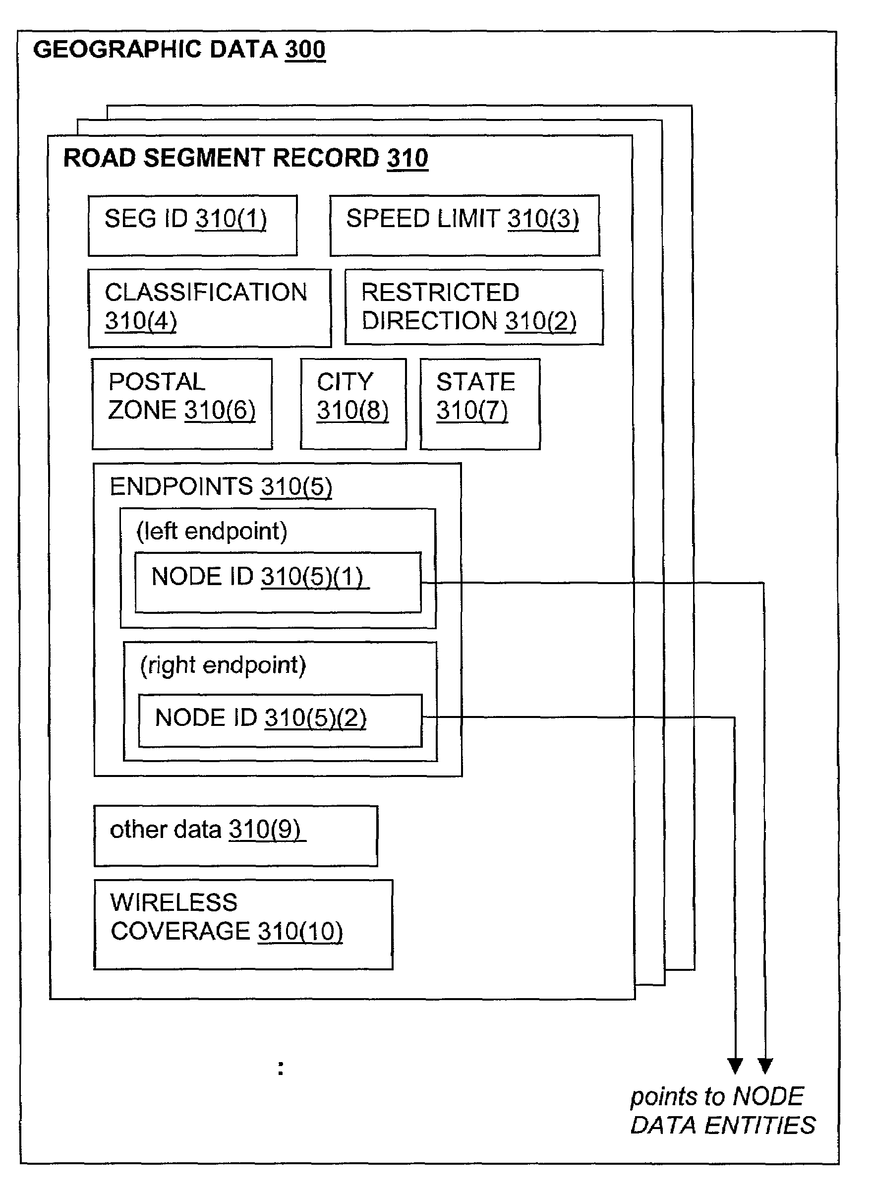
[0039]In alternative embodiments, data that indicate the range of wireless coverage can be associated with data that represent types of geographic features other than road segments. As an example, data that indicate the range of wireless coverage can be associated with data records that represent nodes. Nodes refer to the points at each end of a road segment. According to this embodiment, the geographic database 300 includes data records that represent nodes, i.e., node data records. Some of the components of a node data record 312 are shown in FIG. 4. Each node data record 312 may have associated information (such as “attributes”, “fields”, etc.) that describe features of the represented node. The node record 312 includes a node ID 312(1) by which the data record can be identified in the geographic database 300. The node record 312 also include data 312(2) that indicate the geographic position (e.g., its latitude and longitude coordinates) of the represented node. The node record ...

fourth embodiment

[0045]In a fourth embodiment, data that indicate the range of wireless coverage are associated with data records that represent administrative zones. Administrative zones include countries, states, cities (towns, villages, etc.), counties, townships, provinces, etc. According to this embodiment, the geographic database 300 includes administrative zone records. Some of the components of an administrative zone record 320 are shown in FIG. 6. The administrative zone record 320 includes an ID 320(1) by which the administrative zone record can be identified in the geographic database 300. The administrative zone record 320 also includes data 320(2) that indicate related administrative zones. The administrative zone record 320 may also include data 320(3) that indicate the locations(s) of administrative buildings (e.g., city halls, state capitols, court houses) within the represented administrative zone. The administrative zone data record 320 also includes data 320(4) that indicate the b...


PUM


Abstract

Wireless coverage data are associated with a geographic database that contains data that represent a road network in a geographic region. The wireless coverage data indicate areas within the geographic region in which navigation-related services or data from a navigation services provider are available wirelessly, or conversely, areas within the geographic region in which navigation-related services or data from a navigation services provider are not available wirelessly. An end user obtains the wireless coverage data. The wireless coverage data are used to indicate to the end user areas in which navigation-related services or data from the navigation services provider are available wirelessly or areas in which navigation-related services or data from the navigation services provider are not available wirelessly. The wireless coverage data may also be used to warn the end user when he/she is leaving an area in which navigation-related services or data from the navigation services provider are available wirelessly. Data for uncovered areas can be downloaded to an end user's computing platform while the end user is still within an area in which navigation-related data from the navigation services provider are available wirelessly.

Description

BACKGROUND OF THE INVENTION[0001]The present invention relates to geographic data and systems that use geographic data, and more particularly, the present invention relates to a feature provided by a system, such as a navigation system, whereby a user of the system is provided with information that indicates areas in which navigation-related data are available wirelessly.[0002]There are various computer architectures for navigation systems that provide navigation-related features (including map-related features). In one type of architecture for a navigation system, end users (such as vehicle drivers, passengers, and others) use a wireless communications system to obtain navigation-related services or data from a remotely located navigation services provider. The end users use various computer platforms (e.g., different kinds of electronic devices and / or systems) to connect to the wireless communications system to access the remotely located navigation service provider. Associated wi...

Claims


Application Information

Patent Timeline
Patent Type & Authority Patents(United States)
IPC IPC(8): G01C21/30G09B29/00G01C21/00G01C21/32G06F17/30G08G1/137
CPCG01C21/26G01C21/3461G01C21/32G01C21/3896
Inventor KAPLAN, LAWRENCE M.
Owner HERE GLOBAL BV
Why Eureka
Try Eureka