Eureka AIR delivers breakthrough ideas for toughest innovation challenges, trusted by R&D personnel around the world.

Method of geologic exploration for subsurface deposits

a geologic exploration and subsurface technology, applied in the field of geologic exploration, can solve the problems of high cost of such test holes, high cost of dry test holes, economic burden, etc., and achieve the effect of improving the accuracy of em logging for deep water, shallow water and land applications, and improving the prospectability of the prosp

Inactive Publication Date: 2006-09-12
SEISMIC SCI
View PDF1 Cites 13 Cited by
  • Summary
  • Abstract
  • Description
  • Claims
  • Application Information

AI Technical Summary

Benefits of technology

[0010]An advantage of the present invention is that the data corresponding to subsurface deposits can be automatically uploaded to a remote analyzing station, without the operating personnel on the vehicle having useable access to the data.
[0011]Another advantage is that the geologic exploration method of the present invention can be used with either land or water based exploration systems.
[0012]Yet another advantage is that the position marked data can be transmitted to the vehicle either via a wireless or wired connection.

Problems solved by technology

Nonetheless, the probability of a dry test hole is relatively high.
The high cost of such test holes, particularly in deep sea environments, is an economic burden.
However, the development of an accurate EM logging method for deep water, shallow water and land applications has proven difficult.

Method used


Image

  • Method of geologic exploration for subsurface deposits
  • Method of geologic exploration for subsurface deposits
  • Method of geologic exploration for subsurface deposits

Examples


Embodiment Construction

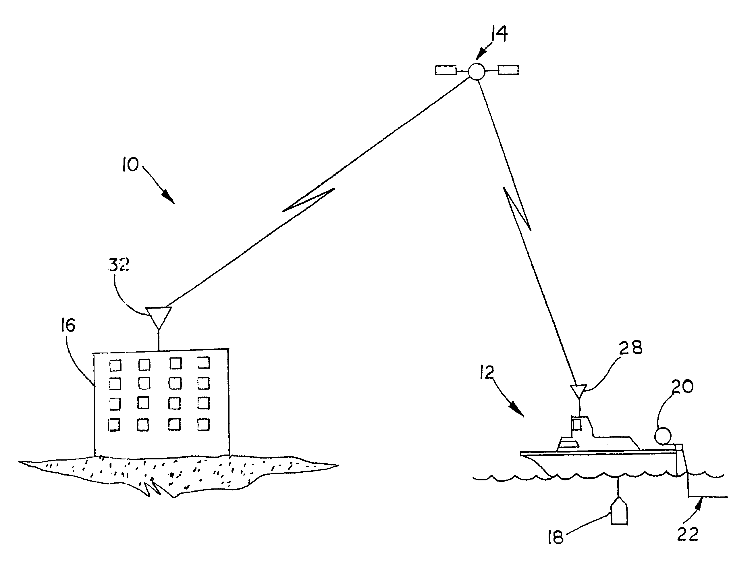
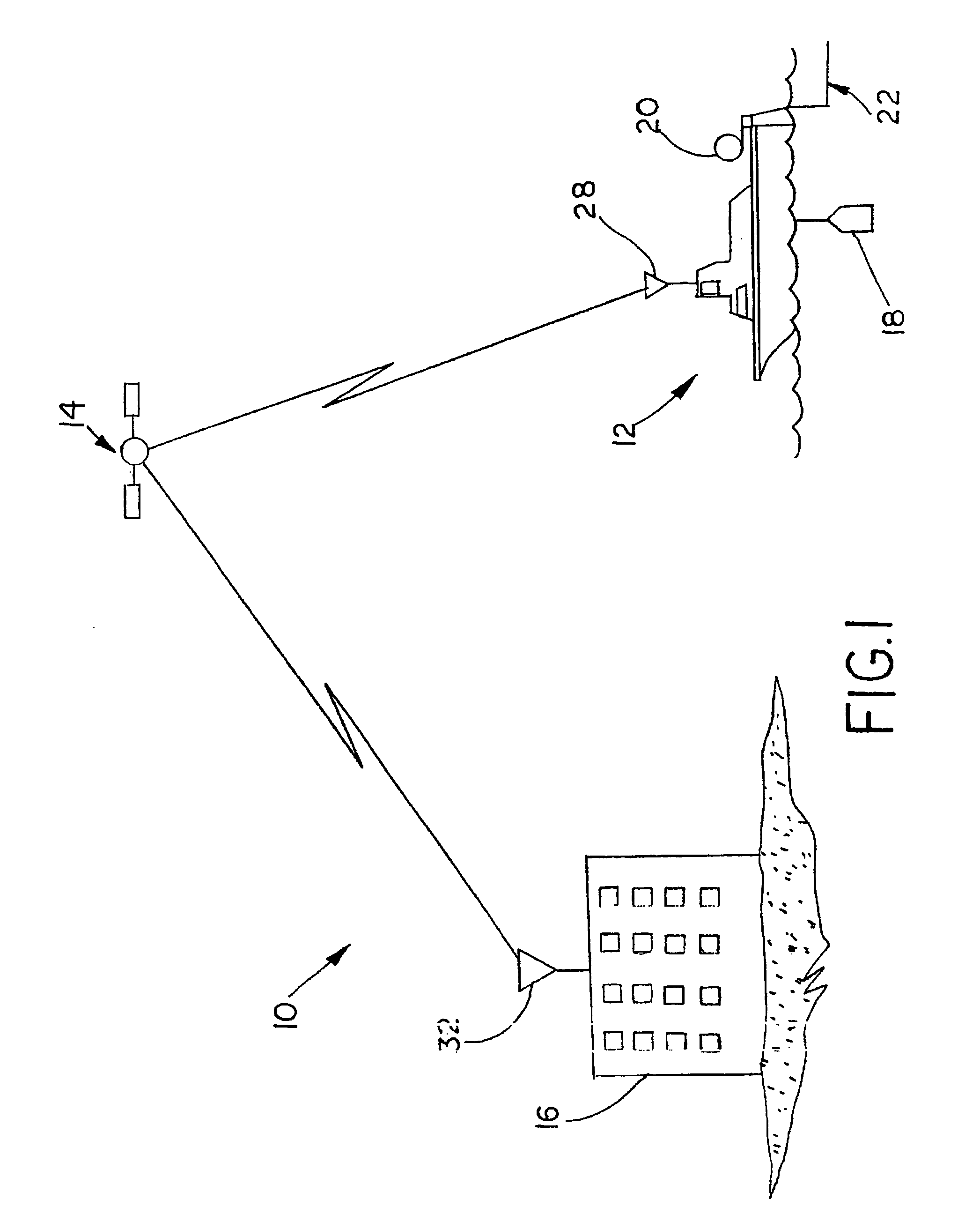
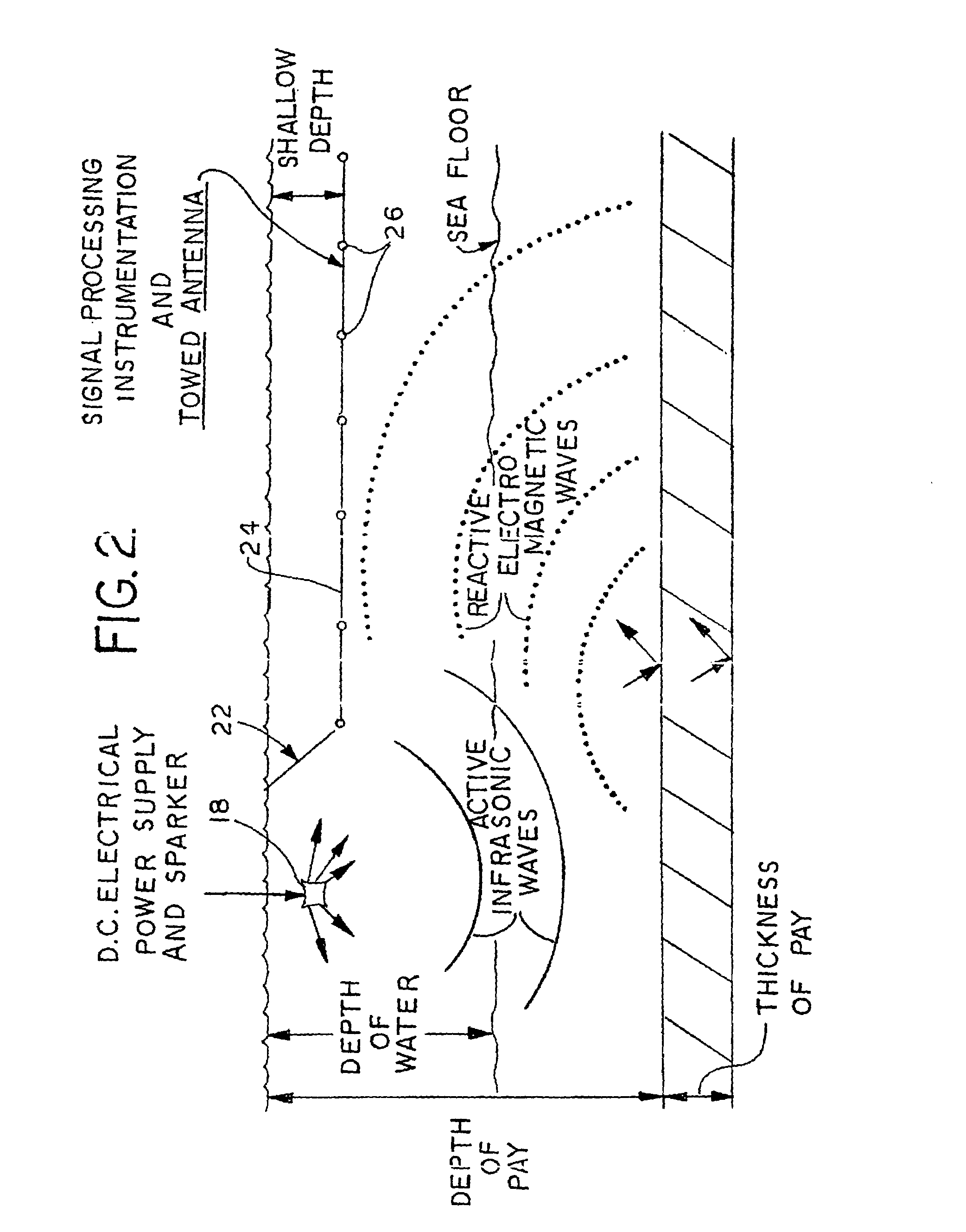
[0019]Referring now to the drawings, and more particularly to FIGS. 1 and 2, there is shown an embodiment of a sea based oil exploration system 10 which may be used to carry out the method of oil exploration of the present invention. Oil exploration system 10 generally includes a vehicle in the form of a boat 12, a satellite 14 and a remote analyzing station 16.

[0020]Boat 12 is deployed at and moves across a surface of the earth, namely, water at a deep sea location. It is also possible that boat 12 may be deployed in a more shallow body of water, such as a shallow ocean location or a freshwater lake.

[0021]Boat 12 carries a deployable sparker 18 which may be selectively actuated to emit low frequency sound waves (less than 50 hertz) which are transmitted through the water and below the sea floor. Sparker 18 is powered by a direct current (DC) electrical power supply and is controllably actuated using an electronic controller (not shown).

[0022]Boat 12 also carries a reel 20, which in...


PUM


Abstract

A method of geologic exploration for subsurface deposits includes the steps of: emitting energy below a surface of the earth; sensing a plurality of reactive electro-magnetic waves resulting from the emitted energy; outputting signals from a plurality of sensors to a vehicle corresponding to the sensed reactive electro-magnetic waves; determining position data for the plurality of sensors; generating position marked data corresponding to the outputted signals and the position data; uploading the position marked data from the vehicle to a satellite; and relaying the position marked data from the satellite to a remote analyzing station.

Description

BACKGROUND OF THE INVENTION[0001]1. Field of the Invention[0002]The present invention relates to geologic exploration, and, more particularly, to methods of gathering and analyzing data for such geologic exploration.[0003]2. Description of the Related Art[0004]Geologic exploration methods vary in type and success rate. For example, in the oil exploration technologies, 3D seismic surveys are commonly used prior to drilling a test well to increase the likelihood of finding an oil deposit below the surface of the earth. Nonetheless, the probability of a dry test hole is relatively high. The high cost of such test holes, particularly in deep sea environments, is an economic burden.[0005]It is also known to use electromagnetic (EM) field methods, referred to as geo-electromagnetic methods, in hydrocarbon exploration such as oil exploration. With active EM logging, energy is transmitted below the surface of the earth and reactive EM waves are measured using appropriate electrical sensing ...

Claims


Application Information

Patent Timeline
IPC IPC(8): G01V3/08
CPCG01V3/12G01V11/00G01V2210/6163
Inventor GRAF, EDWIN X.
Owner SEISMIC SCI
Why Eureka
Eureka Blog
Learn More