Methods for aligning measured data taken from specific rail track sections of a railroad with the correct geographic location of the sections

a technology of rail track and geographic location, applied in the direction of reradiation, instruments, ways, etc., can solve the problems of unreasonably accurate geographic location results, unavailability of correct geographic location references for track measurement data recorded on different test dates, and harm to the environmen

Inactive Publication Date: 2006-10-31
TATA CONSULTANCY SERVICES LTD
View PDF3 Cites 35 Cited by
  • Summary
  • Abstract
  • Description
  • Claims
  • Application Information

AI Technical Summary

Problems solved by technology

Gage widening (increase in separation between left and right rails), rail wear, fatigue-induced cracks, and other conditions have the potential to cause harmful consequences such as train derailments.
However most existing system do not have this advantage, partly because of expense, and therefore must rely on older methods for acquiring geographic location information to aid in locating specific measured characteristics.
Even with the use of GPS, geographic position results may still not be reasonable accurate for exactly pinpointing potential problems.
In the case of the systems that do not have access to GPS, the most critical problem encountered in performance of track degradation analysis is the unavailability of correct geographic location references for track measurement data recorded on different test dates.
Other factors can cause misalignment of geographic location to test-sites, such as odometer malfunctions of a particular test vehicle and inconsistencies of odometer performance from vehicle to vehicle.
If a particular odometer of a test vehicle has a calibration error resulting in inaccurate measurement results, then the amount of error increases with distance traveled.
Error in calibration can result in a standard measurement unit, for example, a foot or a meter, to be recorded longer or shorter than the actual measure.
Moreover, different vehicles used to test a same length of track on different dates may have differing calibration errors, states of wheel wear, or wheel slip conditions resulting in further inconstancies.
The problem can be further affected by human error.
Automatic Location Detectors are available for many railroads and are used to mark and identify geographic location of track measurement data, however these detectors are often not reliably picked up by passing test vehicles and those that are detected still do not provide enough data for correct data alignment.
The method and apparatus of the recursive system comprises an expensive turnkey system, which may in some embodiments also rely on GPS positioning.

Method used


Image

  • Methods for aligning measured data taken from specific rail track sections of a railroad with the correct geographic location of the sections
  • Methods for aligning measured data taken from specific rail track sections of a railroad with the correct geographic location of the sections
  • Methods for aligning measured data taken from specific rail track sections of a railroad with the correct geographic location of the sections

Examples


Embodiment Construction

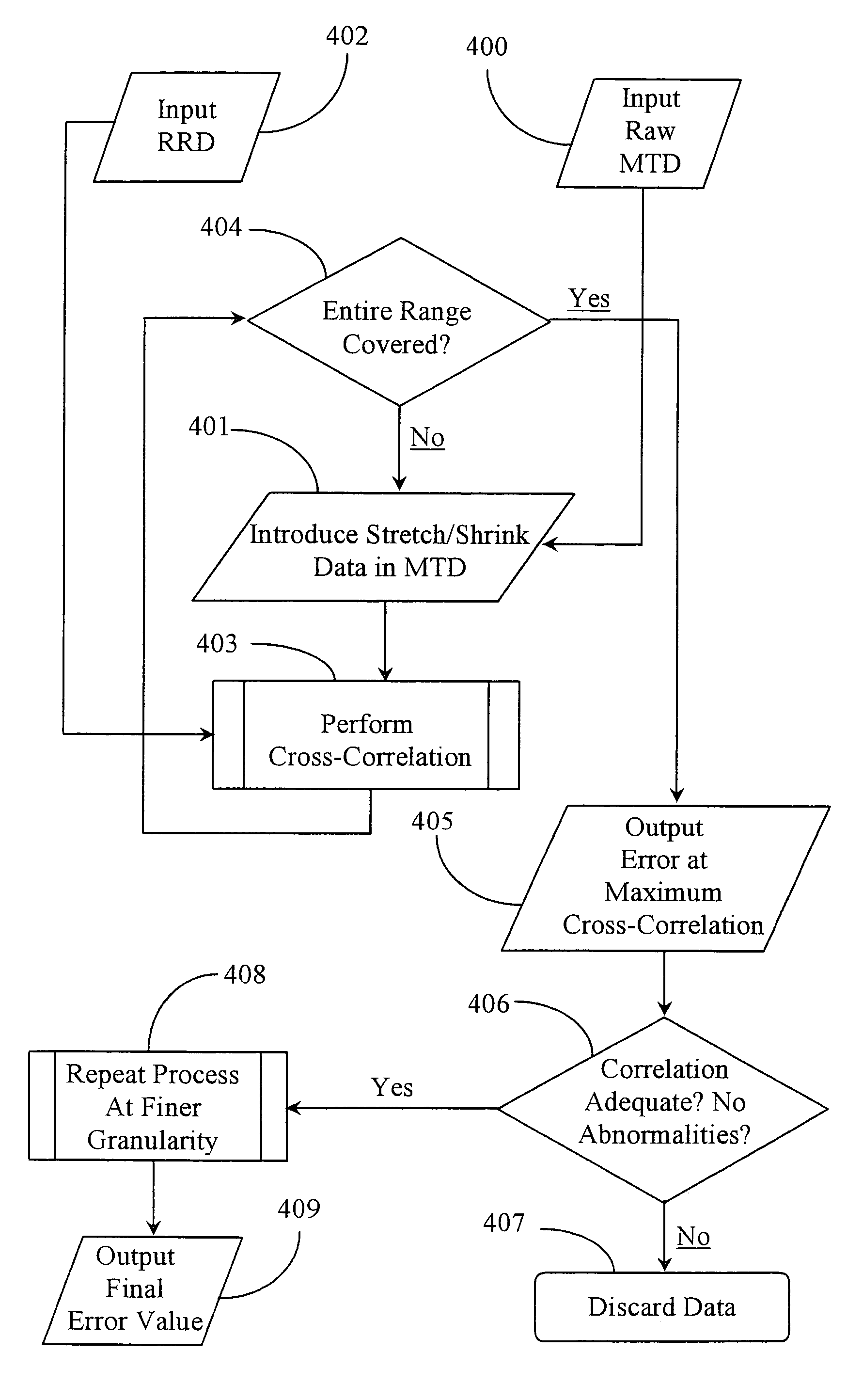
[0032]The inventor provides a unique method and system for utilizing generally available track geography data to locate the correct geographic location of track measurement data taken along a path of railroad track, in absence of previously aligned track measurement data, and / or GPS position data. The methods and apparatus of the present invention are described in enabling detail below.

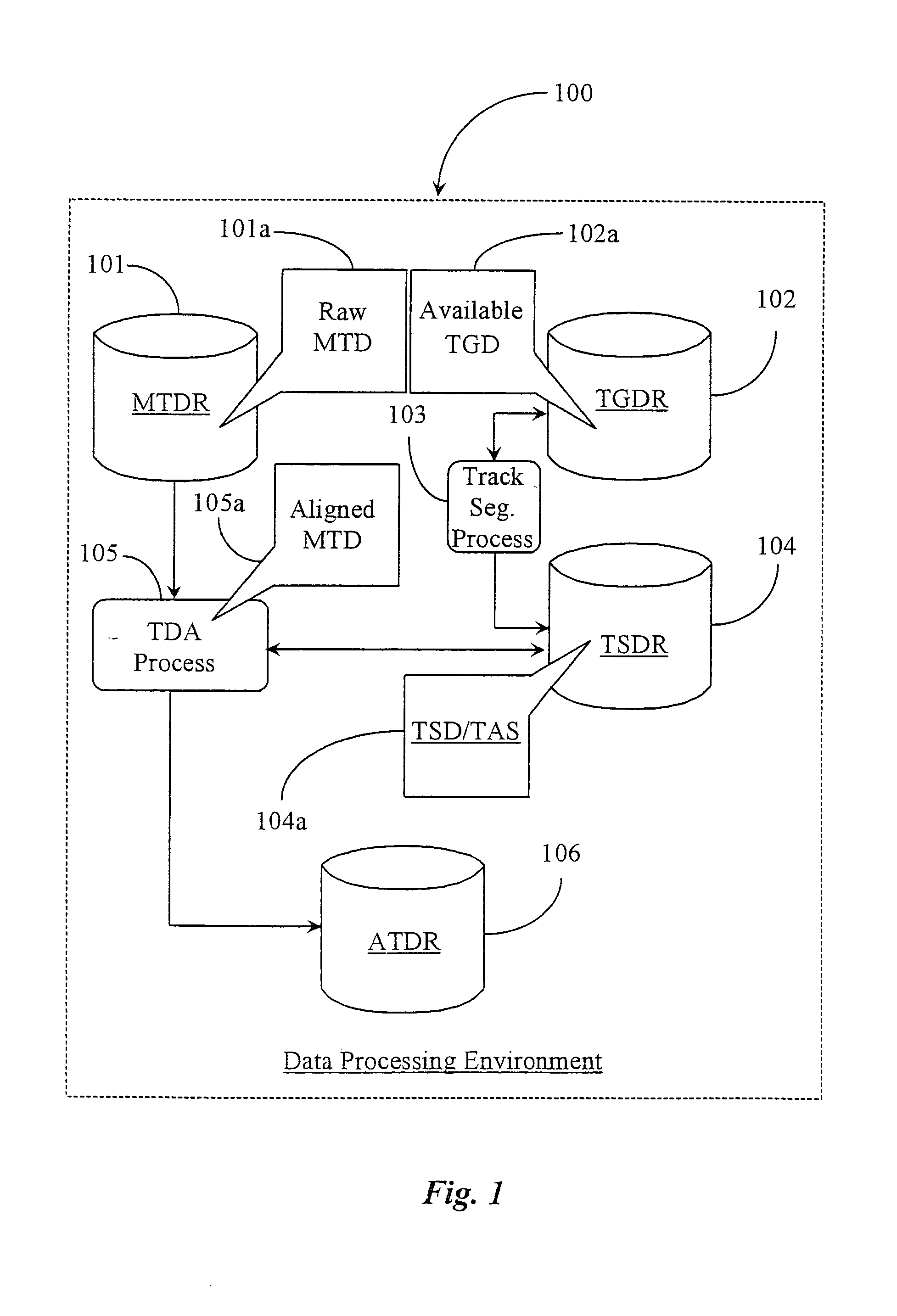
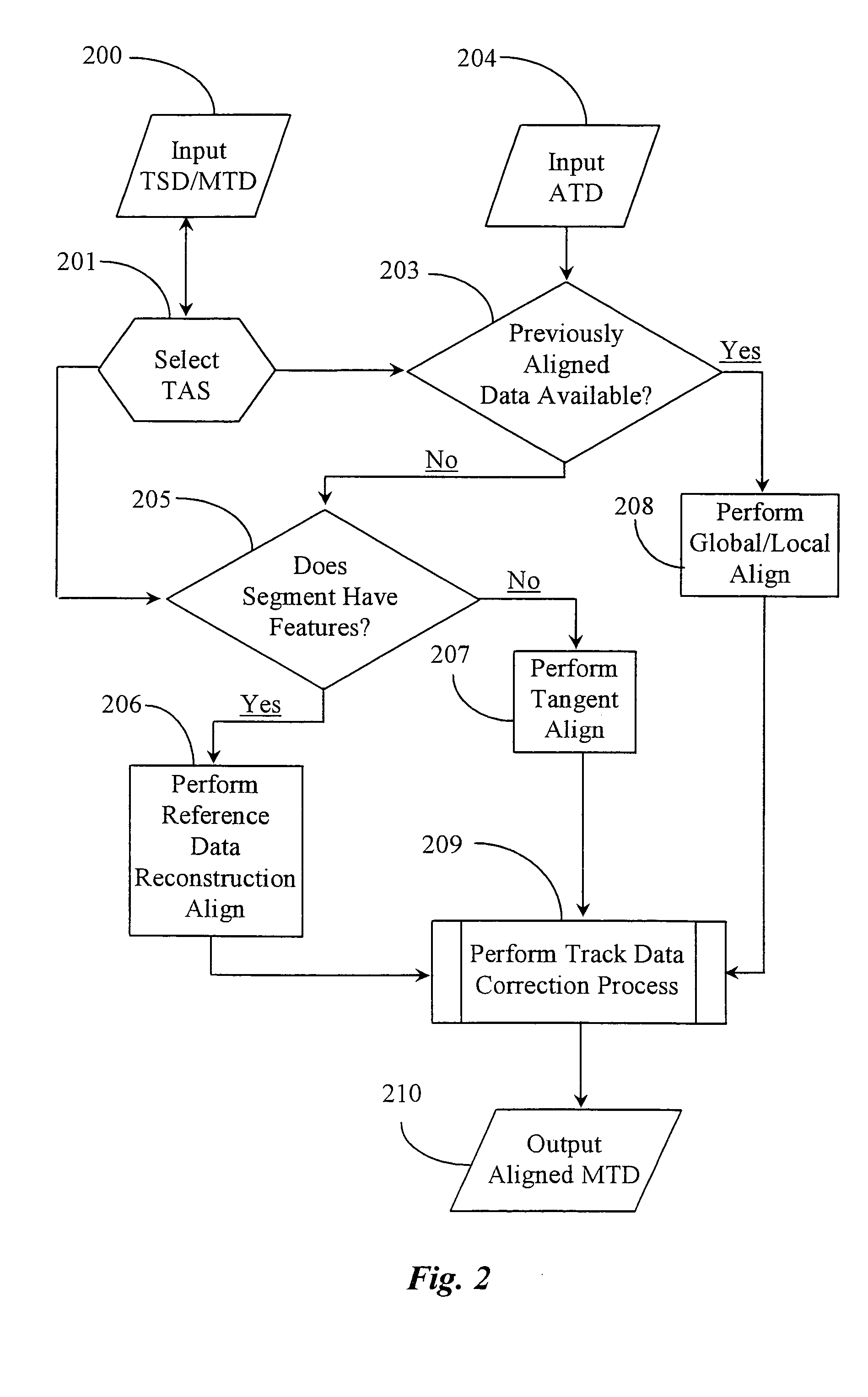
[0033]FIG. 1 is a block diagram illustrating a data processing environment and system 100, including a track-data alignment process 105 conducted in parallel with a track segmentation process 103 according to an embodiment of the present invention. Data processing environment and system 100 is provided for the purpose of aligning correct geographical location with measured track data along a path of railroad track, the track data taken primarily from a measurement test vehicle or a railroad car adapted for the purpose.

[0034]In a preferred embodiment data processing environment 100 is borne on such a v...


PUM


Abstract

A method for aligning measured track data collected from a railroad track to correct geographic location information for geometric parameters in the measured track data includes steps for (a) obtaining track geography data for use as reference data in data alignment; (b) reconstructing the track geography data to simulate in form and in coverage of length the measured track data to be aligned; (c) comparing the reconstructed reference data to the measured track data to identify a relative misalignment value between the data types; and (d) using the value identified through comparison to correct the geographic location information contained in the measured track data.

Description

CROSS-REFERENCE TO RELATED DOCUMENTS[0001]The present application is a continuation application of patent application Ser. No. 10 / 412,364 filed on Apr. 10, 2003 now U.S. Pat. No. 6,804,621, which is incorporated in its entirety by reference.FIELD OF THE INVENTION [0002]The present invention is in the field of railroad track engineering and maintenance, including preventive and proactive care, and pertains more particularly to methods for aligning rail measured track data with correct geographic location of the sections from which the data was measured.BACKGROUND OF THE INVENTION [0003]In the field of railroad engineering and maintenance, proactive maintenance of rails comprising the tracks of a railroad is extremely important for insuring safe operation of trains on the tracks. Gage widening (increase in separation between left and right rails), rail wear, fatigue-induced cracks, and other conditions have the potential to cause harmful consequences such as train derailments. Therefo...

Claims


Application Information

Patent Timeline
Patent Type & Authority Patents(United States)
IPC IPC(8): G06F19/00
CPCB61L25/026E01B37/00
Inventor PEDANEKAR, NIRANJAN RAMESH
Owner TATA CONSULTANCY SERVICES LTD
Why Eureka
Try Eureka