Method for predicting quantitative values of a rock or fluid property in a reservoir using seismic data

a technology of fluid properties and seismic data, applied in the direction of liquid/fluent solid measurements, speed measurement using gyroscopic effects, instruments, etc., can solve the problems of introducing errors into measurements obtained by well logging and core analysis, only able to characterize an extremely small fraction of reservoirs, and changing rock properties

Inactive Publication Date: 2008-05-13
CGG SERVICES SA
View PDF25 Cites 107 Cited by
  • Summary
  • Abstract
  • Description
  • Claims
  • Application Information

AI Technical Summary

Benefits of technology

[0011]In yet another characterization of the present invention, a method is provided for integrating different data types, scales and / or dimensions into multi-dimensional model. The method comprises: providing a multi-dimensional layered model having X, Y and multiple Z axes to store and manipulate data obtained from different domains: assigning first data on one of the Z axis based in a given domain to a volume within the multi-dimensional layered model; assigning second data on another of the Z axis based in one or more other domains to the volume within the multi-dimensional layered model; changing a variable in one of the first data or the second data; and updating the other of the first data or the second data in response to a rule of change so as to provided consistency between the first data and the second data.

Problems solved by technology

Since most logs only measure rock and fluid properties only a few feet from the well bore and the vast majority of the reservoir is not penetrated by wells, the logs are unfortunately only capable of characterizing an extremely small fraction of a reservoir.
Furthermore, the act of drilling stresses the rock surrounding the well bore, thereby changing the rock properties and introducing error into measurements obtained by well logging and core analysis.
However, as acoustic impedance calculated by such inversion software is not constrained by the petrophysical properties of the subterranean zones of interest, the values of acoustic impedance derived from such inversion software often do not accurately reflect the actual rock and fluid properties of the subterranean zones of interest, but rather only relative values.
Accordingly, interpretations of subterranean zones of interest based upon values of acoustic impedance derived by application of such inversion software are often inaccurate and therefore problematic.
However, by first determining acoustic impedance from recorded seismic values, prior to sequentially determining rock properties from acoustic impedance, errors associated with the acoustic impedance determination are compounded by subsequent errors associated with the determining of rock properties from acoustic impedance.
Using the approach outlined above, each volume of seismic data recorded must be sequentially processed using seismic inversion and rock property inversion software resulting in solution ranges for rock properties for different volumes of a given seismic trace which do not overlap and therefore give rise to uncertainty of the accuracy of the results.
However, joint inversion schemes that solve only for elastic properties, such as compressional and shear velocities and densities, do not directly provide information required for important reservoir properties and would require an additional sequential step similar to that described above.
For example, the thinnest layers corresponding to seismic resolution frequently do not describe properties of a scale important for reservoir performance prediction, but are limited to averages of flow-unit scale layers.
Joint inversion schemes that operate in a single vertical axis scale, typically compressional wave 2-way travel time, do not optimally reconcile the location, thickness, velocity relationships of layers at flow unit scale.

Method used


Image

  • Method for predicting quantitative values of a rock or fluid property in a reservoir using seismic data
  • Method for predicting quantitative values of a rock or fluid property in a reservoir using seismic data
  • Method for predicting quantitative values of a rock or fluid property in a reservoir using seismic data

Examples


example

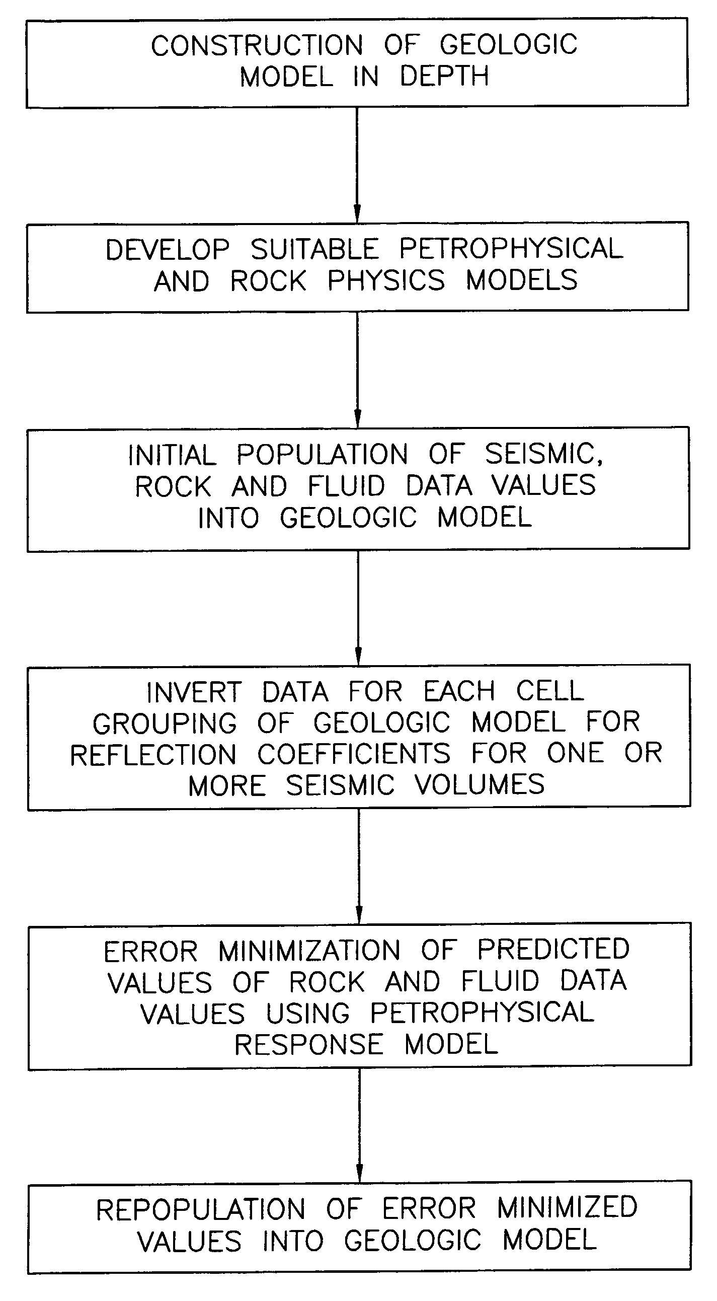
[0063]True seismic traces from near, mid and far partial seismic data stacks are illustrated as 70 in FIGS. 8A, 8B and 8C. In accordance with the process of the present invention, before and after the application of the process of the present invention, a first predicted value of porosity 82 (FIG. 8D) is assigned to a volume of a multi-dimensional, multi-scale gOcad™ model. A first predicted value of seismic response for the model volume is calculated from the porosity value. A synthetic trace 72 is generated and iteratively compared to the corresponding actual trace 70 illustrated in FIGS. 8A, 8B and 8C to determine a difference while consistency is maintained between the types, scales and dimensions of values and data. The first predicted value of porosity 82 is adjusted in response to this difference and the process of calculating a seismic response, generating a trace and comparing the generated trace to the actual trace is iteratively repeated until a match within a predetermin...


PUM


Abstract

A method is provided for predicting a value of a designated rock or fluid property in a subterranean geologic volume. A first predicted value of the designated rock or fluid property is also assigned to a volume of a multi-dimensional, multi-scale model. A first predicted value of seismic response for the model volume is calculated from a response model using the first predicted value of the designated rock or fluid property, wherein the response model is responsive to changes in predicted values of the designated rock or fluid property. A synthetic trace is generated and iteratively compared to the corresponding trace obtained from one or more sets of actual seismic data to determine a difference while consistency is maintained between the types, scales and dimensions of values and data. The first predicted value of the designated rock or fluid property is adjusted in response to the difference to create a second predicted value of the designated rock or fluid property, wherein the second predicted value generally reduces the difference.

Description

TECHNICAL FIELD[0001]The present invention relates generally to a method for predicting quantitative values of a designated rock or fluid property which are error minimized using geologic and petrophysical models and seismic data, and more particularly, to a method for predicting quantitative values of a designated rock or fluid property using a stratigraphic framework in which different data types having differing scales and / or resolutions are managed to ensure internal consistency thereof. The resulting multi-dimensional, multi-scale model facilitates recovery of a subterranean resource, such as oil, gas, water and / or mineral(s), or recovery and / or containment of pollution.BACKGROUND OF THE INVENTION[0002]In the exploration for and / or the exploitation of a resource, such as hydrocarbons, from subterranean environs, there is an ongoing need to accurately characterize subterranean reservoirs of interest. Knowing the areal extent, hydrocarbon content, and fluid permeability of a hydr...

Claims


Application Information

Patent Timeline
Patent Type & Authority Patents(United States)
IPC IPC(8): G01V1/00G01V1/30
CPCG01V1/306G01V1/282
Inventor HAMMAN, JEFFRY G.CALDWELL, DONALD H.ALLO, FABIENBORNARD, RAPHAELCOLEOU, THIERRYCROZAT, THIERRYDESCHIZEAUX, BERNARDLAFET, YVESLANFRANCHI, PIERREMOLLE, AMELIE RODRIGUE
Owner CGG SERVICES SA
Why Eureka
Try Eureka