Car navigation system

a technology for navigation systems and cars, applied in traffic control systems, navigation instruments, instruments, etc., can solve the problems of difficult search for restaurants or parking lots, high display, and user difficulty in finding the desired drop-in place in the many-structure area, so as to get the route to the target position easily and clearly

Inactive Publication Date: 2008-06-24
HITACHI LTD
View PDF21 Cites 48 Cited by
  • Summary
  • Abstract
  • Description
  • Claims
  • Application Information

AI Technical Summary

Benefits of technology

[0012]It is therefore an object of the present invention to provide a car navigation system which can solve the above problems in the prior art, guide a vehicle to a suitable route, guide the vehicle even a second target desired by a driver on the way to an initial target position, and allow the driver get the route to the target position easily and clearly.

Problems solved by technology

However, when the car runs in an area having many structures or in an area having many tangled roads crossing each other, many structures are displayed, which results in that the user cannot easily find a desired drop-in place in the many-structure area.
In particular, in a city or town having many high-rise buildings, even when the driver wants to drop in at a desired restaurant or parking lot, such an area usually has many low buildings, so such a low building often tends to be hidden by another high building and cannot be displayed.
As a result, roads are displayed as intersected and tangled and many facilities are also displayed together with their titles, thus resulting in highly complicated display.
For this reason, it is highly difficult to search for a restaurant or parking lot which is usually not a target position but at which the driver just wants to drop in.
Further, when the driver wants to drop in at such a place after the vehicle runs by a certain distance, and even when the bird's eye view is displayed, it is impossible to display and find the place which has a low priority and is located away by a certain distance or more.
As mentioned above, prior art car navigation systems including the above two car navigation systems for guiding a vehicle up to a passenger's or driver's desired position (target position) along a running route have had a problem which follows.
That is, when the driver wants to drop in at a restaurant or parking lot as necessary on the way to the target position, the driver must troublesomely search the displayed three-dimensional map or bird's eye view map for the desired drop-in place.
However, when the car navigation system receives such traffic information, the passenger or driver must troublesomely determine whether to run the vehicle along the guided route or to find a detour by himself.
Thus when the driver have a poor knowledge of a road network in the vicinity, he has to inevitably run the vehicle along the congested route.
The aforementioned conventional car navigation system has another problem.
That is, when the driver run the vehicle in an area such as a city or town having tangled roads crossing each other, a road map is displayed showing the tangled roads as they are, and the driver cannot sometimes find a running route easily.
In particular, in the case of an intersection having a right or left turn, the driver has a hard time to find the intersection because the displayed road map has too much information.
In this way, the conventional car navigation systems including the above two car navigation systems also have a problem.
That is, when a special situation takes place during the running of the vehicle along the route, no suitable, easy-to-understand guidance is given to the driver.

Method used


Image

  • Car navigation system
  • Car navigation system
  • Car navigation system

Examples


Embodiment Construction

[0060]An embodiment of the present invention will be explained with reference to the accompanying drawings.

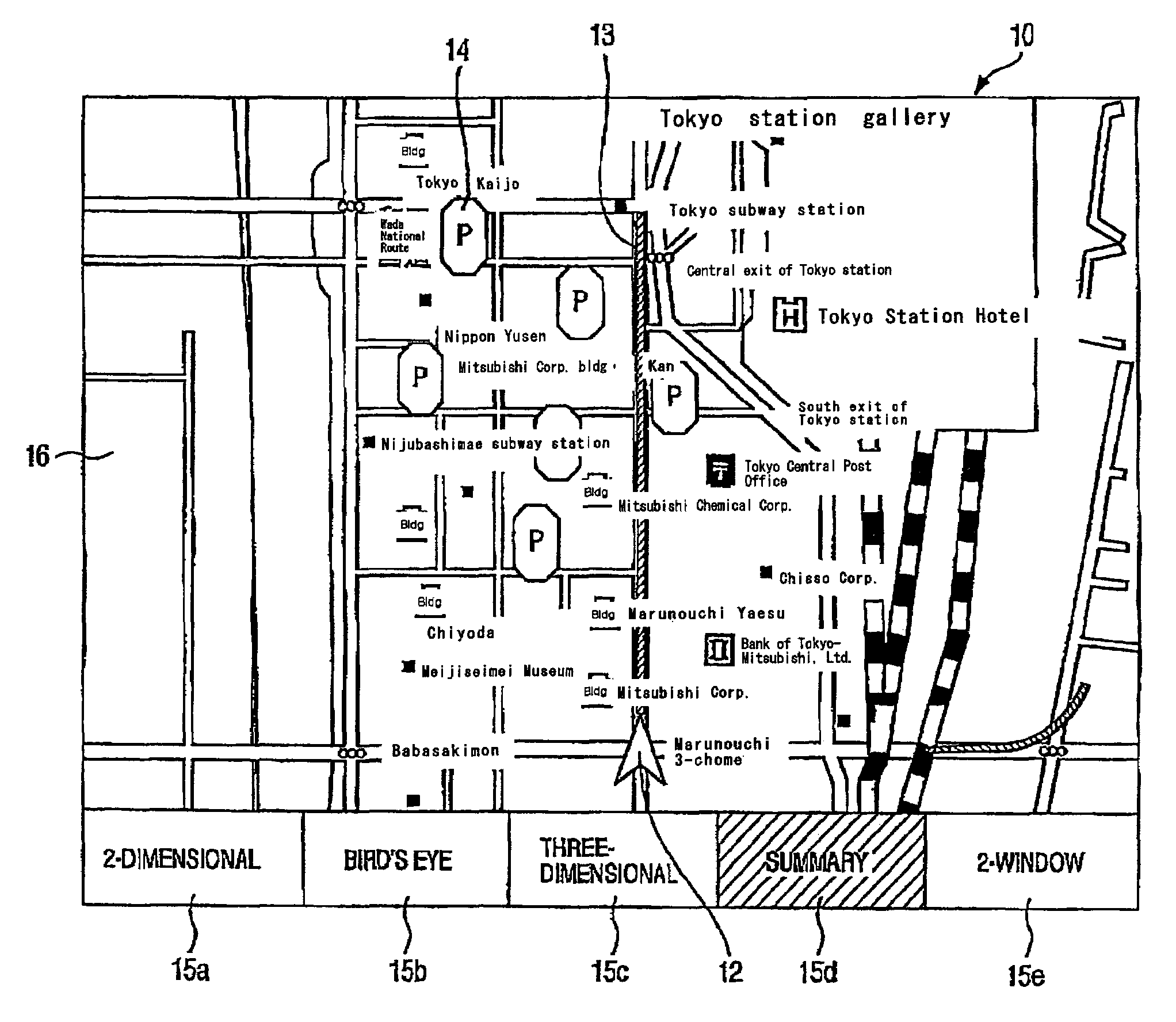
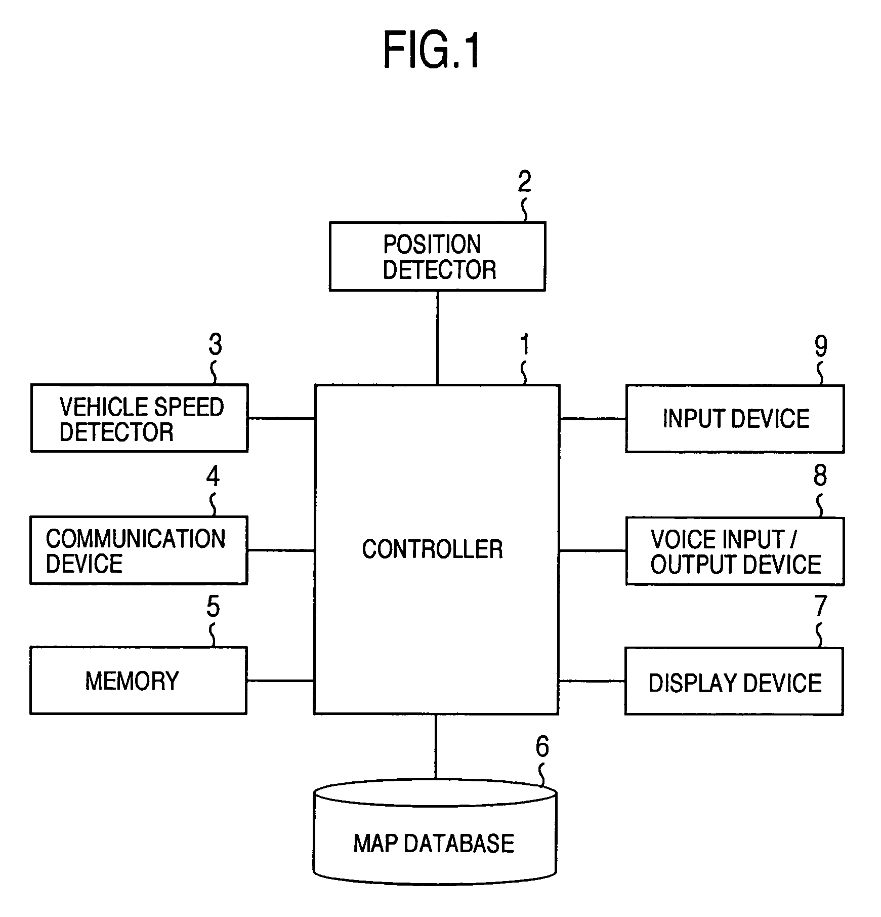
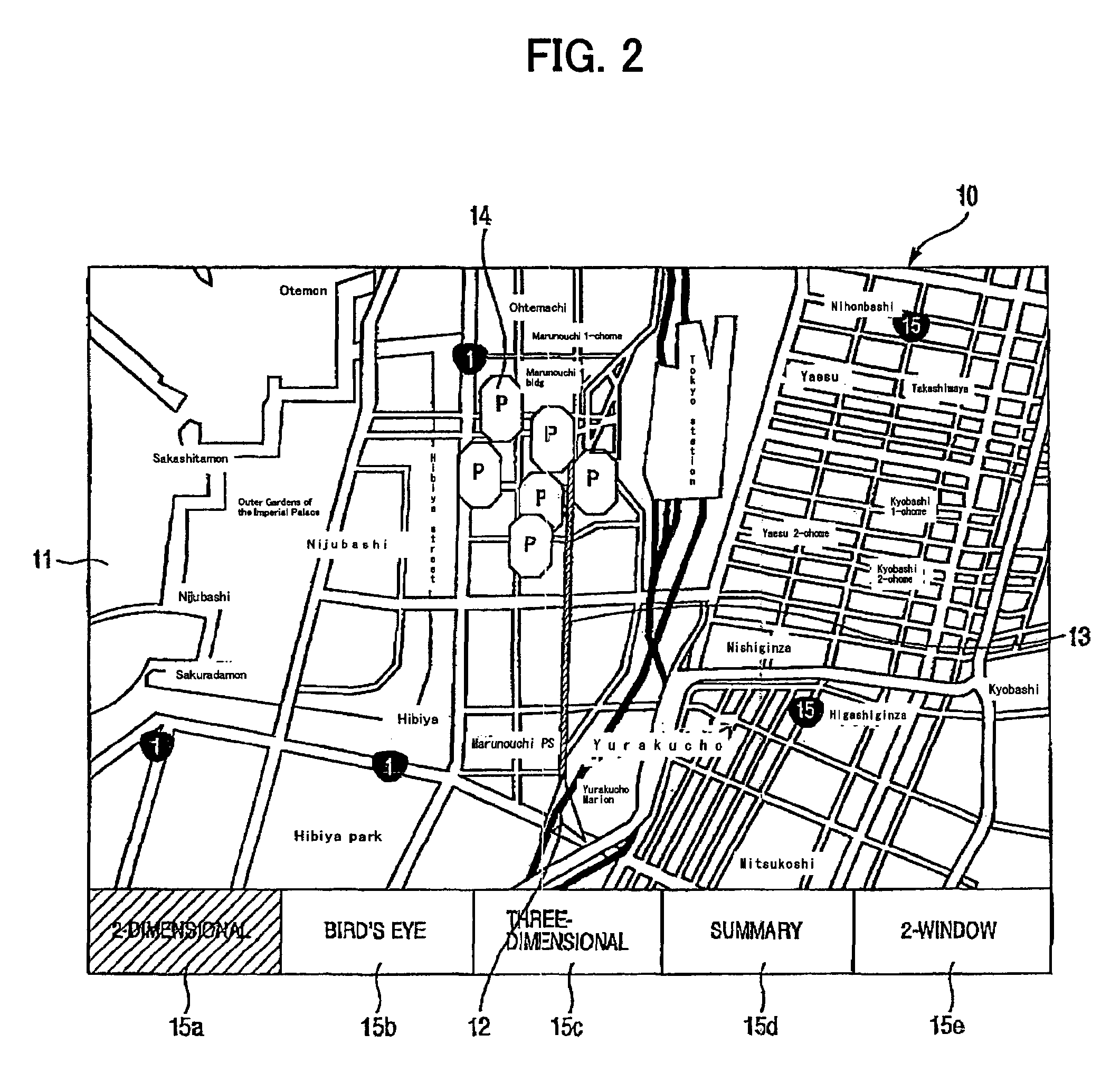
[0061]FIG. 1 shows a block diagram of an arrangement of a car navigation system in accordance with an embodiment of the present invention, wherein reference numeral 1 denotes a controller, numeral 2 denotes a position detector, 3 denotes a vehicle speed detector, 4 denotes a communication device, 5 denotes a memory, 6 denotes a map database, 7 denotes a display device, 8 denotes a voice input / output device, and 9 denotes an input device.

[0062]In the drawing, the map database 6 has road map data for various areas stored therein, and such road map data is once downloaded in a memory 5 from an external device through the communication device 4. The road map data stored in the memory 5 is stored in the map database 6 under control of the controller 1. In the illustrated example, it is unnecessary to previously store road map data covering all national areas from the beginning. That...


PUM


Abstract

A car navigation system by which a user can easily grasp a drop-in target in the course of a route. In a summary road map displayed in a two- or one-window display representation, contents of a two-dimensional road map is properly selected and simplified, roads are made linear, roads connected to an intersection are made orthogonal so that the user can easily see it, the position of a vehicle is expressed by a mark, and even the running route is expressed with a predetermined color or the like. Accordingly, the system offers the user such a display form as able to easily refer to. When the user specifies a target at which the user wants to drop in, the drop-in target is displayed at a corresponding position on the summary road map in the form of a land mark.

Description

BACKGROUND OF THE INVENTION[0001]The present invention relates to a car navigation system which measures a current position of a vehicle, displays a map and the current position on the map on a display screen, and guides a passenger or driver of the vehicle to a target position.[0002]As a prior art system for reliably guiding a vehicle to a target position along a route, a car navigation system is known. In an example of the prior art, for the purpose of displaying the vicinity of the current position of the vehicle (equipped with the system), the vicinity of the target position, or the vicinity of a guiding intersection in an easy-to-understand manner, there is proposed a system which displays a map in a three-dimensional manner (refer to, e.g., JP-A-2001-273526).[0003]In a car navigation system disclosed in the above JP-A-2001-273526, structures on a road map in a bird's eye view are displayed three-dimensionally. As an example, buildings located within a predetermined distance fr...

Claims


Application Information

Patent Timeline
Patent Type & Authority Patents(United States)
IPC IPC(8): G06T15/20G09B29/00G01C21/00G01C21/30G01C21/36G08G1/0969G09B29/10
CPCG01C21/3626G01C21/3676G09B29/106
Inventor MARUYAMA, KISHIKOTANIZAKI, MASAAKISHIMADA, SHIGERU
Owner HITACHI LTD
Why Eureka
Try Eureka