Proximity search methods using tiles to represent geographical zones

a geographical zone and search method technology, applied in the field ofproximity search techniques, can solve the problems of insufficient accuracy, inability to perform accurate proximity searches, and inability to reduce the computational cost of distance calculations based on zip codes and postal codes, so as to achieve the effect of increasing the speed of execution, reducing the total number of distance calculations, and increasing the accuracy of proximity searches

Active Publication Date: 2009-10-20
META PLATFORMS INC
View PDF49 Cites 101 Cited by
  • Summary
  • Abstract
  • Description
  • Claims
  • Application Information

AI Technical Summary

Benefits of technology

[0011]Proximity searches carried out in the above manner no longer require individual distance calculations between the reference location and each database record being searched. As a result, the total number of distance calculations is reduced with the invention and the speed of the executed searches is increased. The invention also provides flexibility in designing proximity searches, e.g., the accuracy of proximity searches can be increased by decreasing the tile size and the speed of the proximity searches can be increased by increasing the tile size.

Problems solved by technology

When the number of database records is large, the proximity search method carried out in the above manner becomes computationally very expensive because of the large number of distance calculations that are required.
Distance calculations that are based on zip codes and postal codes have been used to reduce the computational cost, but are not very accurate, and only work for locations in countries having postal codes that are mapped to latitude-longitude values.
For proximity searching, they are either too inaccurate (e.g., when the region size is large) or computationally too expensive (e.g., when the region size is sufficiently small).

Method used


Image

  • Proximity search methods using tiles to represent geographical zones
  • Proximity search methods using tiles to represent geographical zones
  • Proximity search methods using tiles to represent geographical zones

Examples


Embodiment Construction

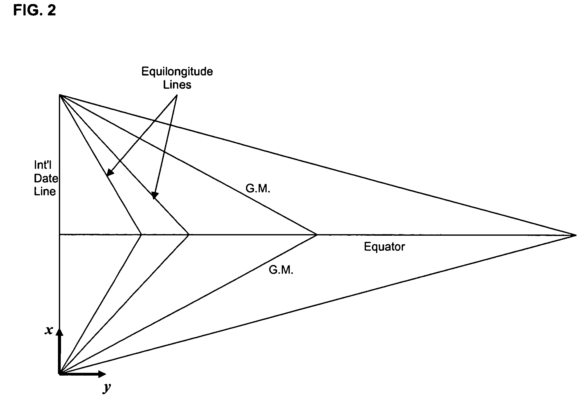
[0022]Each geographic location in FIG. 1, which can be represented as latitude and longitude, may be mapped onto a point in FIG. 2. In fact, the map of FIG. 1 is divided into a plurality predefined geographical regions or areas, referred to as tiles, and all points contained in one tile map onto a single point in FIG. 2. A tile can have any configuration, but in the embodiment of the invention described herein, each such tile covers roughly the same area in FIG. 1 and all four sides of each such tile have the same fixed length. The formulas used for mapping a location in FIG. 1 that is defined by latitude and longitude onto a point in FIG. 2 are as follows:

LatQ=Int((latitude+90)*k / r+1); and

LongQ=Int((longitude+180)*k Cos (latitude / r+1),

where latitude and longitude values are expressed in degrees; k is a factor for converting a 1-degree arc measured with respect to earth's center into miles (k=2π*(earth's radius) / 360°=69.0933 miles / degree); r is the length of each side of a tile (in ...


PUM


Abstract

A proximity search engine for carrying out a proximity search with respect to a reference location uses as a reference frame the earth divided into tiles, which are predefined geographic regions of substantially equal areas. Records that are searched based on proximity to a reference location include location pointers, each of which identifies a particular tile that encompasses the physical location indicated by the corresponding record. When the proximity search is carried out, the tiles that are within a specified distance from the reference location are obtained and records having location pointers corresponding to such tiles are selected for inclusion in the search results.

Description

BACKGROUND OF THE INVENTION[0001]1. Field of the Invention[0002]The present invention generally relates to proximity search techniques, and more specifically, to a method and a system for performing searches based on proximity to a reference location.[0003]2. Description of the Related Art[0004]A geographic location may be represented as latitude and longitude. FIG. 1 illustrates a map of the world with latitude lines shown every 30 degrees and longitude lines shown every 30 degrees. The distance between any two points on the map shown in FIG. 1 may be calculated based on their latitude and longitude positions, and the known radius of the earth (6371.01 km or 3958.76 miles).[0005]There are many ways of obtaining the latitude and longitude for a particular geographic location. Latitude and longitude positions for locations specified using zip codes, postal codes and cities may be obtained from third party databases using a simple table look-up. Also, a handheld electronic device, suc...

Claims


Application Information

Patent Timeline
Patent Type & Authority Patents(United States)
IPC IPC(8): G06G7/48
CPCG06F17/30241G06F16/29
Inventor GALBREATH, NICHOLASSOUNG, YUH-WEN
Owner META PLATFORMS INC
Why Eureka
Try Eureka