History or image based methods for altitude determination in a radar altimeter

a radar altimeter and image based technology, applied in the field of history or image based methods for altitude determination in a radar altimeter, can solve the problems of data points pulling or skewing the computed value, and causing the final computed value to be skewened

Active Publication Date: 2010-11-02
HONEYWELL INT INC
View PDF21 Cites 22 Cited by
  • Summary
  • Abstract
  • Description
  • Claims
  • Application Information

AI Technical Summary

Problems solved by technology

This causes the altimeter to display altitudes that are too low and sometimes dangerously too high.
Unfortunately this method permits one or more erroneous or large change measurements to skew the final computed value.
This tends to cause any “outlying data points” to pull or skew the computed result.
These limited altitude extents can mislead the tracking algorithms or incur delays in acquiring or following rapidly changing topology.
The tracking loop may be adversely impacted if the rate of change of altitude is greater than the tracking window altitude extent.

Method used


Image

  • History or image based methods for altitude determination in a radar altimeter
  • History or image based methods for altitude determination in a radar altimeter
  • History or image based methods for altitude determination in a radar altimeter

Examples


Embodiment Construction

[0018]In the following detailed description, reference is made to the accompanying drawings, which form a part hereof, and in which is shown by way of illustration specific embodiments in which the inventions may be practiced. These embodiments are described in sufficient detail to enable those skilled in the art to practice the invention, and it is to be understood that other embodiments may be utilized and that logical, mechanical and electrical changes may be made without departing from the spirit and scope of the present invention. The following detailed description is, therefore, not to be taken in a limiting sense, and the scope of the present invention is defined only by the claims and equivalents thereof.

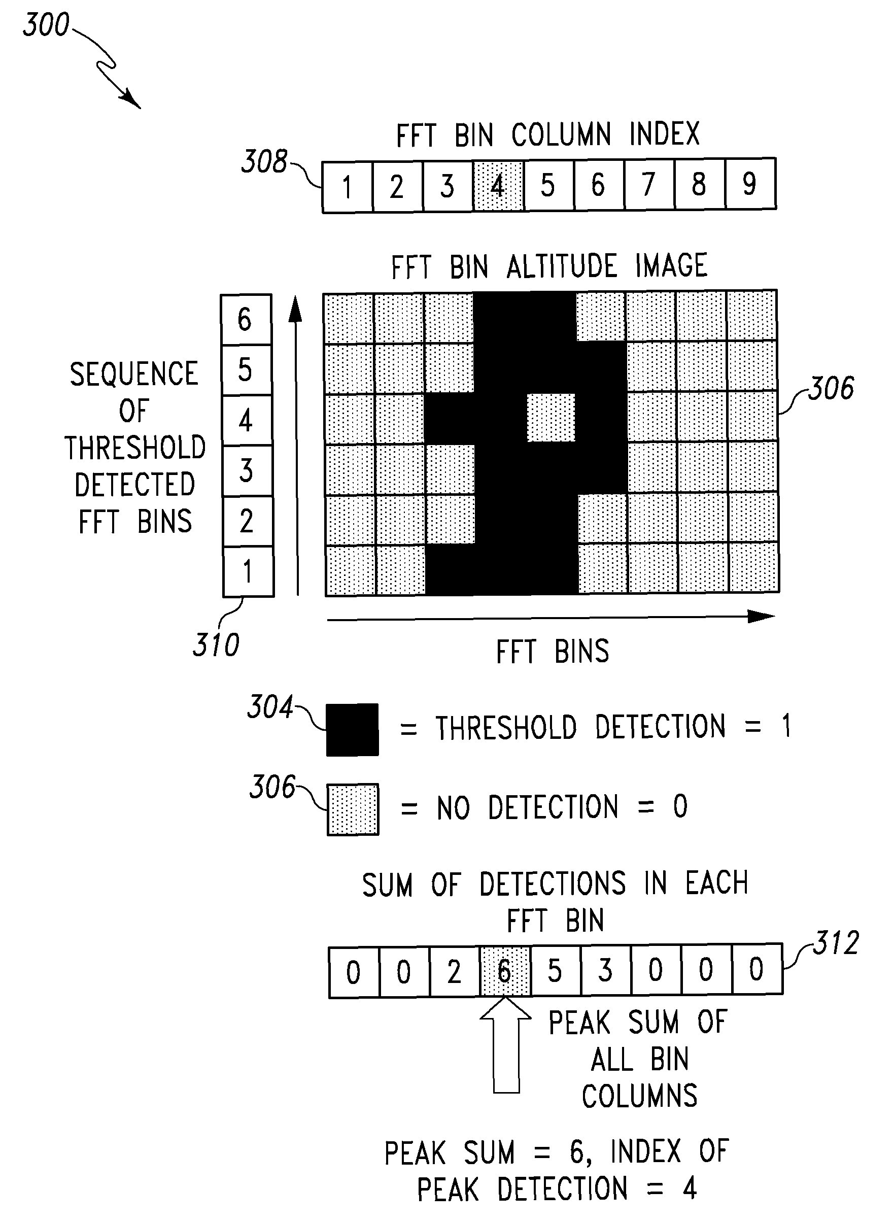
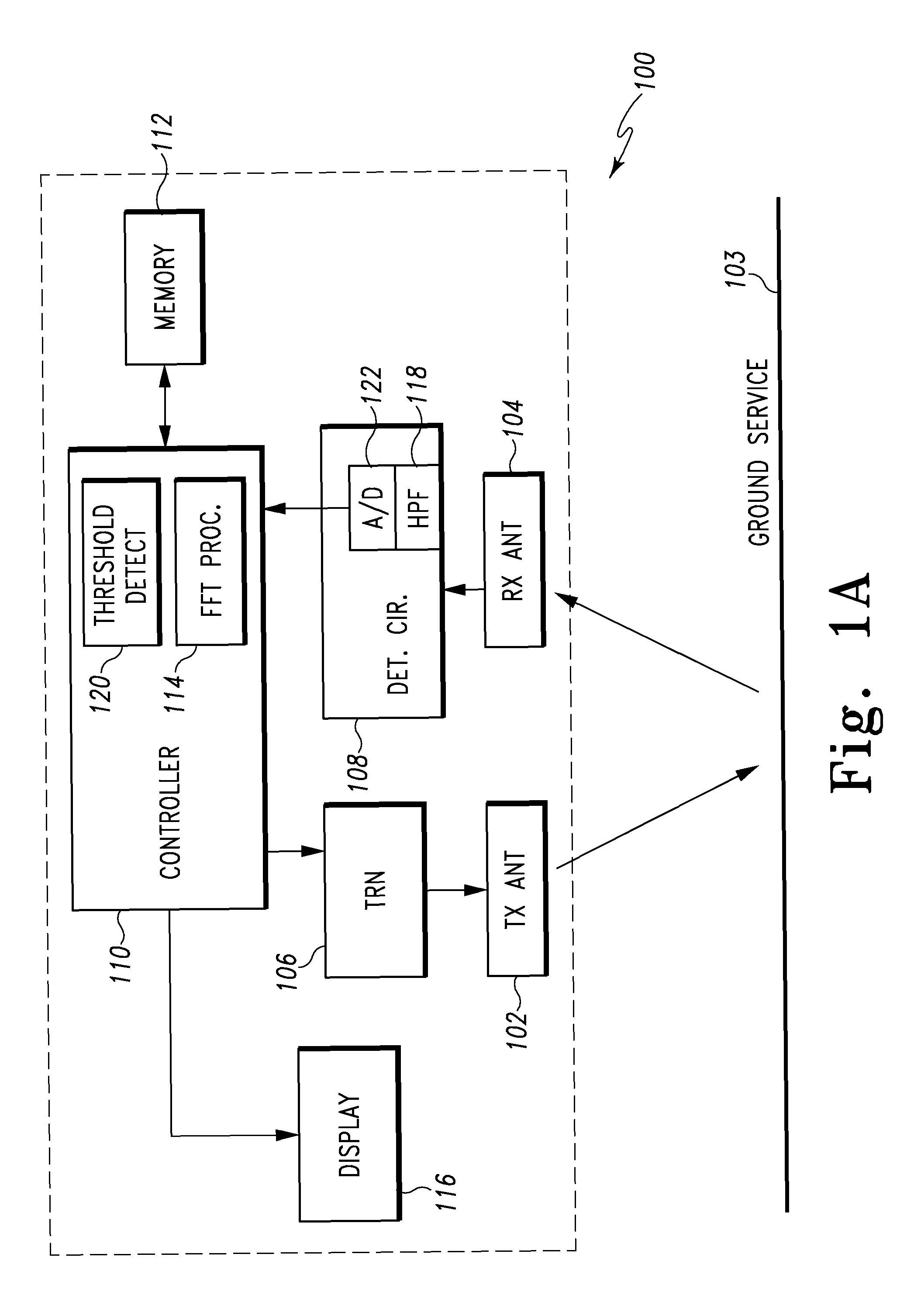
[0019]Embodiments of the present invention use history or image based processing of ground returns collected by the radar altimeter to reduces the effects of a) step change in ground altitude, b) brightness variation in ground reflections, c) rain echo effects, d) aircraft b...


PUM


Abstract

Methods and apparatus for determining an altitude with an altimeter is provided. One method includes transmitting a signal having a fixed modulation period towards a ground target and then detecting reflected signals off the ground target. The method then implements a single Fast Fourier Transform (FFT) on the detected signals for each modulation period that computes all possible altitudes in real time. A short history of the real time altitude calculations is collected and then the altitude based on the short history of the real time altitude calculations is determined.

Description

CROSS REFERENCE TO RELATED APPLICATIONS[0001]This application claims the benefit of U.S. Provisional Application No. 60 / 911,701, filed on Apr. 13, 2007, which is incorporated herein by reference in its entirety.BACKGROUND[0002]Aircrafts employ altimeter systems to determine the altitude of the aircraft above terrain. Typical frequency modulation-continuous wave (FM / CW) radar altimeter systems use a single servo loop that attempts to detect a leading edge of a single first return and adjust the parameters of the radar altimeter modulation so as to maintain a constant input frequency to signal processing equipment of the altimeter. In traditional systems only one potential altitude detection is made, ignoring the possibility that the earliest reply is not the ground but some other intervening object such as a tree top, building top, another plane, large machinery top such as construction cranes, rain, etc. This causes the altimeter to display altitudes that are too low and sometimes d...

Claims


Application Information

Patent Timeline
Patent Type & Authority Patents(United States)
IPC IPC(8): G01S13/08G01S13/00
CPCG01S7/352G01S13/34G01S13/882G01S2007/356G01S7/356
Inventor VACANTI, DAVID C.
Owner HONEYWELL INT INC
Why Eureka
Try Eureka