Method and system for using geographic data in computer game development

a computer game and geographic data technology, applied in the field of system and method that facilitate the development of computer games, can solve the problems of time-consuming and expensive collection of such detailed geographic data about real world roads, places, etc., and place a burden on computer game developers,

Active Publication Date: 2011-06-28
HERE GLOBAL BV
View PDF55 Cites 136 Cited by
  • Summary
  • Abstract
  • Description
  • Claims
  • Application Information

AI Technical Summary

Benefits of technology

[0008]To address these and other objectives, the present invention includes a system and method for facilitating development of computer games that depict or represent actual, real world (or imaginary) geographic areas as part of the play scenarios of the games. A source database contains data that represent geographic features in a region including roads in the region. The data in the source database includes attributes suitable for use for providing navigation-related functions. In addition to providing data from the source database for navigation-related functions, data from the source database are also provided for computer game development. An application programming interface, as well as other tools for handling geographic data, is provided for accessing and processing of the geographic data.

Problems solved by technology

This has placed a burden on computer game developers to obtain the data needed to portray geographic places with realistic detail and accuracy.
The collection of such detailed geographic data about real world roads, places, etc., is time-consuming and expensive.
Even if a computer game developer collects all the data needed to depict a particular real world locale (such as a city) with the richness and detail expected by game players, the game play scenario is limited to only that particular locale.
This may limit the appeal of the computer game.
However, if a computer game developer wants to provide a game with different real world locales, the developer is required to collect geographic data for each different locale, thus incurring further considerable expense.

Method used


Image

  • Method and system for using geographic data in computer game development
  • Method and system for using geographic data in computer game development
  • Method and system for using geographic data in computer game development

Examples


first embodiment

III. First Embodiment

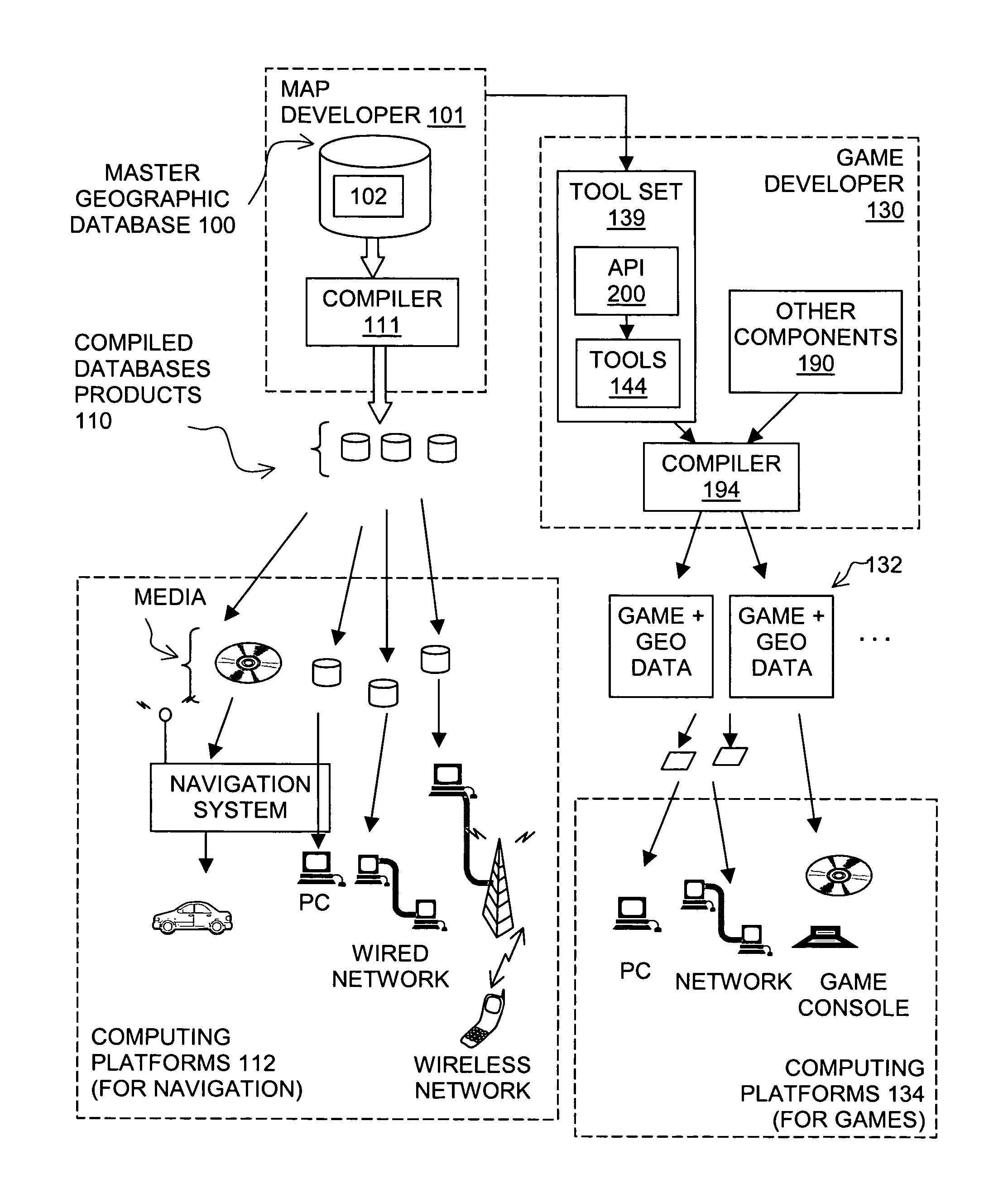
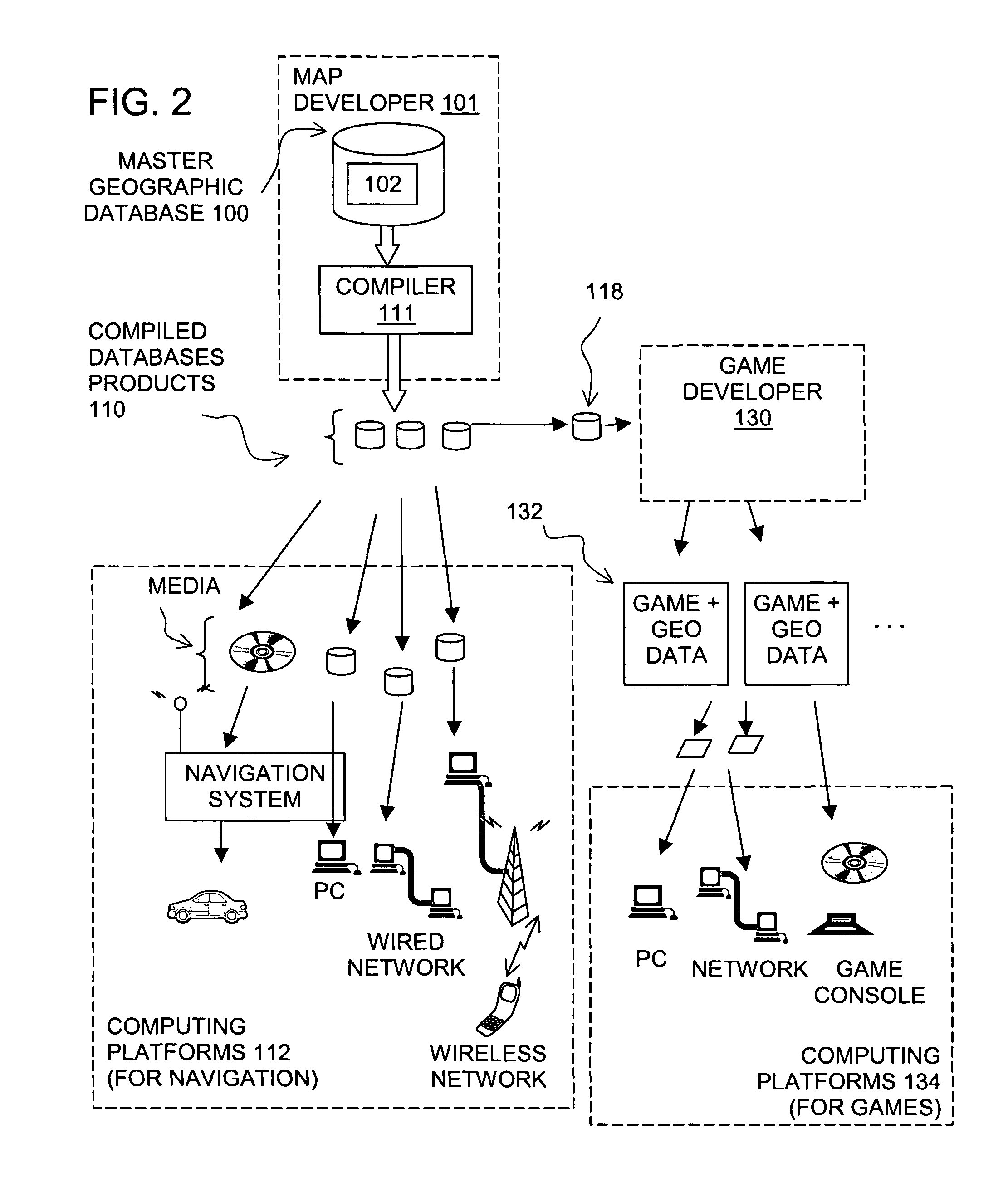
[0024]FIG. 2 shows an overview of a first embodiment of a system and method for facilitating the development of computer games that include representations of actual geographic features, such as roads, in a geographic area. In FIG. 2, the master version of the geographic database 100 is used to make compiled database products 110. The compiled database products 110 are made using a compiler 111. The compiler 111 is a software program run on an appropriate computer platform.

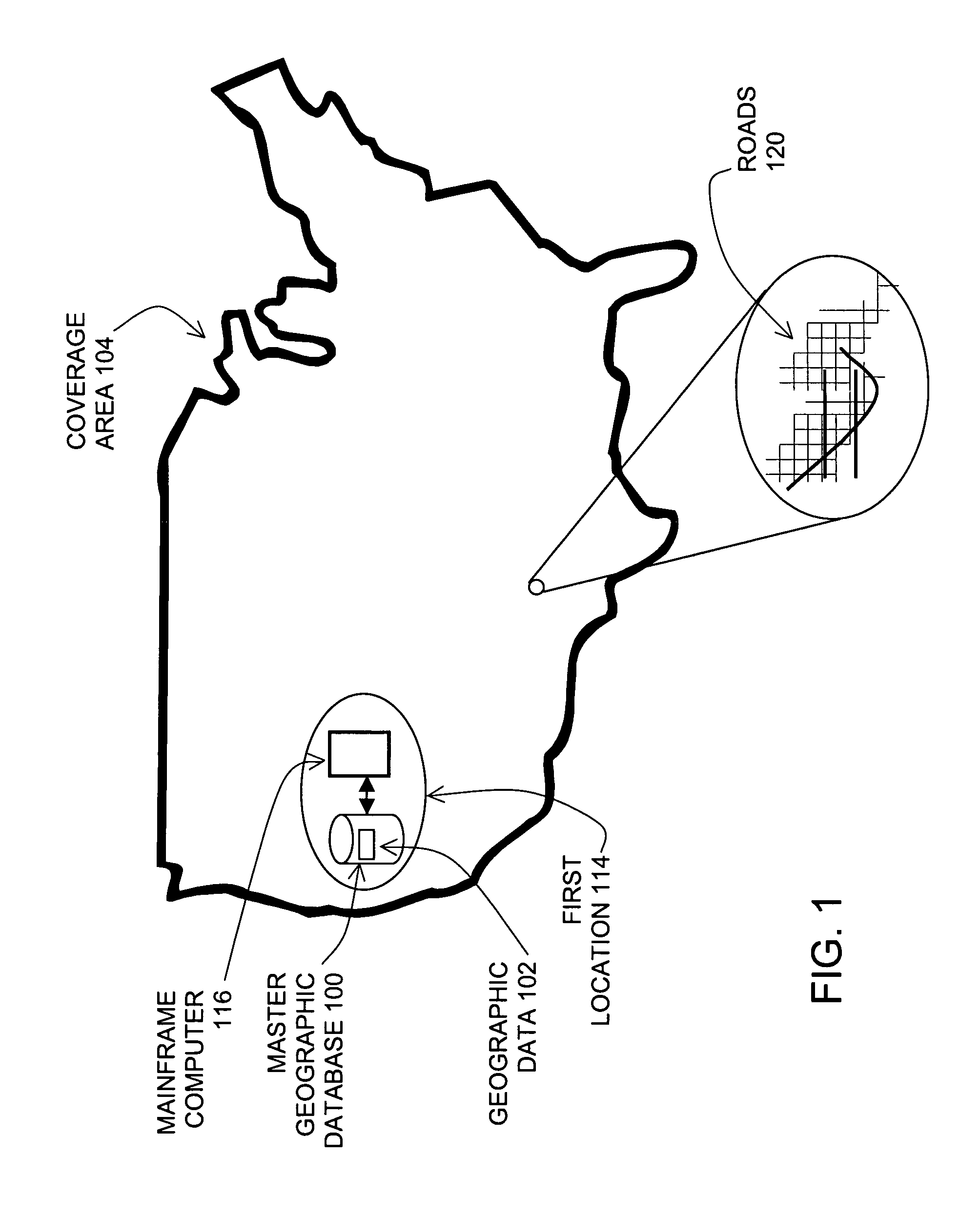
[0025]The compiled database products 110 may include only portions of all the data in the master version of the geographic database 100. For example, the compiled database products 110 may include data that relate to only one or more specific sub-areas within the coverage area 104 of the master version of the geographic database 100. Further, the compiled database products 110 may include fewer than all the data attributes that describe geographic features represented in the master version of ...

second embodiment

IV. Second Embodiment

[0058]FIG. 5 shows another embodiment of a system and method for facilitating the development of computer games that include representations of actual geographic features, such as roads, in a geographic area. In FIG. 5, like components are indicated by the same numerals as in the previous embodiment. The system and method of FIG. 5 are similar to the system and method of FIG. 2 with the exception that the game developer 130 receives geographic data from the master geographic database 100 instead of from one of the compiled geographic databases 110, 118 produced from the master geographic database 100. In order to access data from the master geographic database 100, the game developer 130 uses an interface 200. The interface 200 is different from the API 140 (in FIG. 4) insofar as it provides for accessing geographic data in the uncompressed format in which it is stored in the master geographic database 100. This may affect the performance of the interface 200. H...

third embodiment

V. Third Embodiment

[0059]FIG. 6 shows another embodiment of a system and method for facilitating the development of computer games that include representations of actual geographic features, such as roads, in a geographic area. In FIG. 7, like components are indicated by the same numerals as in the previous embodiment. The system and method of FIG. 7 are similar to the system and method of FIG. 2 with the exception that the map developer 101 provides compiled geographic database products 220 which are suitable for use in computer platforms for games 134. These compiled geographic database products 220 are then distributed to end users who use the compiled geographic database products 220 in their computing platforms for games 134. The compiled geographic database products 220 may be distributed directly from the map developer 101 to the end users or alternatively, the compiled geographic database products 220 may be distributed through the computer game developer 130 or another thir...


PUM


Abstract

A system and method are disclosed for facilitating development of computer games that depict or represent actual, real world geographic areas as part of the play scenarios of the games. A source database contains data that represent geographic features in a region including roads in the region. The data in the source database includes attributes suitable for use for providing navigation-related functions. In addition to providing data from the source database for navigation-related functions, data from the source database are also provided for computer game development. An application programming interface, as well as other tools for handling geographic data, is provided for accessing and processing of the geographic data.

Description

REFERENCE TO RELATED APPLICATIONS[0001]The present application is related to the patent applications entitled “APPLICATION PROGRAMMING INTERFACE FOR GEOGRAPHIC DATA IN COMPUTER GAMES”, application Ser. No. 10 / 798,531 filed Mar. 11, 2004 (now U.S. Pat. No. 7,828,655), “GEOGRAPHIC AREA TEMPLATES FOR COMPUTER GAMES”, application Ser. No. 10 / 798,632 filed Mar. 11, 2004, and “COMPUTER GAME DEVELOPMENT FACTORY SYSTEM AND METHOD”, application Ser. No. 10 / 798,703 filed Mar. 11, 2004, the entire disclosures of which are incorporated by reference herein.BACKGROUND OF THE INVENTION[0002]The present invention relates to a system and method that facilitate development of computer games and more particularly, a system and method that facilitate development of computer games that include representations of actual real world geographic areas, such as the road networks in the geographic areas.[0003]Computer games have developed in sophistication and commercial importance. Improvements in computer ha...

Claims


Application Information

Patent Timeline
Patent Type & Authority Patents(United States)
IPC IPC(8): G06F17/30A63F13/10A63F13/12G01C21/00G01C21/26
CPCA63F13/10G01C21/26A63F2300/6009Y10S707/919A63F2300/6018A63F13/45A63F13/65A63F13/63
Inventor UHLIR, KURT BROOKSDOUGHERTY, CHRISTOPHERSHUMAN, MICHAEL V.CASINO, ROY
Owner HERE GLOBAL BV
Why Eureka
Try Eureka