Device and method for extracting terrain altitudes

a technology of terrain altitude and equipment, applied in the field of equipment and equipment for extracting terrain altitude, can solve the problems of embedded computers that are often limited in calculation time and memory, embedded computers occupy a great deal of space, and the utilization of terrain data is very expensive in terms of calculation time for embedded computer processors, so as to achieve precise and robust results and optimize calculation times

Active Publication Date: 2011-12-06
THALES SA
View PDF6 Cites 7 Cited by
  • Summary
  • Abstract
  • Description
  • Claims
  • Application Information

AI Technical Summary

Benefits of technology

The main advantages of the invention are notably that it gives precise and robust results, while optimizing the calculation times.

Problems solved by technology

Such data occupy a great deal of room in a memory of an embedded computer onboard the aircraft.
Moreover, utilization of the terrain data is very expensive in terms of calculation time for embedded-computer processors.
Embedded computers are often limited in terms of calculation time and memory on account notably of the considerable amount of data to be processed in real time.
These modes of operation therefore do not allow the pilot to anticipate avoidance manoeuvres.
These avoidance manoeuvres are then carried out as a matter of urgency and therefore to the detriment of passenger comfort and with a risk of the manoeuvre failing if a technical problem arises at that moment.
As regards the terrain display mode, even though it performs presentation of the terrain over a large distance, this is to the detriment of the precision of the information taken into account.

Method used


Image

  • Device and method for extracting terrain altitudes
  • Device and method for extracting terrain altitudes
  • Device and method for extracting terrain altitudes

Examples


Embodiment Construction

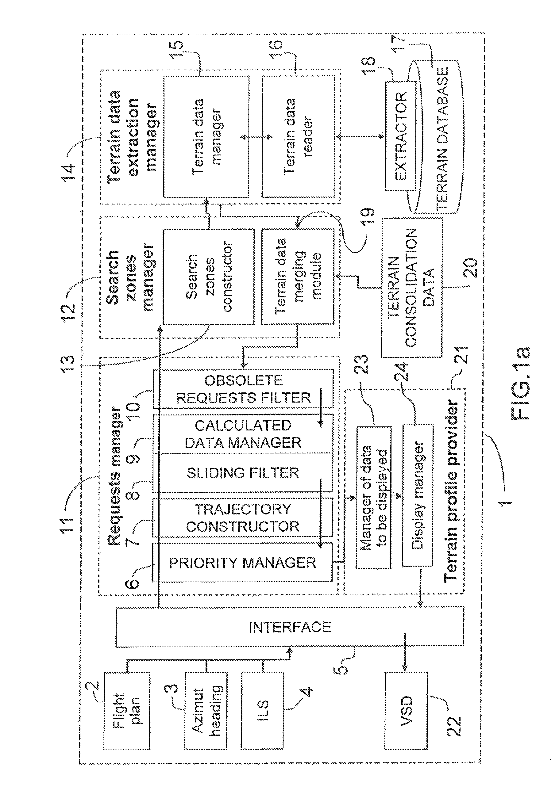
FIG. 1a represents an example of an architecture of a device for extracting terrain altitudes 1 according to the invention.

The device for extracting terrain altitudes 1 can be used notably aboard an aircraft to supplement a TAWS system for example. It can make it possible to display on a screen a view of a terrain profile along a trajectory of an aircraft. A trajectory of an aircraft can emanate from position, altitude and heading data forming part notably of a flight plan of the aircraft. A trajectory can be represented for example in the form of a succession of points linked by segments. The display of the trajectory with a profile of the terrain overflown can allow a pilot of the aircraft, for example, to ascertain the position of the aircraft with respect to the ground over the whole of the trajectory or over a part of the trajectory, over a given temporal horizon for example. The pilot can thus possibly anticipate terrain avoidance manoeuvres in the event of too close proximity...


PUM


Abstract

The present invention relates to a method and a device for extracting terrain altitudes notably for a display of a sectional view of a terrain overflown by an aircraft. The device for extracting terrain altitudes along a trajectory of an aircraft in flight includes an interface taking into account selected flight parameters of the aircraft; a terrain altitudes extraction requests manager; a geographical zones manager; a terrain data manager; a terrain profile provider. The disclosed embodiment is configured to be used within the framework of an anticollision device for preventing collision between an aircraft and the terrain.

Description

RELATED APPLICATIONSThe present application is based on, and claims priority from, French Application Number 07 03388, filed May 11, 2007, the disclosure of which is hereby incorporated by reference herein in its entiretyBACKGROUND OF THE INVENTIONThe present invention relates to a device and a method for extracting terrain altitudes notably for a display of a sectional view of a terrain overflown by an aircraft. The invention can notably be used within the framework of an anticollision device for preventing collision between an aircraft and the terrain.DESCRIPTION OF THE PRIOR ARTWith the objective of guaranteeing greater safety of aircraft in flight, systems such as TAWS, the initials standing for Terrain Awareness and Warning System, make it possible notably to warn a pilot of an aircraft of the imminence of a collision with the terrain. TAWS systems can have several modes of operation:a first mode, called the reactive mode, makes it possible on the basis of the current position ...

Claims


Application Information

Patent Timeline
Patent Type & Authority Patents(United States)
IPC IPC(8): G05D1/04G06F17/00G01S13/935
CPCG01C5/005G08G5/0021G08G5/0086
Inventor MARTY, NICOLASPERCIER, JULIASALLIER, AURELIE
Owner THALES SA
Why Eureka
Try Eureka