Method for determination of stand attributes and a computer program for performing the method

a computer program and attribute technology, applied in the field of forest inventory and attribute determination, can solve problems such as the amount of dense laser pulses

Active Publication Date: 2012-06-26
FM KARTTA +1
View PDF10 Cites 33 Cited by
  • Summary
  • Abstract
  • Description
  • Claims
  • Application Information

AI Technical Summary

Benefits of technology

[0018]There are clear gaps between the tree crowns in the northern boreal forest zone, many commercially exploited forest areas and also other forest areas. In Finland, ca 30% of the laser pulses are reflected from the ground. The invention presented in the Finnish patent FI 112402 made use of this fact in such a way that individual trees could be measured by means of a large number of laser scanner pulses. This invention makes use of said fact in that way that samples from the ground can be achieved with a relatively low number of pulses, which enables the production of a rough but sufficiently accurate Digital Terrain Model (DTM). A digital terrain model with the accuracy of usually 0.5 m can be produced with a laser scanner even with a small number of pulses. The accuracy is sufficient with respect to forest inventory at stand level.
[0020]The point cloud produced by laser scanning and the image information shall be brought into the same coordinate system, so that the information from different sources can be combined to belong to the same target. Known equations for conversion between different coordinate systems are used for the conversion of the coordinates. The compatibility is further improved by identifying, from the different materials, groups of corresponding targets that clearly can be discriminated from the surroundings and by calculating from these targets a parametric conversion model by means of regression analysis.
[0024]The present invention avoids the condition of a dense number of laser pulses. It is more cost effective to conduct laser scanning surveys from higher altitudes to provide a wider coverage. On the other hand, the density of the points from the target is reduced. This reduction can be compensated by taking aerial images and by densifying the laser point clouds by using an aerial image block. A solution like this has not been used anywhere before. The costs of aerial photography are just a fraction of those of laser scanning.
[0025]The method of this invention is the cheapest of all such remote recognition methods for forest inventory which produce stand attribute information with an accuracy of 15%. The advantage of the invention compared to typical remote sensing methods is also that, with the method of the invention clear physical characteristics are measured from the object, in the form of ranging data, for which tree attributes, such as the volume, can be derived. Thus, the method does not necessary require the use of sample plots as teaching material, which decreases the costs for the method.

Problems solved by technology

The method requires, however, a considerably dense laser pulse amount for the separation of individual trees merely by means of laser information.

Method used


Image

  • Method for determination of stand attributes and a computer program for performing the method
  • Method for determination of stand attributes and a computer program for performing the method
  • Method for determination of stand attributes and a computer program for performing the method

Examples


Embodiment Construction

Performing of Laser Scanning and Production of a High Resolution Aerial Image Block from the Forest Area

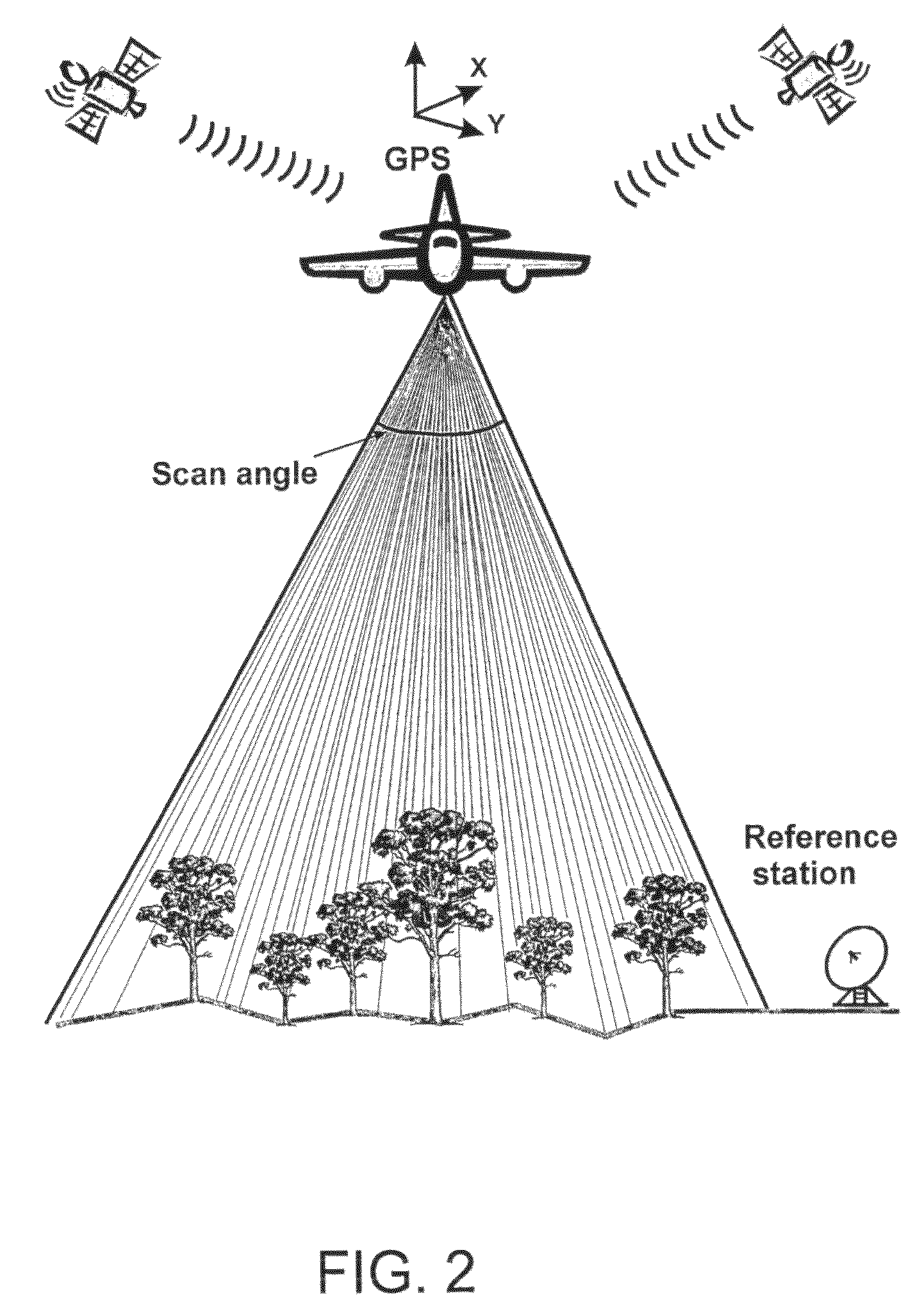
[0041]FIGS. 1 and 2 present a general view of the measuring situation in the method. Both the laser measurement and the aerial photography are performed from a flying platform (an air plane, a helicopter, an unmanned aircraft, a remotely piloted aerial vehicle) above the stand. Of these, an airplane is for the time being the best vehicle for flat areas, a helicopter on mountain areas and the cheapest one is an automatically controlled unmanned aircraft or remotely piloted aerial vehicle. The devices (the laser scanner and the camera for taking aerial images) can either be in the flying vehicle taking simultaneous images or the fights can be done at different times. The advantage with doing the measurements at the same time is that the materials can be georeferenced with the same GPS / IMU observations and they are also otherwise geometrically closer to each other. Also the flight co...


PUM


Abstract

The method is for forest inventory and for determination of stand attributes. Stand information of trees, sample plots, stands and larger forest areas can be determined by measuring or deriving the most important attributes for individual trees. The method uses a laser scanner and overlapping images. A densification of the laser point clouds is performed and the achieved denser point clouds are used to identify individual trees and groups of trees. A computer program is used for performing the method.

Description

PRIOR APPLICATIONS[0001]This is a US national phase patent application that claims priority from PCT / FI2005 / 000150, filed 14 Mar. 2005, that claims priority from Finnish Patent Application No. 20040396, filed 15 Mar. 2004.TECHNICAL FIELD[0002]The invention is concerned with a method for forest inventory and determination of stand attributes. With the method, stand attributes of individual trees, sample plots, stands or larger forest areas can be determined by measuring or deriving the most important attributes of individual trees. The invention is also concerned with a computer program for performing the method.BACKGROUND ART[0003]Conventional forest inventory is still mostly based on field measurements. E.g. forest inventory at stand level, in which the forest is first divided into almost homogeneous compartments (typically of the size of 1-3 hectares), is presently based on plot measurement and visual observations. Aerial photographs and orthophotos (aerial images rectified to map...

Claims


Application Information

Patent Timeline
Patent Type & Authority Patents(United States)
IPC IPC(8): G06K9/00G01B11/00G01B11/24G01C11/02G01S7/481G01S17/88G01S17/894G06V20/13
CPCG01C11/025G06K9/0063G06V20/13
Inventor SAVOLAINEN, PEKKALUUKKONEN, HEIKKIHYYPPA, JUHAHONKAVAARA, EIJAYU, XIAOWEIKUKKO, ANTERO
Owner FM KARTTA
Why Eureka
Try Eureka