Method of capturing linear features along a reference-line across a surface for use in a map database

a technology of a reference line and a map database, which is applied in the field of producing linear features along a reference line across a surface for use in a map database, can solve the problems of more time and effort, complex algorithms, and more complex filters than filters for detecting vertical or horizontal, and achieve the effect of decreasing the number of image lines

Active Publication Date: 2013-01-08
TOMTOM GLOBAL CONTENT
View PDF2 Cites 16 Cited by
  • Summary
  • Abstract
  • Description
  • Claims
  • Application Information

AI Technical Summary

Benefits of technology

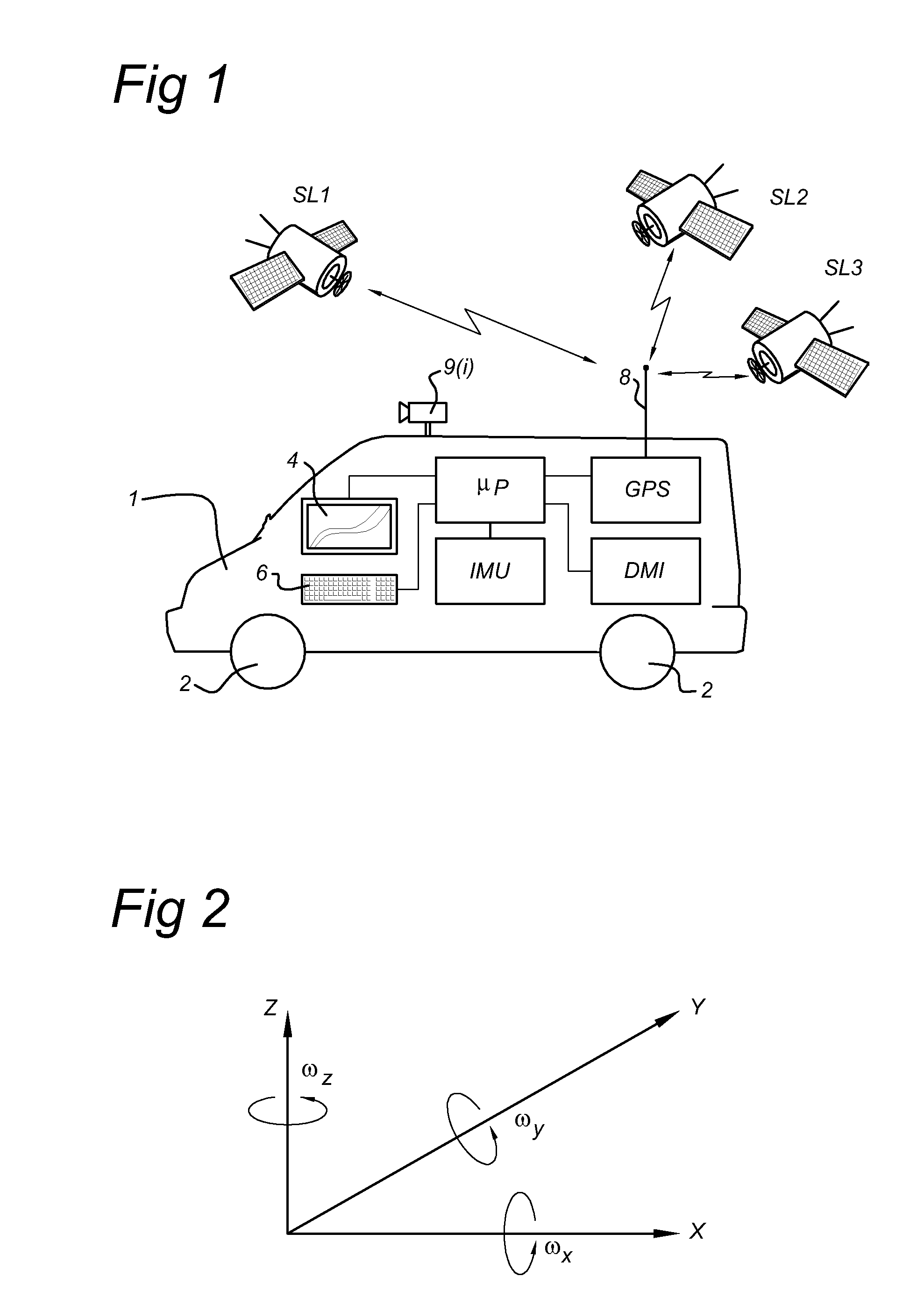
[0023]The invention is based on the recognition that linear road information, such as lane dividers, road sides, road centerline etc., is road information which is parallel to the direction of the road. The direction of a road can be obtained from a map database. Furthermore, the driving direction of a vehicle on a road is a good approximation of the direction of a road. The position and orientation of the vehicle is determined by means of a GPS receiver and an inertial measuring device, such as one or more gyroscopes and / or accelerometers. In this way a track-line of the vehicle can be made in a geographic coordinate reference system. The track-line is a good approximation of the direction of the road. On an orthorectified image, a road and thus the track-line of a vehicle or linear road information will be curved. The idea is to transform the area along a reference-line, for example the track-line of a vehicle, in the orthorectified image into a reference-line referenced image wherein the reference-line and areas parallel to the reference-line are a straight line and rectangles along the straight line. In this way, a curved road with constant width will be transformed into an image of an almost straight road with almost parallel road sides, a reference-line according to a centerline or lane markings will be almost straight lines in a reference-line referenced image. The degree of straightness of the linear features in the reference-line referenced image depends on the accuracy of the position of the reference-line with respect to the linear features. If the vehicle drives always in the middle of one lane, the linear features will be substantially straight. However, if the vehicle changes lanes, he will cross a lane divider, this will be seen as a horizontal change of the lane divider in subsequent rows of pixels in the reference-line referenced image. As stated above the linear features in such an image are much easier and faster to digitize or verify by a human then would be the case when using the original orthorectified image. As the performed transformation is reversible, the exact geo-position of a linear feature can be derived from the positions of a feature determined in the reference-line referenced (straight line) image. The orthorectified geo-referenced space to reference-line referenced image space (RRI Space) transformation allows a human to analyze at least 20 times more information at one time. Another advantage of a reference-line referenced image is that the human analyzing the road surface only needs to scroll up and down in the image to move along the road surface, whereas he has to scroll in 2-dimensions in the image if he would like to move along the road on an orthorectified image. In this way, the human can move fast along the road surface to located a required position.
[0025]By means of the invention, the linear road information of a particular area, e.g. roads within a region, can be captured or edited much faster. This reduces the cost to manufacture the information, but also reduces the time between capturing the images and providing the road information to a customer. The invention further enables digital map providers to provide more frequently updates of a digital map.
[0034]In an embodiment of the invention, the sample positions are equidistant along the reference-line. This feature allows a software program to provide without transformation a reference-line referenced image which is easy to interpret by a human.
[0069]Reference-line referenced images according to the invention, enables humans to verify efficiently and easily the positions of linear features in existing map databases. The position of a linear feature, e.g. lane divider, taken from an existing map database can be used as reference-line. The orthorectified images visualizes the real surface of the earth when projected on the ellipsoid that approximates the shape of the earth used by a geographic coordinate reference system. In the reference-line referenced image, the linear feature should be visual on a predefined position in the image. Furthermore, a linear feature should be a straight line. If the position is incorrect or the linear feature is not a straight line, a human will recognize this as a defect and could mark the defect. Subsequently, the geo-position of the defect is determined by the projected coordinate reference system associated with the pixels of the reference-line referenced image. The geo-positions of the defects can be used to retrieve corresponding source images from a mobile mapping vehicle or a corresponding orthorectified image, to digitize again the linear feature in the images with relative high resolution. In this way, data in existing map databases can be verified efficiently and corrected if necessary.

Problems solved by technology

Therefore, the more curvy a road the more time is effort is needed to retrieve the horizontal road information from the images.
Similarly, the more curvy a road the more complex algorithms are needed to retrieve the horizontal road information from orthorectified images.
Secondly, the road markings have to be found on the road surface in the image.
These filters are more complex then filters for detecting vertical or horizontal lines / edges only.
Both refreshing the image and digitizing one point are time consuming.

Method used


Image

  • Method of capturing linear features along a reference-line across a surface for use in a map database
  • Method of capturing linear features along a reference-line across a surface for use in a map database
  • Method of capturing linear features along a reference-line across a surface for use in a map database

Examples


Embodiment Construction

[0083]FIG. 1 shows a MMS system that takes the form of a car 1. The car 1 is provided with one or more cameras 9(i), i=1, 2, 3, . . . I. The looking angle or the one or more cameras 9(i) can be in any direction with respect to the driving direction of the car 1 and can thus be a front looking camera, a side looking camera or rear looking camera, etc. The viewing window(s) of the camera(s) 9(i) cover(s) the whole road surface in front the vehicle. Preferably, the angle between the driving direction of the car 1 and the looking angle of a camera is within the range of 45 degree-135 degree on either side. The car 1 can be driven by a driver along roads of interest.

[0084]The car 1 is provided with a plurality of wheels 2. Moreover, the car 1 is provided with a high accuracy position determination device. As shown in FIG. 1, the position determination device comprises the following components:[0085]a GPS (global positioning system) unit connected to an antenna 8 and arranged to communica...


PUM


Abstract

A method of producing linear features along a reference-line across a surface for use in a map database is disclosed. In at least one embodiment, the method includes generating, from reference-line data representative of coordinates of the reference-line in a geographic coordinate reference system and source images of the surface adjacent to the reference-line and associated position and orientation data in the geographic coordinate reference system, a reference-line referenced data set, wherein the reference-line referenced data set includes a plurality of sets of image data and associated data defining a reference-line' across a surface in the geographic coordinate reference system, the sets of image data including pixels wherein a set of image data corresponds to an orthorectified view representation of a line section of the surface in the geographic coordinate reference system, each set of image data includes a reference pixel being associated with a position on the reference-line, wherein each pixel represents a surface having a position at a distance from the position of the reference pixel along the line section, and wherein the line section perpendicularly crosses the reference-line at the position associated with the reference pixel; and, post processing the reference-line referenced data set to produce linear features along the reference-line and associated locations in the geographic coordinate reference system for use in a map database.

Description

FIELD OF THE INVENTION[0001]The present invention relates to a method of producing linear features along a reference-line across a surface for use in a map database. The invention further relates to a method of generating a reference-line referenced data set and a method of post processing a reference-line referenced data set to produce linear features along a reference-line across a surface and associated locations in a coordinate system for use in a map database. Moreover, the invention relates to a reference-line referenced data set, a computer implemented system for producing or verifying linear features, a computer program product and a processor readable medium carrying said computer program product or reference-line referenced data set.PRIOR ART[0002]There is a need to collect a large number of linear road information e.g. lane dividers, road centrelines, road width etc. for digital map databases used in navigation systems and the like. The geo-position of the road informatio...

Claims


Application Information

Patent Timeline
Patent Type & Authority Patents(United States)
IPC IPC(8): G06K9/46
CPCG01C21/32G06T3/0043G06T2207/30256G01C21/3819G01C21/3852
Inventor KMIECIK, MARCIN MICHALNOWAK, WOJCIECH TOMASZ
Owner TOMTOM GLOBAL CONTENT
Why Eureka
Try Eureka