Autonomous cooperative surveying

a cooperative surveying and autonomous technology, applied in the direction of navigation instruments, instruments, wave based measurement systems, etc., can solve the problems of high cost associated with the procurement and operation of vehicles and equipment involved, preventing optimal safety and navigational efficiency, and lack of current knowledge of earth's land elevation features

Active Publication Date: 2013-04-09
SURVICE ENG
View PDF11 Cites 20 Cited by
  • Summary
  • Abstract
  • Description
  • Claims
  • Application Information

AI Technical Summary

Problems solved by technology

For example, the lack of the most current and accurate subsurface terrain data (e.g., channel depth as a function of position) at the time of a ship's transit introduces a level of uncertainty that prevents optimal safety and navigational efficiency.
Similar mobility impacts result from the lack of current knowledge of the earth's land elevation features.
These missions provide for the acquisition of very accurate measurements, but do so at high cost associated with procurement and operation of the vehicles and equipment involved.
Budget and time constraints often limit proper survey efforts to a limited number of desired mapping areas.
In the end, the lack of, or excessive latency in the delivery of updated information results in occasional grounding accidents and creates the potential for significant environmental dangers.

Method used


Image

  • Autonomous cooperative surveying
  • Autonomous cooperative surveying
  • Autonomous cooperative surveying

Examples


Embodiment Construction

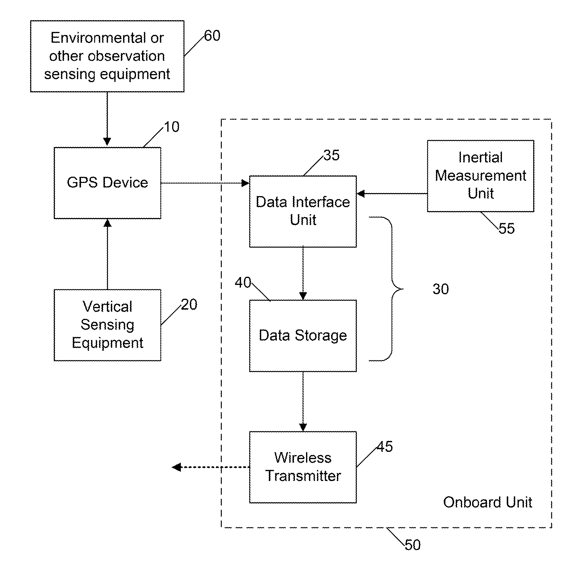
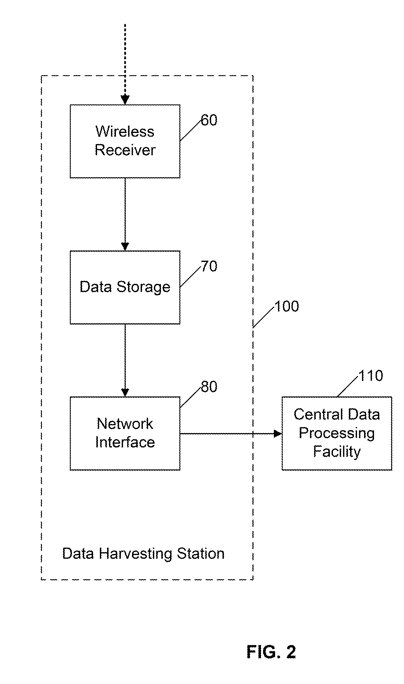
[0024]Certain embodiments as disclosed herein provide for a method and apparatus for measuring the elevation of land features and the depth of waterways through autonomous consolidation of three-dimensional positioning data acquired from multiple mobile platforms (e.g., personnel, vehicles, vessels, aircraft). The positioning data may then be processed and compared to published reference data. When discrepancies / variances appear between the processed elevation data and published reference data, a recommendation may be issued that a more thorough investigation of a particular area or shipping channel should be conducted.

[0025]After reading this description it will become apparent to one skilled in the art how to implement the invention in various alternative embodiments and alternative applications. However, although various embodiments of the present invention will be described herein, it is understood that these embodiments are presented by way of example only, and not limitations....


PUM


Abstract

A method and apparatus for measuring depth of waterways and elevation of land features through autonomous consolidation of GPS device data acquired from a plurality of mobile platforms is disclosed. The GPS device data may then be processed and compared to published reference data. A data recorder and a wireless transmission system comprise an onboard unit, which serves to interface with the GPS device for collecting, recording and transmitting data. The onboard device also provides an apparatus for collecting other georeferenced data from multiple mobile platforms, and serves as a node on a two-way meshed communication network.

Description

RELATED APPLICATIONS[0001]This application claims the benefit of U.S. provisional applications Ser. No. 61 / 120,734, filed Dec. 8, 2008, entitled “AUTONOMOUS HYDROGRAPIC SURVEYS,” and Ser. No. 61 / 223,336, filed Jul. 6, 2009 entitled “AUTONOMOUS COOPERATIVE SURVEYING,” which are hereby incorporated by reference.BACKGROUND[0002]1. Field of the Invention[0003]The present invention relates generally to a means for collecting and processing geographical contour data used to create or update contour maps documenting land-based (topographic) and sea-based (hydrographic) elevation and depth features. In particular, the present invention provides for contour mapping utilizing horizontal position-based sensors, such as global positioning system (“GPS”) based sensors, coupled with an elevation or depth measuring sensor, such as augmented GPS, radar altimetry, or sonar, applied to a quantity of mobile air, land, or sea platforms engaged in routine activities.[0004]2. Related Art[0005]The topogra...

Claims


Application Information

Patent Timeline
Patent Type & Authority Patents(United States)
IPC IPC(8): G01C21/00
CPCG01C13/008G01C21/32G01S19/49Y02A90/30G01S19/45G01C21/3848
Inventor HERSEY, JOHN A.HERSEY, III, WILLIAM J.
Owner SURVICE ENG
Why Eureka
Try Eureka