Automatic city block segmentation in aerial imagery for parallel processing

a technology of aerial imagery and parallel processing, applied in the field of parallel processing of aerial imagery, can solve the problems of large data sets of images to be processed, deficient methods, and special problems of traditional approaches

Active Publication Date: 2013-08-27
GOOGLE LLC
View PDF2 Cites 11 Cited by
  • Summary
  • Abstract
  • Description
  • Claims
  • Application Information

AI Technical Summary

Benefits of technology

[0008]An example system comprises a feature mask generation module, a partition generation module, one or more color map generation modules, a color map reassignment module, and a bounding box generation module.
[0009]The feature mask generation module is configured to use vector map data to generate a feature mask, comprising road segments, that is aligned with aerial image data corresponding to a geographic region of interest. The partition generation module is configured to partition aerial image data and the corresponding feature mask into tiles such that the data within a given tile is suitably partitioned for parallel processing. One or more color map generation modules are configured to generate a color map for each tile, wherein the color map comprises a plurality of pre-defined regions in which each pre-defined region can be defined by enclosing road segments. In a given color map, each pre-defined region is assigned a single uniform color. The color map reassignment module is configured to generate a composite color map for the entire geographic region of interest by comparing color maps of adjacent tiles and reassigning colors as needed so that pre-defined regions, split by tile boundaries, become uniformly colored contiguously across tile boundaries. In this way, tile boundaries are removed. The bounding box generator is configured to generate a segmentation of the aerial imagery for the entire geographic region of interest by computing and storing bounding boxes for the pre-defined regions in the composite color map after removing regions that are either too large or too small to be pre-defined regions.

Problems solved by technology

One problem encountered in the field of aerial imagery is the need to break up enormous data sets for processing of images.
These methods are deficient because they break up or degrade the image structures.
Traditional approaches are especially problematic when dealing with images of a city.
Problems arise when an image is broken up into segments called tiles, and structures span the tiles.
For example, if a building or a bridge is split amongst two tiles, it can be a difficult problem to stitch the image back together.

Method used


Image

  • Automatic city block segmentation in aerial imagery for parallel processing
  • Automatic city block segmentation in aerial imagery for parallel processing
  • Automatic city block segmentation in aerial imagery for parallel processing

Examples


Embodiment Construction

[0022]Reference in this specification to “one embodiment,”“an embodiment,” and “an example embodiment,” etc., indicate that the embodiment described may include a particular feature, structure or characteristic but not every embodiment may necessarily include the particular feature, structure or characteristic. Moreover, such phrases are not necessarily referring to the same embodiment. Further, when a particular feature, structure or characteristic is described in connection with an embodiment, it is submitted that it is within the knowledge of one skilled in the art to effect such structure, feature, or characteristic in connection with other embodiments whether or not explicitly described. Embodiments will be described with reference to the accompanying figures.

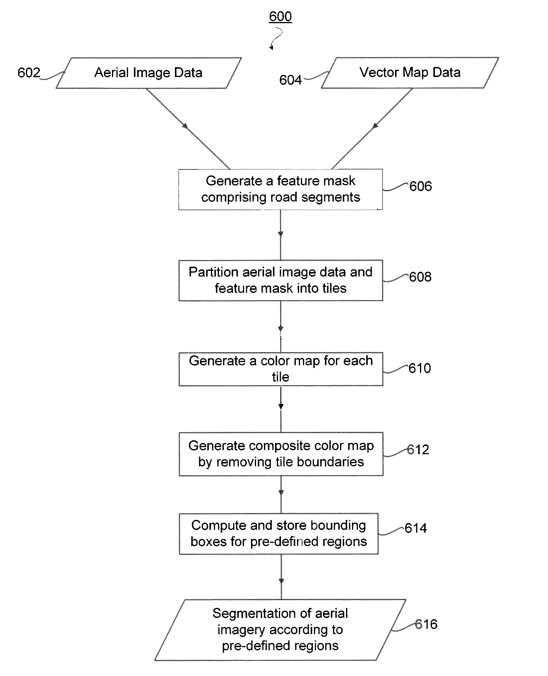
[0023]This disclosure provides systems and methods for segmenting large data sets corresponding to aerial imagery according to pre-defined regions in the images such as city blocks. The systems and methods overcome problem...


PUM


Abstract

A computer implemented system and method are disclosed for segmenting aerial and satellite imagery according to pre-defined regions contained in the images such as city blocks. An example system comprises a feature mask generation module, a partition generation module, one or more color map generation modules, a color map reassignment module, and a bounding box generation module. The system and method take aerial image data and vector map data as input and generate a composite color map for a geographic region of interest, wherein the color map comprises a plurality of pre-defined regions in which each pre-defined region can be defined by enclosing road segments. The disclosed system and method provide a convenient and logical way of segmenting large data sets of aerial imagery for use in other applications such as the construction of computer models of surface features of the Earth.

Description

BACKGROUND[0001]1. Field[0002]This disclosure relates to systems and methods for combining satellite and aerial imagery with map data wherein data is segmented according to predefined regions such that the data is suitably partitioned for parallel processing.[0003]2. Background Art[0004]The field of aerial imagery is concerned with capturing photographs of land masses over large areas. Aerial photographs are often combined. For example, a panoramic image can be made by stitching several photographs together. Large sets of aerial or satellite photographs can be combined and used in online map systems. Another area in which aerial imagery is used is in the field of Geographic Information Systems (GIS). A Geographic Information System or Geospatial Information System is any system that presents data specifically associated with spatial locations. An example of a GIS system is a system that correlates aerial or satellite images with maps.[0005]One problem encountered in the field of aer...

Claims


Application Information

Patent Timeline
Patent Type & Authority Patents(United States)
IPC IPC(8): G06K9/00G06V20/13
CPCG06T7/0081G06K9/0063G06T7/0097G06T2207/10032G06T2207/30184G06T7/11G06T7/174G06V20/13
Inventor SCHPOK, JOSHUACHILDS, JEREMIAHREINHARDT, TILMAN
Owner GOOGLE LLC
Why Eureka
Try Eureka