Method and system for gamma-ray localization induced spacecraft navigation using celestial gamma-ray sources

a technology of gamma-ray localization and spacecraft, applied in the direction of navigation, instruments, surveying and navigation, etc., can solve the problems of increasing mission scheduling and operational costs, many x-ray pulsars are faint, and the existing system cannot provide this additional service, etc., to increase the on-board navigation and guidance capability, enhance position accuracy, and increase the accuracy

Active Publication Date: 2015-09-22
ASTER LABS
View PDF2 Cites 12 Cited by
  • Summary
  • Abstract
  • Description
  • Claims
  • Application Information

AI Technical Summary

Benefits of technology

[0033]It is another object of the present invention to provide a new technique for an accurate computation of a relative range between two spacecraft locations based on processing of assemblages of gamma-ray photons arriving from distant gamma-ray bursts (GRBs), along the direction to the GRB based upon the difference in arrival time of the burst emission at each spacecraft's location.
[0034]In addition, it is an object of the present invention to provide a navigation system using correlation techniques for time-alignment of the high-energy burst profiles detected by the detectors mounted at the vehicle of interest and the base station, to compute navigation solutions based on the time difference of arrival of the gamma-ray photons at the respective detecting systems, and augmented with an error correction sub-system that continuously updates the computed navigation data for highly accurate navigation of the vehicle of interest.
[0035]To address the challenges of future DSN operations and enhance position accuracy for deep space vehicles, a novel relative navigation technology for deep-space exploration using measurements of celestial gamma-ray sources has been developed that incorporates existing designs of autonomous navigation technologies and merges this with the developing science of high energy sensor components. This new technology for interplanetary self-navigation referred to herein as Gamma-Ray Source Localization-Induced Navigation and Timing, also referred to as GLINT, provides important enhancements to planned exploration and discovery missions, specifically by increasing the on-board navigation and guidance capability, thereby reducing operational requirements.
[0040]A significant advantage supporting the GLINT implementation is that gamma-ray detectors are currently incorporated on almost all deep space missions and science missions in Earth's orbit, as part of their instrument package. These detectors support the science investigations of space radiation, as well as validation of the composition of elements on planetary bodies.
[0042]An initial study using past and current observed gamma-ray mission data has demonstrated that the relative navigation performance of hundreds of kilometer accuracy is readily available. However, sub-kilometer level positioning is expected to be achieved by the GLINT system using enhanced photon timing and processing algorithms.
[0061]In the GLINT system, the gamma-ray detector sub-system preferably includes a scintillator unit, a photon timing board, and an atomic clock operatively interconnected each to the other to produce data including time-tagged photons and photon energies responsive to detection of the target GRB. The gamma-ray detector sub-system preferably includes also an X-ray detector. Where possible, an X-ray detector integrated into the GLINT system can augment the solution, and possibly increase the frequency of observation, using the same method of finding the relative position solution.

Problems solved by technology

For space vehicles venturing beyond Earth orbit into deep space, current methods require frequent interaction and communication with Earth stations, which can significantly increase mission scheduling and operational costs.
However, as exploration initiatives increase and operational usage expands, the DSN has the potential for over-subscription due to its many ongoing and future planned missions, and thus stands to benefit from supplemental navigation augmentation capabilities designed to reduce DSN operations cost.
Very few existing systems can provide this additional service while reducing DSN workload.
A shortcoming of the XNAV technique is that many X-ray pulsars are faint and require extended observation times to generate sufficient usable data.
These low photon flux rates make the use of γ-ray pulsars an extreme challenge for a practical navigation system.

Method used


Image

  • Method and system for gamma-ray localization induced spacecraft navigation using celestial gamma-ray sources
  • Method and system for gamma-ray localization induced spacecraft navigation using celestial gamma-ray sources
  • Method and system for gamma-ray localization induced spacecraft navigation using celestial gamma-ray sources

Examples


Embodiment Construction

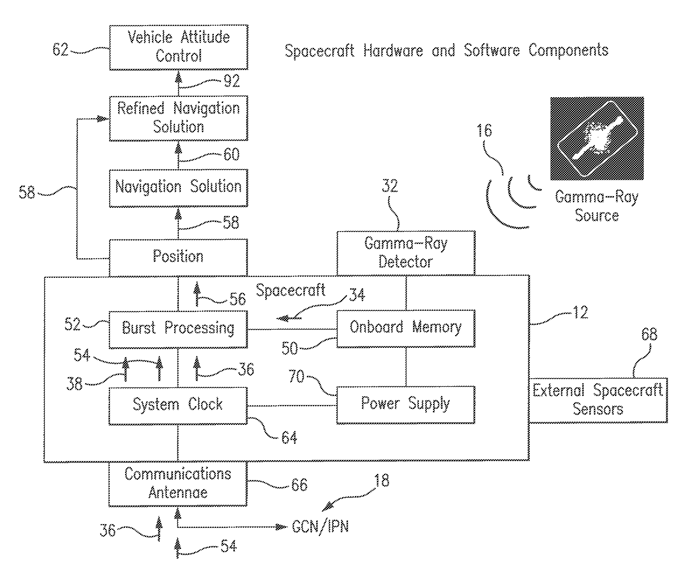
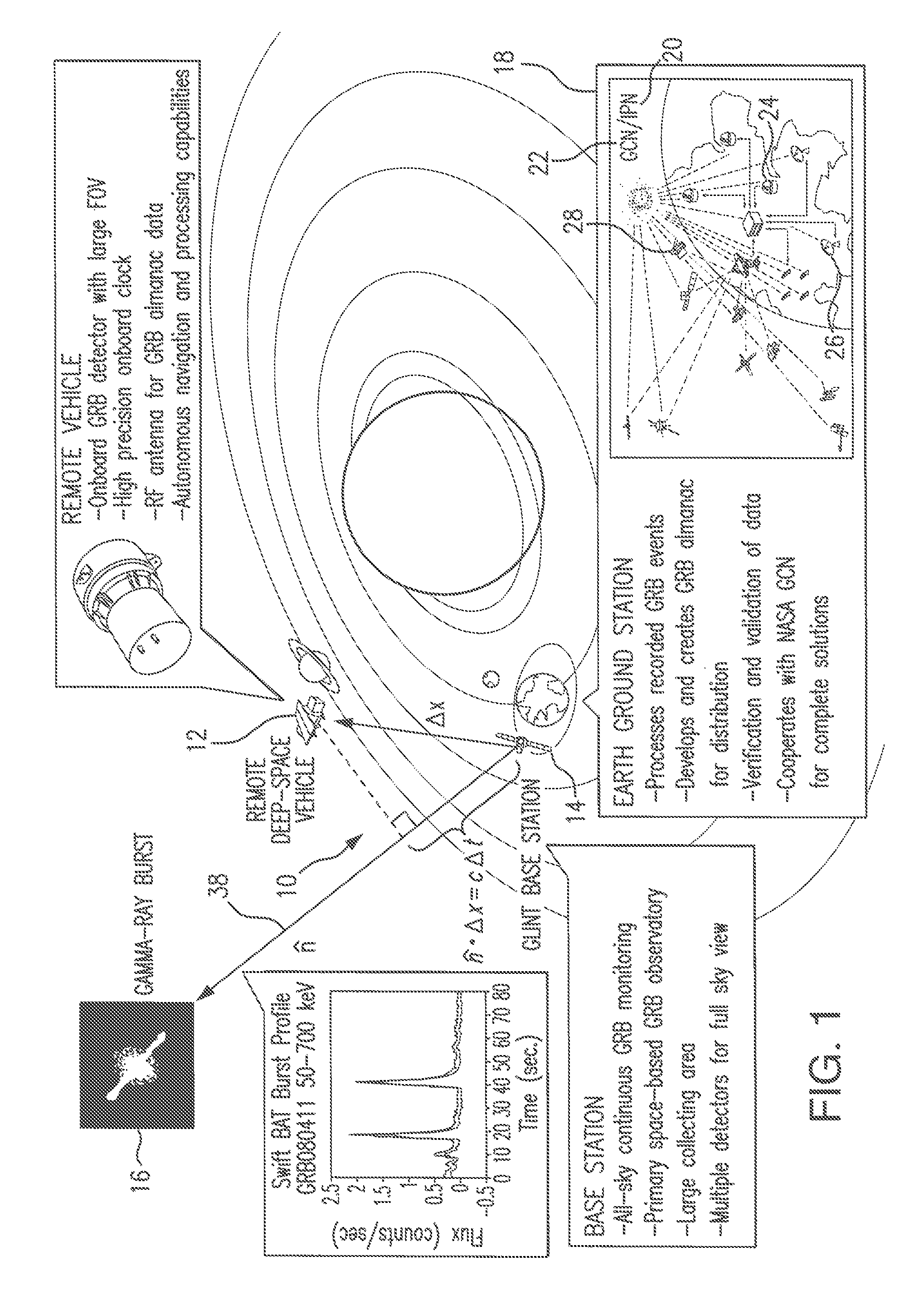
[0116]Referring to FIG. 1, representing the overall GLINT (Gamma-Ray Source Localization Induced Navigation and Timing) concept in an architecture for spacecraft navigation, the GLINT system 10 includes a high-resolution binning gamma ray detector sub-system for detection of gamma-ray photons from distant celestial gamma-ray bursts (GRBs) mounted on a vehicle (spacecraft) of interest 12, also intermittently referred to herein as a remote deep space vehicle (or spacecraft). The GLINT system also includes processor sub-system, mounted either on the spacecraft 12 of interest for an autonomous operation, or may reside and operate at a central control station, or alternatively may be distributed among participating stations in the overall GLINT architecture for the spacecraft 12 navigation.

[0117]Another high-resolution binning gamma-ray detector is mounted at a GLINT base station 14, also referred to herein as a reference (or observational) station orbiting the Earth. Both the remote spa...


PUM


Abstract

A method and system for spacecraft navigation using distant celestial gamma-ray bursts which offer detectable, bright, high-energy events that provide well-defined characteristics conducive to accurate time-alignment among spatially separated spacecraft. Utilizing assemblages of photons from distant gamma-ray bursts, relative range between two spacecraft can be accurately computed along the direction to each burst's source based upon the difference in arrival time of the burst emission at each spacecraft's location. Correlation methods used to time-align the high-energy burst profiles are provided. The spacecraft navigation may be carried out autonomously or in a central control mode of operation.

Description

STATEMENT REGARDING FEDERALLY SPONSORED RESEARCH OR DEVELOPMENT[0001]The development of the invention described herein was funded by NASA under Grant No. NNX12CE15P. The U.S. government has certain rights in this invention.REFERENCE TO THE RELATED APPLICATION[0002]This Utility Patent Application is based on Provisional Patent Application Ser. No. 61 / 764,472 filed on 13 Feb. 2013 and Ser. No. 61 / 783,321 filed on 14 Mar. 2013.FIELD OF THE INVENTION[0003]The present invention relates to a system and method for navigation of vehicles utilizing celestial sources of radiation.[0004]In particular, the present invention directs itself to continual estimation of three-dimensional spacecraft position and velocity using celestial gamma-ray sources; and specifically, to an autonomous or centralized navigation of a spacecraft using celestial gamma-ray sources.[0005]The present invention is also directed to a method and system using a gamma-ray detector mounted on a spacecraft, satellite, planeta...

Claims


Application Information

Patent Timeline
Patent Type & Authority Patents(United States)
IPC IPC(8): G01C21/02
CPCG01C21/025G01C21/02G01S5/166
Inventor SHEIKH, SUNEEL I.HISAMOTO, CHUCKARZOUMANIAN, ZAVEN
Owner ASTER LABS
Why Eureka
Try Eureka