Selection of a subset of global navigation satellite system measurements based on relation between shifts in target parameters and sum of residuals

a global navigation satellite and subset technology, applied in the field of global navigation satellite systems, can solve the problems of increasing the computational power of the receiver, increasing the computational increasing the computational so as to achieve the effect of increasing the computational power of the receiver, increasing the computational power, and increasing the computational power

Active Publication Date: 2016-03-15
TOPCON POSITIONING SYST INC
View PDF9 Cites 8 Cited by
  • Summary
  • Abstract
  • Description
  • Claims
  • Application Information

AI Technical Summary

Problems solved by technology

As the capability to track more signals increases, however, the required computational power of the receiver increases.
In general, increased computational power requires more complex hardware, higher power consumption, and higher cost.
Measurements from low-elevation satellites are subject to multipath reflection, refraction, and attenuation arising from various signal obstacles and obstructions.
Approaches based on analysis of SNR, signal power, and elevation angle values have the advantage of requiring relatively low computer resources; however, they do not provide optimum accuracy of the PVT solution.
The main drawback of the classical approach is that substantial computational resources are required to compute DOP values for different combinations of measurements.
This number of combinations is too computationally intensive in practice; especially, if the selection is repeated once per epoch (for example, once per second).
Since a DOP algorithm is still used as part of the overall method, however, the overall method still presents a substantial computational load.
These approaches require fewer computational resources, but they are not reliable.
Numerous algorithms have been developed based on this approach; however, they are limited to selecting four satellites.

Method used


Image

  • Selection of a subset of global navigation satellite system measurements based on relation between shifts in target parameters and sum of residuals
  • Selection of a subset of global navigation satellite system measurements based on relation between shifts in target parameters and sum of residuals
  • Selection of a subset of global navigation satellite system measurements based on relation between shifts in target parameters and sum of residuals

Examples


Embodiment Construction

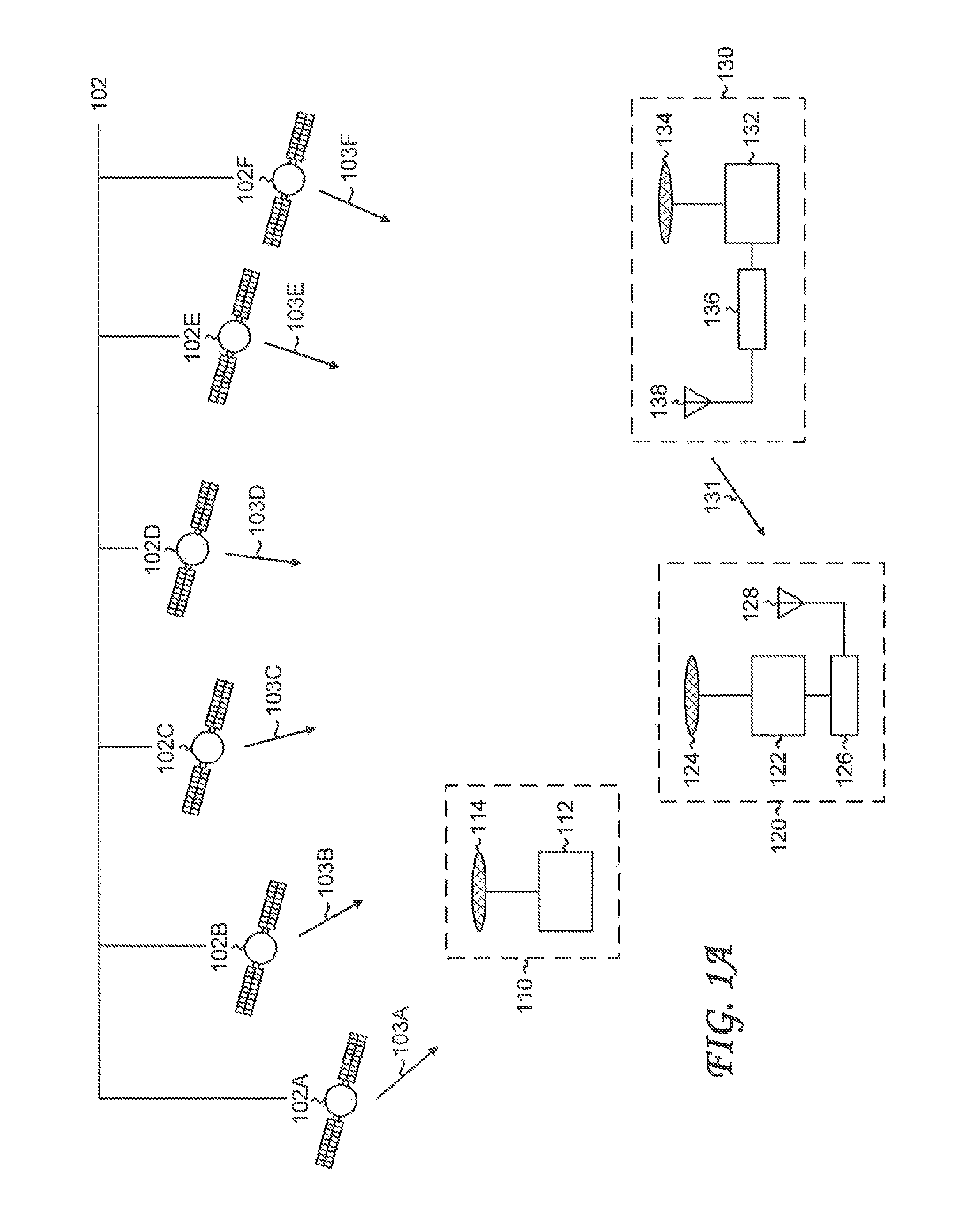
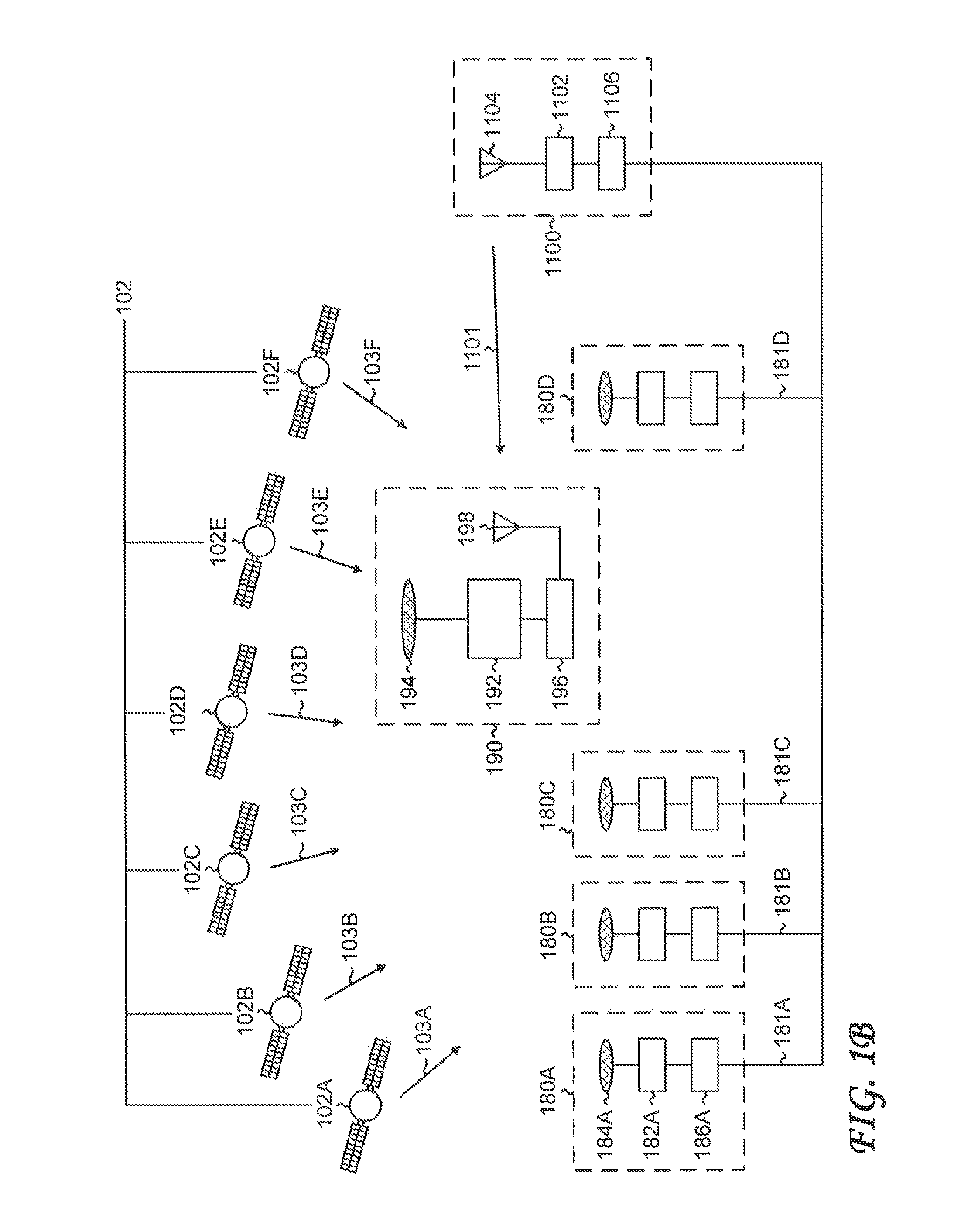
[0061]Global navigation satellite systems (GNSSs) can operate in various operational modes. Different operational modes require equipment of different complexities and can determine target parameters (such as position, velocity, and time) with different accuracies. The types and quantities of data to be processed also depend on the operational mode. Several operational modes are summarized below.

[0062]FIG. 1A shows a high-level schematic of a global navigation satellite system (GNSS). A constellation of global navigation satellites 102 transmits navigation signals. Shown are six representative navigation satellites, denoted navigation satellite 102A-navigation satellite 102F, which transmit navigation signal 103A-navigation signal 103F, respectively. In general, the navigation satellites can belong to more than one global navigation satellite system (for example, GPS and GLONASS).

[0063]Refer to the GNSS measurement unit 110, which operates in a stand-alone mode. The GNSS measurement...


PUM


Abstract

An optimum measurement subset with a specified number of elements is generated from a set of input global navigation satellite system (GNSS) measurements. A design matrix and a weight matrix are generated. Values of a set of coefficients corresponding to the set of input GNSS measurements are calculated. The value of a specific coefficient is calculated as the ratio of the change in value of the at least one target parameter resulting from the change in value of the specific input GNSS measurement to the change in value of the sum of squared residuals resulting from the change in value of the specific input GNSS measurement. The optimum measurement subset is selected based at least in part on the values of the set of coefficients.

Description

CROSS-REFERENCE TO RELATED APPLICATIONS[0001]This application claims the benefit of U.S. Provisional Application No. 61 / 661,891 filed Jun. 20, 2012, which is incorporated herein by reference in its entirety. This application is related to U.S. patent application Ser. No. 13 / 920,427 filed Jun. 18, 2013 (now U.S. Pat. No. 9,244,172), which is being filed concurrently herewith and which is herein incorporated by reference in its entirety.BACKGROUND OF THE INVENTION[0002]The present invention relates generally to global navigation satellite systems, and more particularly to selection of a subset of global navigation satellite system measurements.[0003]Global navigation satellite systems (GNSSs) enable determination of target parameters, such as position, velocity, and time (PVT) for users equipped with receivers of GNSS signals. Currently deployed global navigation satellite systems are the United States Global Positioning System (GPS) and the Russian GLONASS. Other global navigation sa...

Claims


Application Information

Patent Timeline
Patent Type & Authority Patents(United States)
IPC IPC(8): G01S19/42G01S19/28
CPCG01S19/28G01S19/42
Inventor O'CONNOR, RAYMOND M.DI FEDERICO, IVAN GIOVANNIAVERIN, SERGEYMILYUTIN, DANIEL
Owner TOPCON POSITIONING SYST INC
Why Eureka
Try Eureka