Apparatus and method for providing environmental predictive indicators to emergency response managers

a technology of environmental prediction and indicators, applied in the field of apparatus and methods for providing environmental predictive indicators to emergency response managers, can solve problems such as high probability of danger and/or service outage periods

Active Publication Date: 2016-03-15
SAINT LOUIS UNIVERSITY
View PDF45 Cites 26 Cited by
  • Summary
  • Abstract
  • Description
  • Claims
  • Application Information

AI Technical Summary

Benefits of technology

[0013]The present invention generally relates to systems and methods for providing decision support predictive indicators that will create real-time, detailed geographical distributions of the probability of the impact of weather events. The system and method can provide detailed geographical distributions of the probability of the impact of weather events on infrastructure, natural resources and / or environmental conditions and more particularly to the impact of storm damage due to severe weather events (including, high winds, icing, and lightning strikes) to infrastructure, for example the utility industry infrastructure, or other infrastructure. The present invention also relates to systems and methods for prediction and assessment of air-borne pollen, agricultural pathogens, and hazardous materials for a variety of public and private agencies. The system and method can also provide prediction and assessment information that make alter individualized decision. It could be as simple as whether or not to take an umbrella.
[0014]One or more of the embodiments of the present invention provide for a system and method for correlating localized weather predictions with relatively static infrastructure data. In a preferred embodiment, a network of monitoring stations input weather data into the Earth and Atmospheric Science (EAS) system. The network of monitoring stations can generally be referred to as a local Mesonet. These monitoring stations are spaced closer together than the 100-200 mile spacing of current monitoring stations, and are adapted to capture weather data more often than current monitoring stations, allowing for finer resolution of weather data. The monitoring stations or sensor suites can be remotely located and stand-alone systems with wireless transmission capability. The monitoring stations of the local Mesonet can also strategically placed based on certain parameters to optimize the efficacy of the stations and their respective data. The weather prediction system then utilizes this higher resolution weather data to predict the future weather conditions for an area, including future near-ground level weather. The processed data from the Mesonet is combined with weather prediction Mesoscale meteorological models operating on National Weather Service Data to predict the short-term weather at the neighborhood scale. Given a high spatial and temporal resolution meteorological forecast is made, the system combines the weather predictions with infrastructure data and / or natural environment data of the area to create a threat level index and a graphical map presentation of any threats. As will be understood by one skilled in the art, certain weather conditions combined with certain types of infrastructure can create emergency conditions. The threat level index is a probabilistic tool that rates areas in which certain infrastructure is likely to encounter certain, possibly hazardous conditions, and / or outages, which can result in a high probability of danger and / or service outage periods.
[0015]One embodiment of the present invention is to leverage on a Supervisory Control and Data Acquisition (SCADA) system of an electrical utility company. Many large electrical utility companies utilize a SCADA system to monitor and relay information related line status and other infrastructure status. The SCADA system utilized by electrical utilities usually utilize a series of substations that are distributed throughout the electrical utilities line and infrastructure system. The substations receive communications from various monitoring devices that are actively monitoring line status and the status of the other infrastructure. The substations receive the information transmitted to it wirelessly or by hardwire from the various monitoring devices. The substation can package the data received and transmit the status to a central server via an ethernet connection or other wide area network connection. The central server can process the information as well as transmit the information to other systems. This SCADA system can utilize the power lines to transmit data information or other means. In one embodiment of the present invention the SCADA system utilized by an electrical utility can be leveraged to transmit data from remote weather monitoring stations from any location were there are existing power lines. Utilizing SCADA will provide a comprehensive widespread network at low cost. The SCADA system can be equipped with electronic conversion devices that can wirelessly or via hardwire receive data transmission from remote weather monitoring stations and convert the data readings to a format and protocol that the SCADA system can handle and transmit. This embodiment is using the SCADA network available on the electrical power system in a way that was not intended but is quite effective in leveraging the SCADA electrical utility infrastructure to create a Local Mesonet network of weather monitoring stations that is comprehensive providing a high degree of spatial and temporal resolution that would be much more difficult and less cost effective to achieve without SCADA.

Problems solved by technology

The threat level index is a probabilistic tool that rates areas in which certain infrastructure is likely to encounter certain, possibly hazardous conditions, and / or outages, which can result in a high probability of danger and / or service outage periods.

Method used


Image

  • Apparatus and method for providing environmental predictive indicators to emergency response managers
  • Apparatus and method for providing environmental predictive indicators to emergency response managers
  • Apparatus and method for providing environmental predictive indicators to emergency response managers

Examples


Embodiment Construction

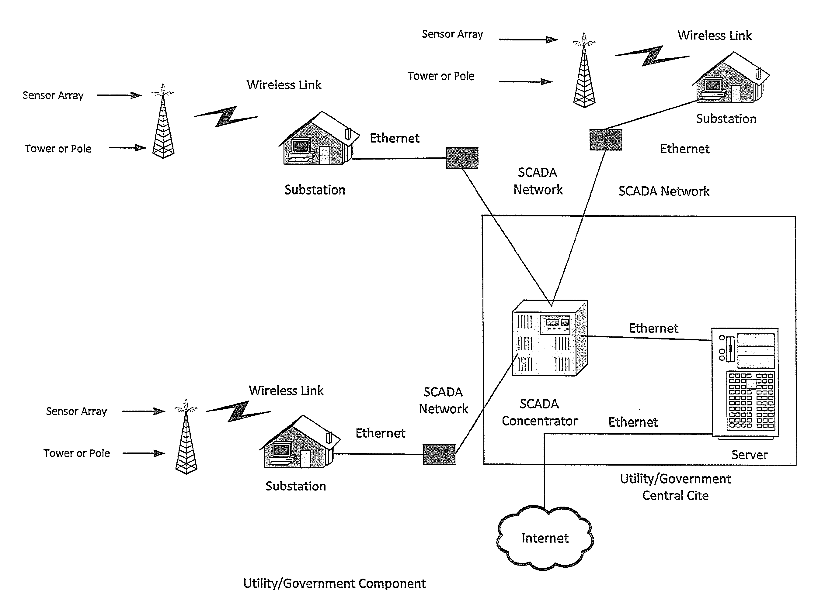
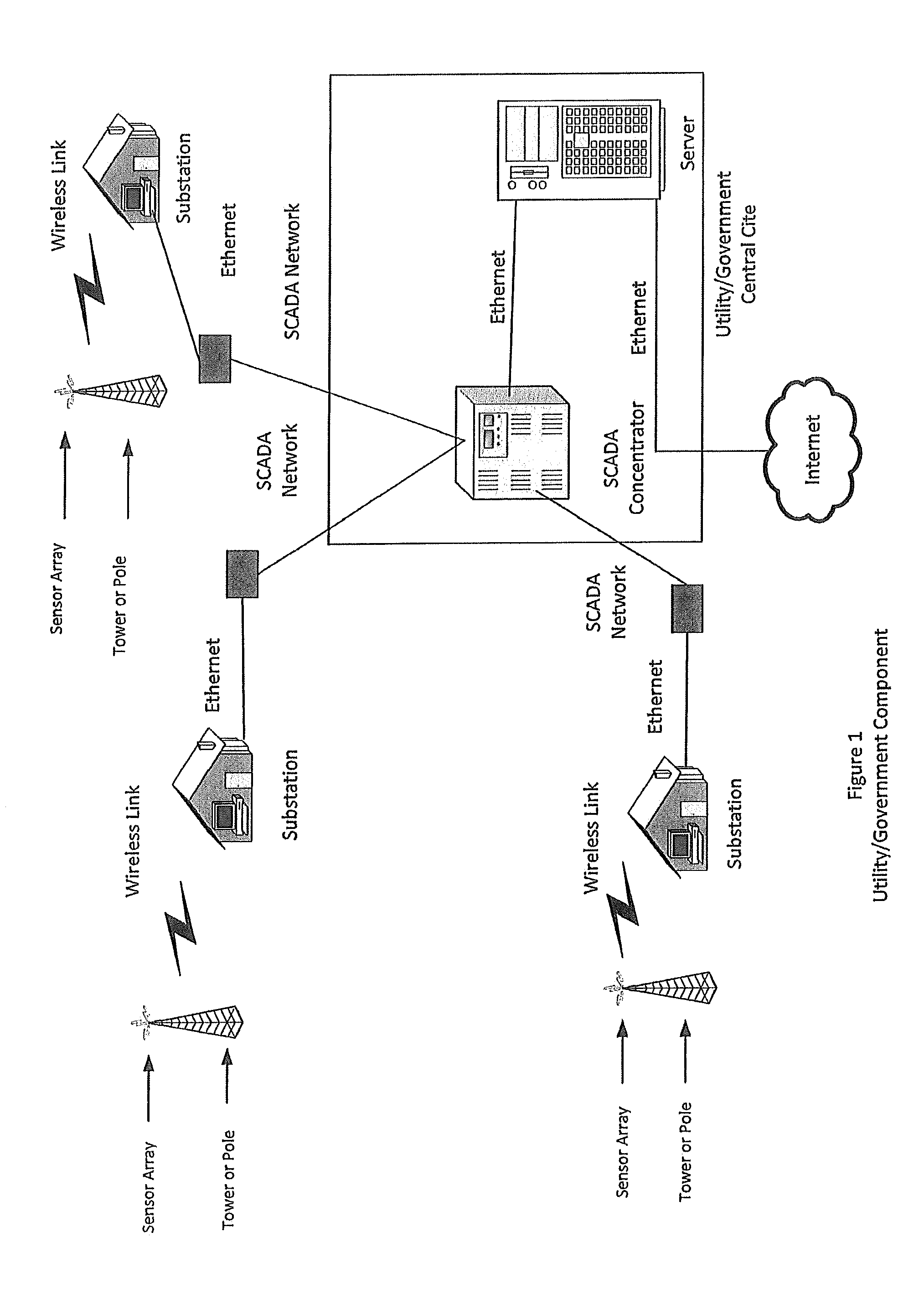
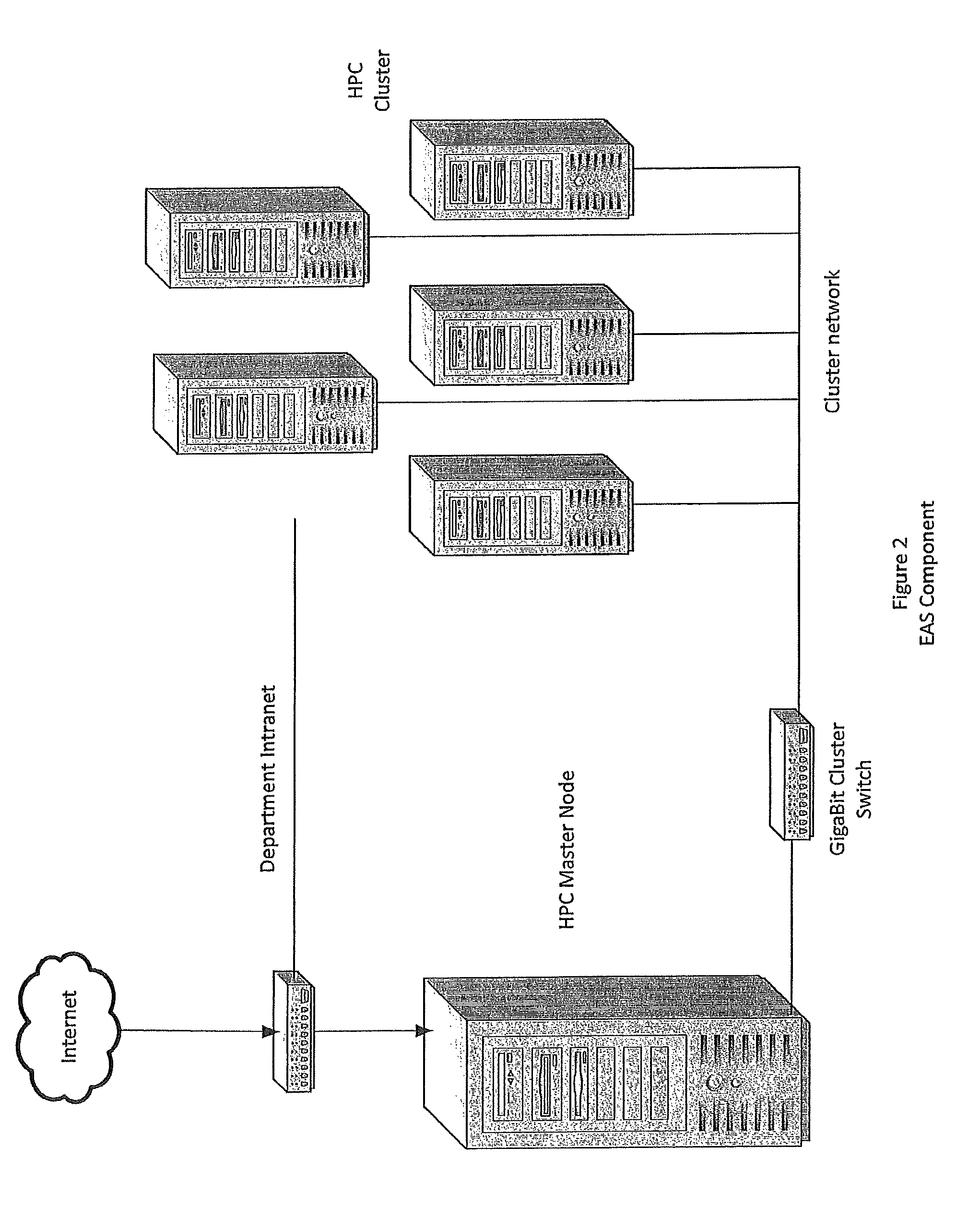
[0057]According to the embodiment(s) of the present invention, various views are illustrated in FIGS. 1-10 and like reference numerals are being used consistently throughout to refer to like and corresponding parts of the invention for all of the various views and figures of the drawing.

[0058]Data from all over the entire globe is typically utilized in order to make a forecast. Meteorological forecasting is performed in a global fashion. Global forecast data is available to forecasters around the world. There is a very large global model referred to as GFS, which stands for the Global Forecast System. Unfortunately, it is difficult to make that model work on a localized level in order to predict weather events accurately because the resolution of the model is very coarse—lacks sufficient resolution. Further, such a forecast system lacks the ability to factor in local parameters that may affect the accuracy of a prediction and further predict the impact that the weather event may cau...


PUM


Abstract

A method of predicting weather-exacerbated threats, said method comprising inputting localized weather measurement data into a weather threat prediction system; predicting future localized weather conditions based on said localized weather measurement data combined with modeling from large scale weather data including National Weather Service Data; inputting natural environment and infrastructure data into said weather threat prediction system; correlating said infrastructure data with said predicted future localized weather conditions; and determining a threat level index over a region, a threat level indicating an area having a certain probabilistic likelihood of being harmed by said future weather conditions.

Description

CROSS-REFERENCE TO RELATED APPLICATION[0001]This application is a continuation-in-part application of U.S. Non-Provisional Divisional application Ser. No. 13 / 483,208, filed May 30, 2012, entitled APPARATUS AND METHOD FOR PROVIDING ENVIRONMENTAL PREDICTIVE INDICATORS TO EMERGENCY RESPONSE MANAGER, which is a divisional application of U.S. Non-Provisional application Ser. No. 12 / 618,012, filed Nov. 13, 2009, entitled APPARATUS AND METHOD FOR PROVIDING ENVIRONMENTAL PREDICTIVE INDICATORS TO EMERGENCY RESPONSE MANAGER, which claims the benefit of and priority to U.S. Provisional Patent Application Ser. No. 61 / 114,357, filed Nov. 13, 2008, entitled SYSTEM AND METHOD FOR PROVIDING ENVIRONMENTAL PREDICTIVE INDICATORS TO EMERGENCY RESPONSE MANAGERS, which aforesaid applications are hereby incorporated by reference in their entirety to the extent permitted by law.BACKGROUND OF INVENTION[0002]1. Field of Invention[0003]The present invention generally relates to systems and methods for providi...

Claims


Application Information

Patent Timeline
Patent Type & Authority Patents(United States)
IPC IPC(8): G01W1/00G08B21/10G01W1/10G06F11/00
CPCG01W1/10G01W1/00G08B21/10
Inventor DANNEVIK, WILLIAMPASKEN, ROBERT W.
Owner SAINT LOUIS UNIVERSITY
Why Eureka
Try Eureka