Motes for environment mapping

a technology of environment mapping and motes, applied in the field of motes, can solve the problems of difficult access, hardware limitation, and inability to use state of art remote controlled exploration technologies, and achieve the effects of reducing or minimizing the overall required hardware components, simplifying the overall determination of spatial configuration, and reducing or minimizing the dimensions of the first motes

Active Publication Date: 2016-07-19
INGU SOLUTIONS INC
View PDF7 Cites 0 Cited by
  • Summary
  • Abstract
  • Description
  • Claims
  • Application Information

AI Technical Summary

Benefits of technology

[0008]The inventors have realized that the identification of individual motes in a system of motes may be possible by the frequency at which the individual motes emit their signal pulses. When mapping an unknown environment, for example, because it is difficult to access and / or where state of art remote controlled exploration technologies cannot be used. The localization of motes relative to each other may be used for mapping such environment. In the current description, a distinction is made between first motes which include a receiver and second motes which emit signal pulses at signal pulses at one of the frequencies in a predefined frequency band. Still, this invention also covers the situation in which all first motes and all second motes both transmit a signal pulse at a specific frequency within the predefined frequency band, and also receive the signal pulses from neighboring motes at a frequency within the predefined frequency band. By storing both the time delay between the emission of the signal pulse by the second mote (for example, a neighboring mote) at a specific frequency and the receiving of that same signal pulse by the first mote, a distance between the first mote and second mote can be determined. When also storing the frequency at which the received signal pulse was transmitted, the neighboring second mote can be identified compared to other neighboring second motes. The frequency may, for example, may be stored via a frequency label identifying the frequency within the predefined band of frequencies. From this data for a plurality of second motes, it is possible to determine which second motes surround the first mote and at which distance. Gathering this data over time also allows to determine a temporal change in the distribution of the second motes around the first mote. Combining this data for a plurality of first motes allows for determining the spatial configuration of the environment in which the system of first motes and second motes is located without external reference. Thus, localizing motes relative to each other within the environment allows for determining a geometrical structure or map of the environment.
[0022]In an embodiment of the system, the second motes are identical to the first motes. Separating the sensing of the signal pulses and the transmitting of the signal pulses amongst the first motes and the second motes, respectively, allows for the individual first motes and second motes to contain as few electrical components as possible. This enhances miniaturization or enables a maximum miniaturization of the motes and allows for the motes to consume as little power as possible, thus expanding the operational use of the motes to a maximum. Still, when all motes both transmit and receive the signal pulse, they all contribute to the overall mapping of the environment, which significantly simplifies the overall system and the overall reconstruction of the spatial configuration of the environment. This is achieved when the first motes and the second motes are identical.

Problems solved by technology

However, in some remote environments, such as, for example, oil wells or sewer systems in cities, the GPS signal does not reach the individual motes and other means of mapping the environment have to be found.
When mapping an unknown environment, for example, because it is difficult to access and / or where state of art remote controlled exploration technologies cannot be used.
In a preferred embodiment, all second motes emit the signal pulse at a unique frequency within the predefined frequency band, but this often is impractical due to the vast amount of motes required for detecting the spatially configuration of an environment.
For example, the transmitter may be hardware limited to only transmit the signal pulse at the first particular modulation frequency.
However, in some cases, the power of the motes may be been drained empty after having been inside the environment for a considerable amount of time.

Method used


Image

  • Motes for environment mapping
  • Motes for environment mapping
  • Motes for environment mapping

Examples


Embodiment Construction

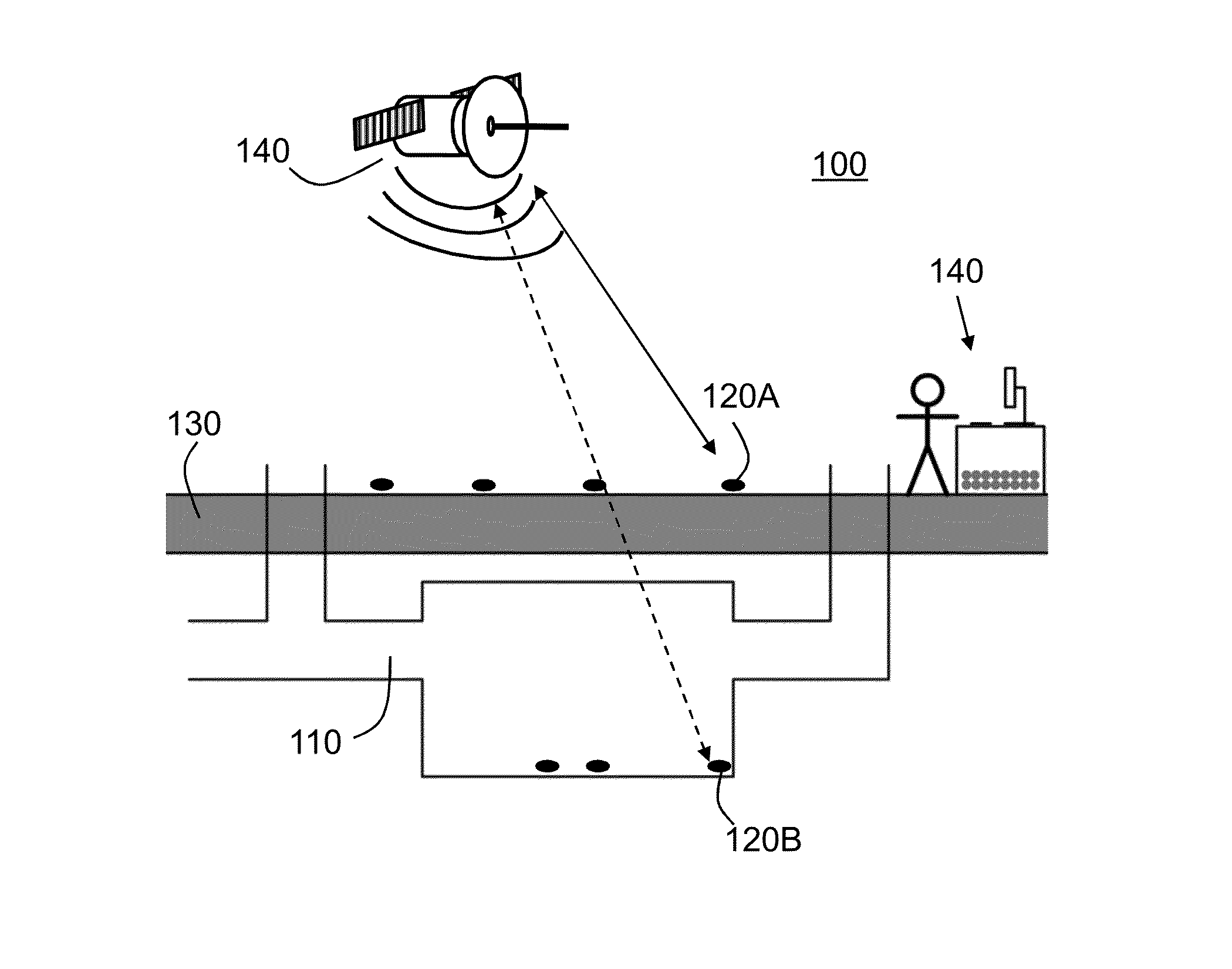
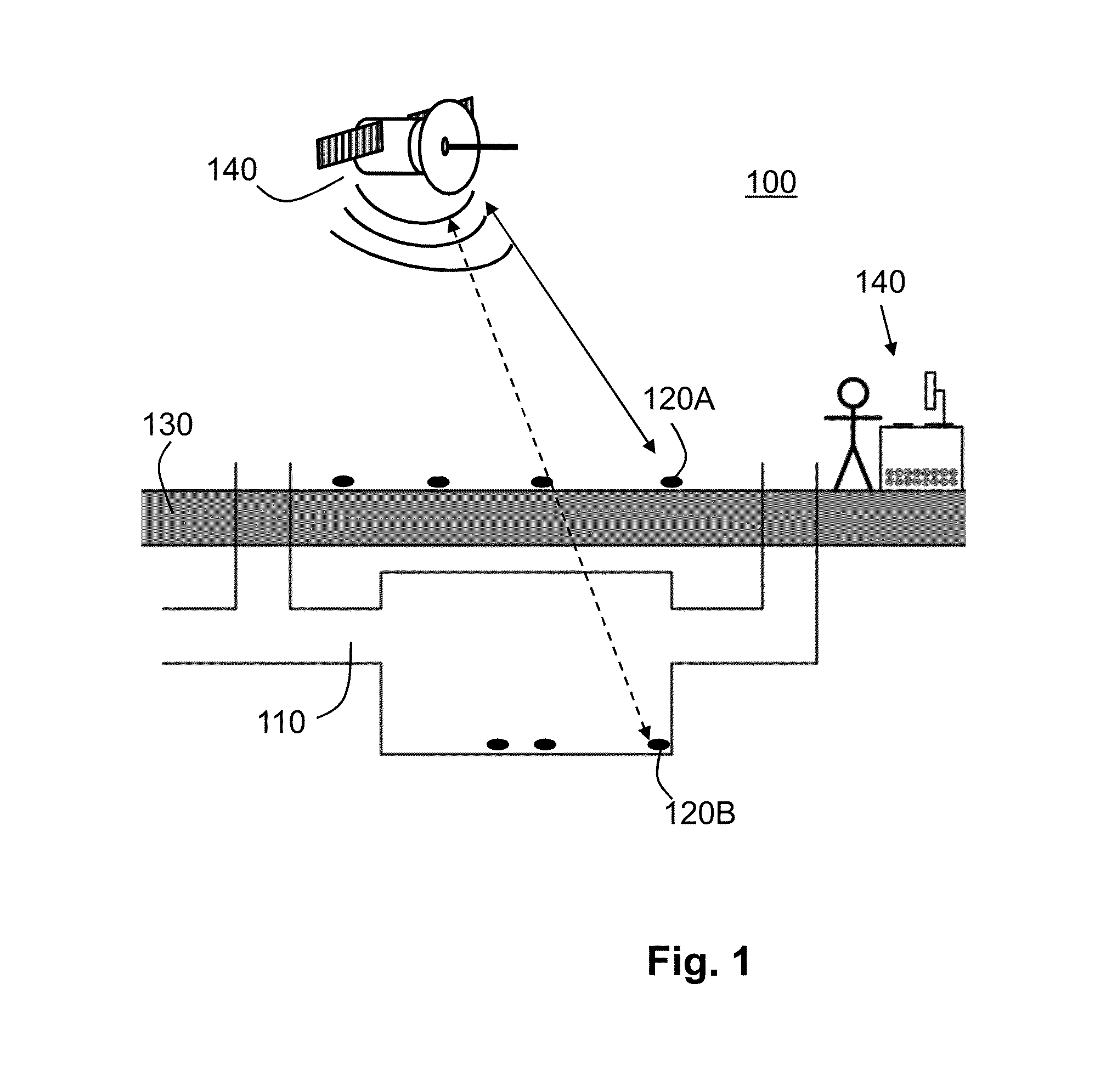
[0032]FIG. 1 shows an environment 100 in which a mapping is required. As indicated before, in known systems, the mapping of an environment may be done using a plurality of known sensor 120, also indicated as known motes 120A. The known motes 120A are distributed in the environment and communicate, for example, with a satellite 140 (indicated with a double arrow) to determine their position. This communication may also be used to exchange additional information which may be collected by the known motes 120A, such as local temperature, pressure, vibrations, etc. This information may be transferred to the base station 140—for example, again using the satellite 140 to collect all information and to interpret the received data to extract the required mapping. Alternatively, the network of known motes 120A may exchange the individual information of each of the known motes 120A amongst the other known motes 120A, such that each of the other known motes 120A substantially contains all or a ...


PUM


Abstract

Some embodiments provide a first mote and a system of motes for detecting a spatially configuration without the need for an external reference. A first mote is configured for wirelessly receiving a plurality of signal pulses transmitted by a plurality of second motes, each second mote transmitting the signal pulse at one particular modulation frequency from a plurality of frequencies of a frequency band. The first mote includes a receiver for determining from a received signal at least one of the plurality of signal pulses and for identifying the particular modulation frequency of the at least one signal pulse. The first mote further includes a clock for generating a time-stamp at which the signal pulse is received and a storage unit for storing the time-stamp and the corresponding identified particular modulation frequency. The system includes a plurality of first motes and second motes.

Description

FIELD[0001]Some embodiments relate to a first mote for mapping an unknown environment, as well as to a mapping system.BACKGROUND ART[0002]A mote is a node in a wireless network and often refers back to a relatively small sensor with energy storage. They have been used in many diverse applications, from earthquake measurements to warfare.[0003]Such related art motes typically include a controller, transceiver, power source and one or more sensors. One example of environmental monitoring can be found in the NASA sensor web. This network includes spatially distributed sensors that wirelessly communicate with each other. In this network, every mote sends out collected data to every other mote, so substantially every mote knows what is happening in the network.[0004]The position of the individual motes should typically be known when using such related art networks for environmental mapping. This is typically done using GPS systems to provide information on each one of the individual mote...

Claims


Application Information

Patent Timeline
Patent Type & Authority Patents(United States)
IPC IPC(8): H04M7/00H04L29/08H04L27/10H04B7/04H04W84/18
CPCH04B7/04H04L27/10H04L67/12H04W84/18
Inventor TALNISHNIKH, ELENADUISTERWINKEL, HENDRIK ALBERTWORTCHE, HEINRICH JOHANNESVAN POL, JOHANNES HUBERTUS GERARDUS
Owner INGU SOLUTIONS INC
Why Eureka
Try Eureka