
GPS and pseudo-satellite combined positioning method

A combined positioning and pseudolite technology, applied in the field of GPS and pseudolite combined positioning, can solve the problems of reduced GPS positioning accuracy, reduced number of GPS satellites, and inability to navigate and position with GPS signals

Inactive Publication Date: 2008-02-27
HOHAI UNIV
View PDF1 Cites 0 Cited by
  • Summary
  • Abstract
  • Description
  • Claims
  • Application Information

AI Technical Summary

Problems solved by technology

When the number of visible GPS satellites tracked is small and the distribution of satellite geometry is not good, the positioning accuracy of GPS will be greatly reduced
For "urban canyons" in urban high-rise dense areas and reservoirs, power stations, and mining areas located in deep mountain canyons, the GPS receiver antenna is blocked, which reduces the number of GPS satellites received, resulting in reduced GPS positioning accuracy, which cannot meet navigation and positioning requirements
In addition, it is currently not possible to directly use GPS signals for navigation and positioning indoors, underground, tunnels and underwater
Therefore, a single GPS positioning system has flaws

Method used


Image

  • GPS and pseudo-satellite combined positioning method
  • GPS and pseudo-satellite combined positioning method
  • GPS and pseudo-satellite combined positioning method

Examples


Embodiment

[0090] 1. Set up the pseudolite position

[0091] This method uses a fast pseudolite optimal position search method, the algorithm is as follows:

[0092] (1) First place the pseudolite and the user at the same height, and use the simple HDOP criterion for azimuth scanning near the station. That is, the orientation OP when the HDOP is the minimum is the optimal placement orientation of the pseudolite on the horizontal plane.

[0093] Horizontal precision reduction factor: HDOP = q 11 + q 22 , q ii It is an element of the matrix Q.

[0094] (2) Then, on the OHP plane, carry out azimuth scanning on the vertical plane near the user. Since the orientation change on the vertical plane affects three components, the weighted DOP is used to judge. WDOP=(a×VDOP+b×HDOP) / (a+b), the constants a and b are selected according to the requireme...


PUM


Abstract

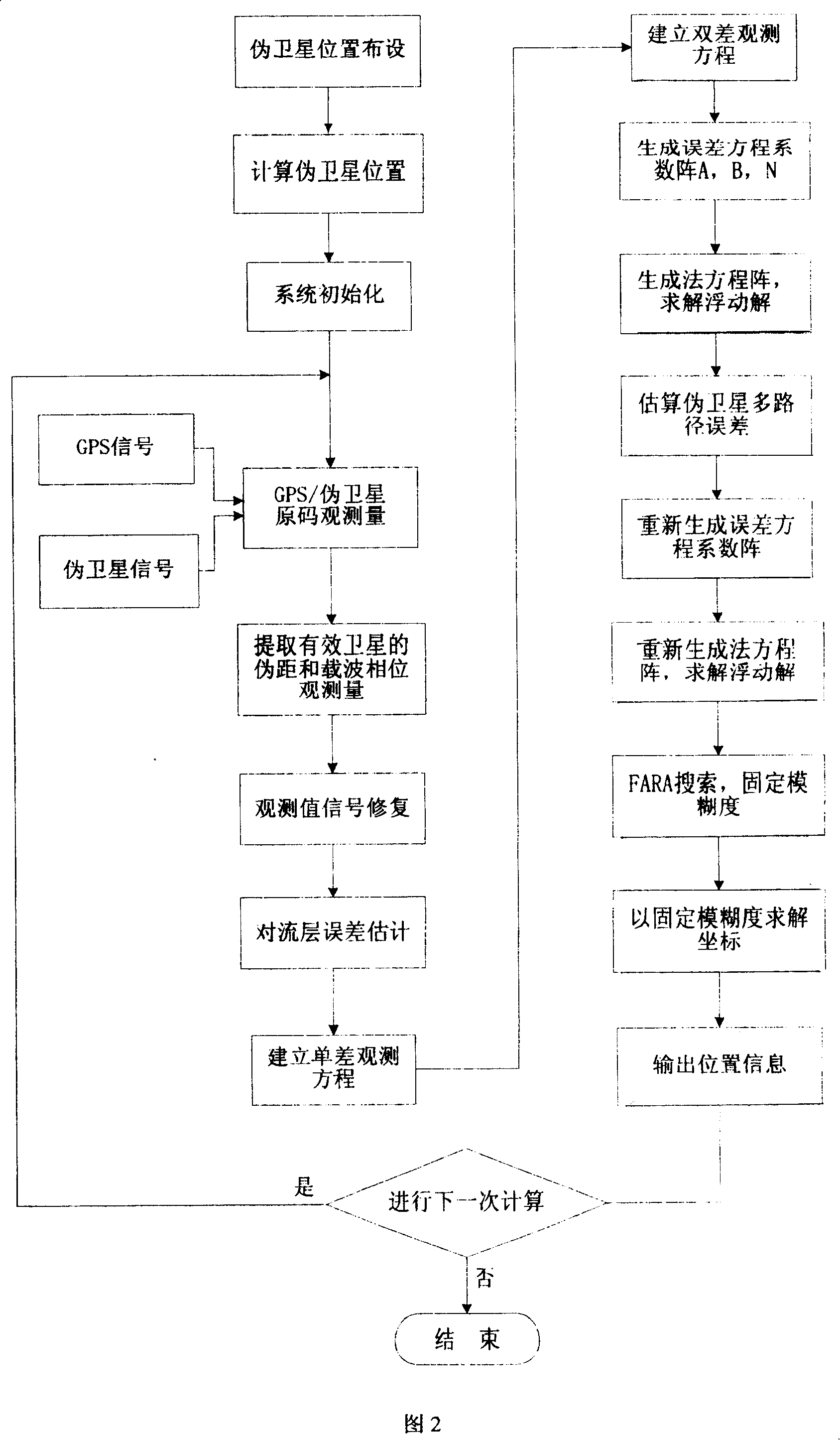
A positioning method includes fourteen steps as setting pseudosatellite position, collecting and recording signal from GPS and pseudosatellite, picking up pseudodistance and observation value of effective satellite, estimating tropospheric error, finding single and double difference, generating error equation coefficient A and B as well as normal equation, using FARA searching to fix fuzzy degree for finding coordinate, etc.

Description

1. Technical field [0001] The invention relates to a positioning method, in particular to a combined positioning method of GPS and pseudo-satellites, which is suitable for precise positioning of targets in urban environments, valley areas and mining areas. 2. Background technology [0002] Global Positioning System (GPS) has been widely used in the positioning of open-air targets and precision surveying engineering. However, GPS receivers receive satellite signals from an altitude of more than 20,000 kilometers. When the signals reach the ground, they are already very weak, so GPS signals are easily interfered. Furthermore, the positioning accuracy and reliability of GPS greatly depend on two factors, the number of visible GPS satellites and the spatial distribution of satellites. When the number of visible GPS satellites tracked is small and the distribution of satellite geometry is not good, the positioning accuracy of GPS will be greatly reduced. For "urban canyons" in ...

Claims


Application Information

Patent Timeline
Patent Type & Authority Patents(China)
IPC IPC(8): G01S5/02
Inventor 何秀凤杨光
Owner HOHAI UNIV
Learn More