Seismic exploration position calibration method based on prestack wave field simulation

A technology for seismic exploration and horizon calibration, applied in seismology and seismic signal processing for well logging records, can solve problems such as increasing oil and gas exploration risks, differences in synthetic seismic records, and differences, to achieve accurate geological meaning and Improvement of lithological characteristics and horizon calibration accuracy and the effect of improved accuracy

Inactive Publication Date: 2007-08-08
DAGANG OIL FIELD OF CNPC
View PDF0 Cites 69 Cited by
  • Summary
  • Abstract
  • Description
  • Claims
  • Application Information

AI Technical Summary

Problems solved by technology

[0026] First, the actual seismic records have gone through two processes of field acquisition and seismic data computer processing. The field acquisition method of seismic data and the computer processing flow of seismic data have a great influence on the reflection characteristics of actual seismic data. The method of synthesizing seismic records does not consider the impact of seismic data acquisition and processing, resulting in discrepancies between synthetic seismic records and actual seismic records
[0027] Second, the seismic records collected by field seismic exploration include not only primary reflections, but also multiple waves and converted waves. The influence of the seismic records will inevitably lead to discrepancies between the synthetic seismic records and the actual seismic records
[0028] The above defects reduce the consistency between the synthetic seismic records and the seismic traces of the actual seismic records, increase the difficulty of horizon calibration in seismic exploration, and reduce the quality of horizon calibration, especially for oil and gas reservoirs with weak reflections. It is difficult to correctly establish the corresponding relationship between seismic reflection and oil and gas reservoirs, which leads to errors or even mistakes in the interpretation and prediction of oil and gas reservoirs based on seismic data, and increases the risk of oil and gas exploration.

Method used


Image

  • Seismic exploration position calibration method based on prestack wave field simulation
  • Seismic exploration position calibration method based on prestack wave field simulation
  • Seismic exploration position calibration method based on prestack wave field simulation

Examples


Embodiment Construction

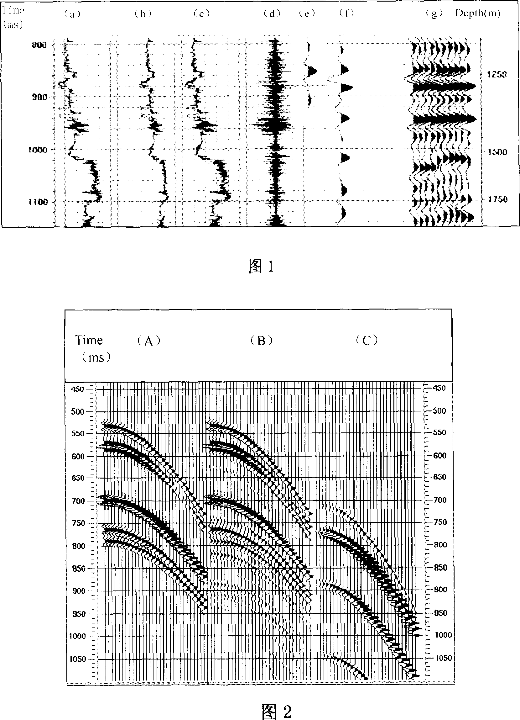
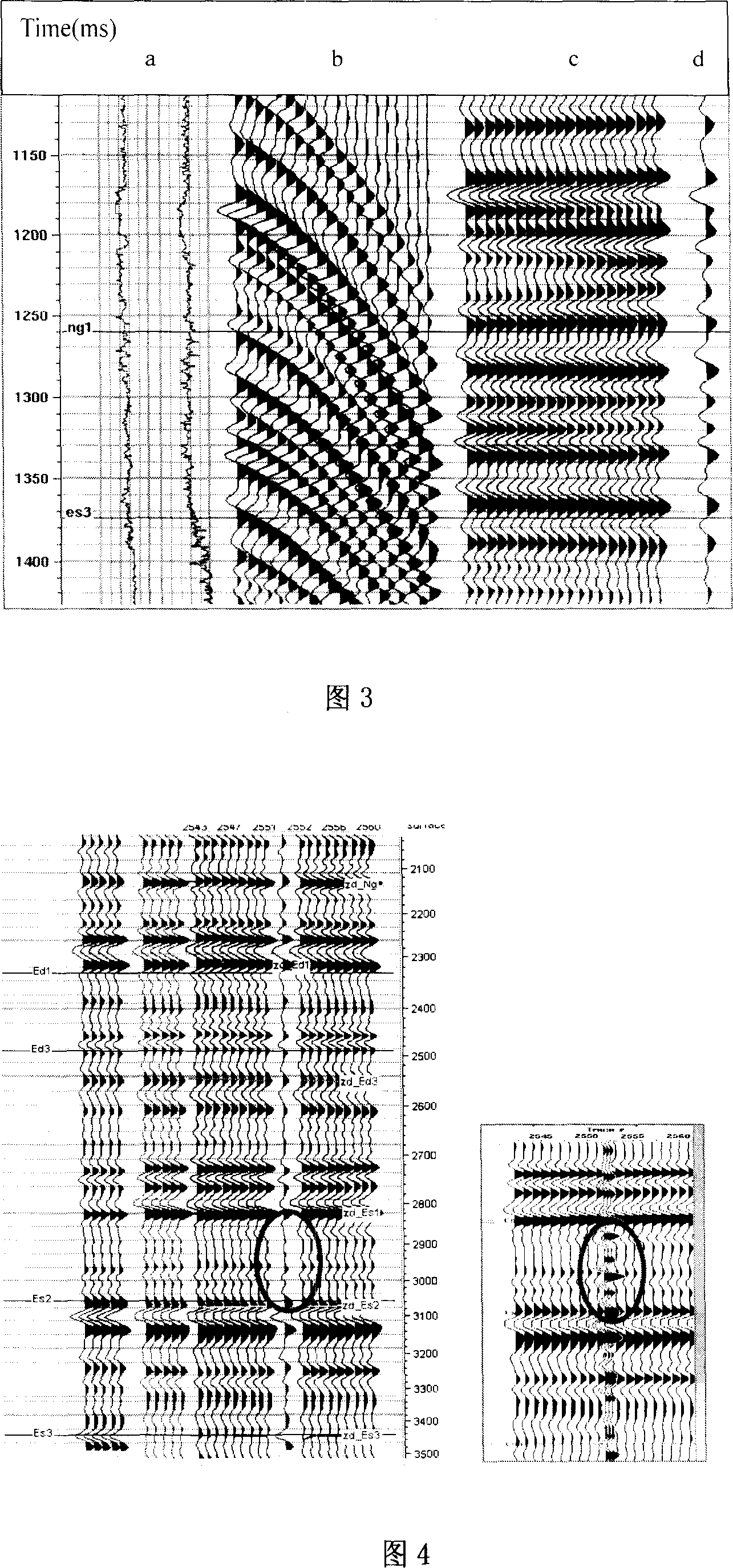
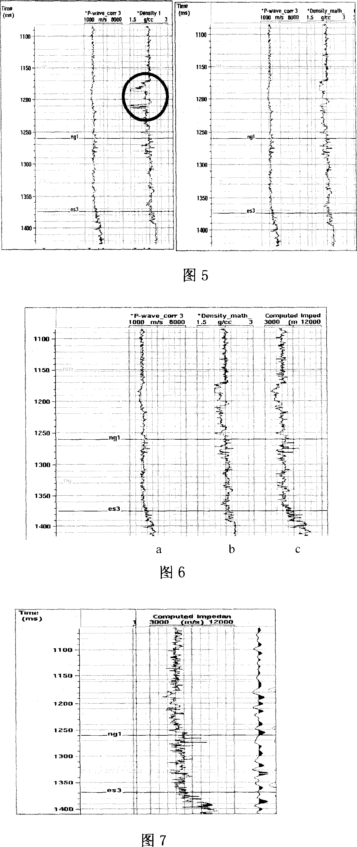
[0094] The method for calibrating seismic exploration horizons based on pre-stack wave field simulation of the present invention will be further described below in conjunction with the embodiments and accompanying drawings, and the steps and process of the present invention will be described by taking Well Zhanghai 8 as an example:

[0095] The first step is editing of density logging curve and acoustic logging curve;

[0096] As shown in Figure 5, the comparison of the well logging curves of Zhanghai 8 well before editing (on the left) and after editing (on the right), the parts marked by the circles on the left have obvious abnormal amplitude noise. The median filter with a length of 15 performs median filtering on the density curve. The right side of Fig. 5 is the result of the logging curve after median filtering. It can be seen that the amplitude of abnormal noise has been effectively suppressed.

[0097] The second step is to obtain the wave impedance curve from the dens...


PUM


Abstract

The invention relates to the earthquake exploration position calibration technology based on the pre-stack wave field simulation, belonging to the seismic data processing and interpretation technology field in oil exploration. The invention considers the seismic information acquisition and processing impact, considers multiple waves and conversion waves action in the reflection waves, enhances the accuracy of integrated seismic records, and enhances the consistency of integrated seismic records and real seismic records, this approach including the following eight steps: filtering and editing of density and acoustic logging well curve; using density and acoustic logging well curve to calculate the wave impedance curve; using statistics sub wave to integrate the seismic records; comparing the integrated seismic records and well-side seismic road, properly stretching the logging well curve; using well-side seismic road and logging well reflection coefficient curve to extract certainty sub wave; using the reflection rate method to simulate the pre-stack common reflection points roads set; simulating the real seismic data processing, and obtaining the final integrated seismic records; using the final integrated seismic records and comparing with the well-side seismic road, to process seismic exploration position calibration.

Description

technical field [0001] The invention relates to a seismic exploration layer calibration method based on pre-stack wave field simulation, and belongs to the technical field of processing and interpretation of seismic data in petroleum exploration. Background technique [0002] Seismic exploration is an exploration method that uses artificial seismic technology to detect underground structures. It excites seismic waves near the surface in a certain way. The seismic waves propagate from the source to the underground. After encountering the geological interface, reflections occur at the interface, and the reflected seismic waves propagate upward. A device that receives reflected waves from geological interfaces. [0003] Field seismic exploration collects reflected wave data on the geological interface of the exploration area at a certain ground grid position. Although the reflected wave data received in the field carry the information of the geological interface, these seismi...

Claims


Application Information

Patent Timeline
Patent Type & Authority Applications(China)
IPC IPC(8): G01V1/48G01V1/50G01V1/40G01V1/28
Inventor 廖前进李国发肖敦清袁淑琴卢义李红香李冰
Owner DAGANG OIL FIELD OF CNPC
Why Eureka
Try Eureka