Method for tracing navigation system and tracing navigation

A navigation system and navigation module technology, applied in the field of GPS navigation, to achieve the effect of reducing dependence and saving construction costs

Active Publication Date: 2008-03-05
SHENZHEN SEG SCI NAVIGATIONS CO LTD
View PDF0 Cites 18 Cited by
  • Summary
  • Abstract
  • Description
  • Claims
  • Application Information

AI Technical Summary

Problems solved by technology

And when another mobile terminal needs to know the location information of the aforementioned terminal to track it, it can only obtain its location information through the monitoring center

Method used


Image

  • Method for tracing navigation system and tracing navigation
  • Method for tracing navigation system and tracing navigation
  • Method for tracing navigation system and tracing navigation

Examples


Embodiment Construction

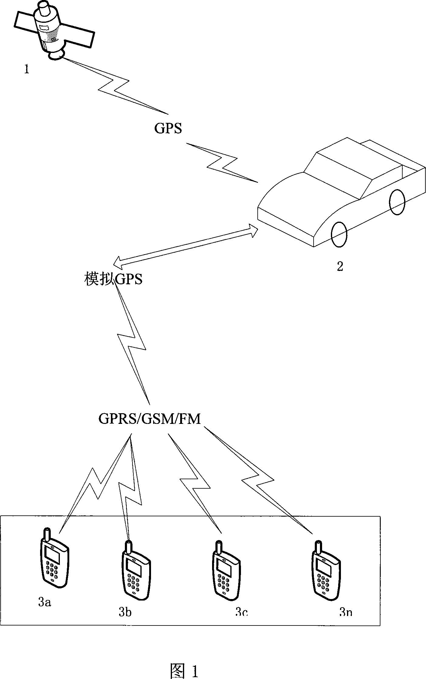
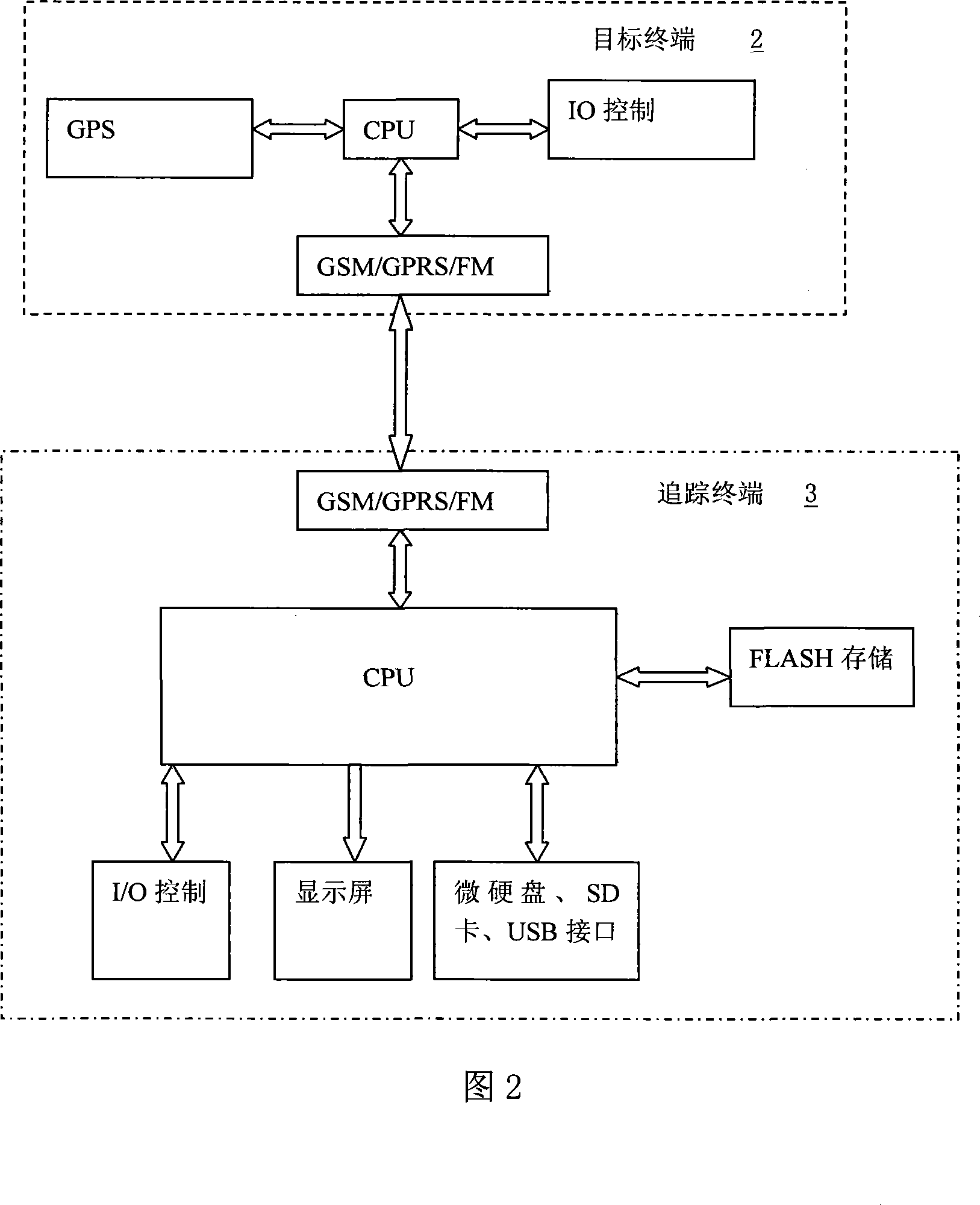
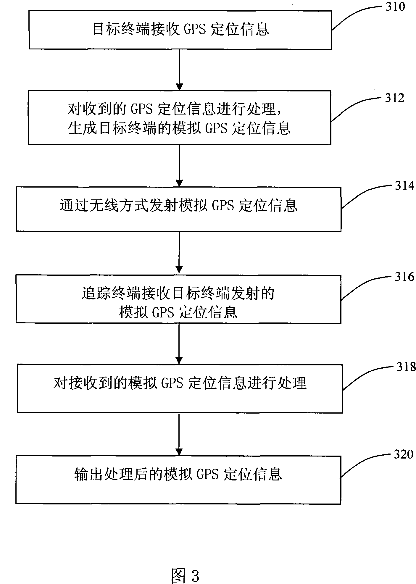
[0036] The present invention is based on the application of GPS positioning and navigation, GIS, mobile communication technologies (such as FM, GSM, GPRS and CDMA, etc.), on the basis of receiving GPS signal navigation sent by static satellites, through mobile communication functions, The received information of the dynamic target terminal is simulated as a tracking and navigation system of GPS signals of other mobile tracking terminals.

[0037] The present invention simulates dynamic GPS information such as latitude and longitude, altitude, direction, and speed of the target terminal as the GPS signal of the designated target by using the GPS rapid positioning information of the tracked dynamic target terminal and utilizing the wireless communication, short message, GPRS and other communication functions of the mobile communication , so that one or more receiving objects can implement tracking navigation through GIS processing through the received simulated dynamic target ter...


PUM


Abstract

The invention relates to a tracking navigation system and a tracking navigation method. The tracking navigation system comprises a target terminal and at least a tracking terminal. The target terminal comprises: a GPS receiving module and a first processor, which are used for receiving and processing a GPS positioning signal in order to generate an analog GPS positioning message of the target terminal; a first radio communication module. The tracing terminal comprises: a second radio communication module and a second processor, which are used for receiving and processing the analog GPS positioning signal; an output unit used for outputting said processed analog GPS positioning message. By applying the tracking navigation system and the tracking target terminal method, the mobile communication can be used for imitating the GPS signal of a dynamic target terminal as a another GPS satellite signal of dynamic tracking terminal, so as to reproduce or real-time tracking the movement of the target terminal according to the imitating GPS signal to realize the tracking navigation.

Description

technical field [0001] The invention relates to GPS navigation technology, more specifically, to a GPS-simulating tracking navigation system and a tracking navigation method thereof. Background technique [0002] Global Positioning System (GPS) is the acronym for Global Positioning System in English. It was developed by the United States in the 1970s and fully completed in 1994. It is a new generation of satellites with sea, land and air positioning capabilities and all-round real-time three-dimensional navigation. positioning and navigation system. The GPS system can be used not only for surveying and navigation, but also for speed measurement and timing. Through accurate positioning of satellite signals received by GPS, information such as the route, position, speed, and altitude of the simulated terminal being tracked can be known. [0003] Mobile communication is communication between moving objects, or communication between a moving object and a stationary object. Th...

Claims


Application Information

Patent Timeline
Patent Type & Authority Applications(China)
IPC IPC(8): G01S1/02G01S1/04G08C17/02G08C19/00H05K11/02G01S19/14G01S19/42
Inventor 刘云黄冠明
Owner SHENZHEN SEG SCI NAVIGATIONS CO LTD
Why Eureka
Try Eureka