Navigation device and describing method of cross point indication map
A technology of navigation device and intersection, applied in directions such as navigation, measurement device, surveying and navigation, etc., can solve the problems that users are difficult to grasp, cannot determine the exit, and cannot be identified by users.
- Summary
- Abstract
- Description
- Claims
- Application Information
AI Technical Summary
Problems solved by technology
Method used
Image

Examples
no. 1 Embodiment approach
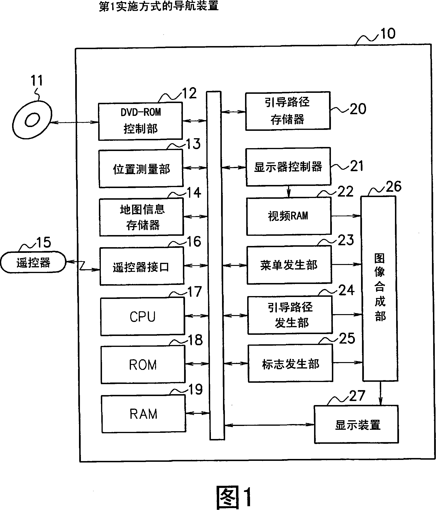
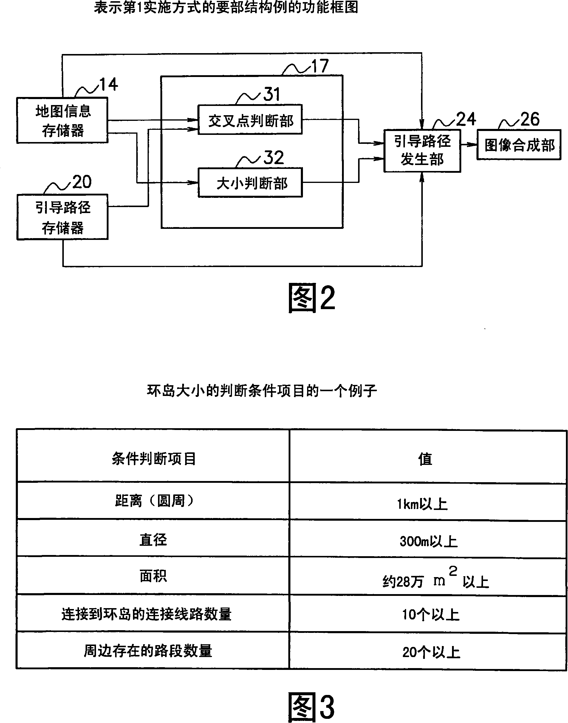
[0026] Hereinafter, a first embodiment of the present invention will be described with reference to the drawings. FIG. 1 is a block diagram showing a configuration example of a navigation device 10 according to the first embodiment. In FIG. 1 , 11 is a map recording medium such as a DVD-ROM, which stores various map data necessary for map display and route search. In addition, here, the DVD-ROM 11 is used as the recording medium storing the map data, but other recording media such as CD-ROM, hard disk, and semiconductor memory may also be used. 12 is a DVD-ROM control unit which controls reading of map data from the DVD-ROM 11 .
[0027] Here, the map data recorded on the DVD-ROM 11 will be described in detail. The map data recorded in the DVD-ROM 11 includes road data necessary for various processing such as map display and route search. Road data, including information about nodes corresponding to points where multiple roads intersect, such as intersections or fork roads;...
no. 2 Embodiment approach
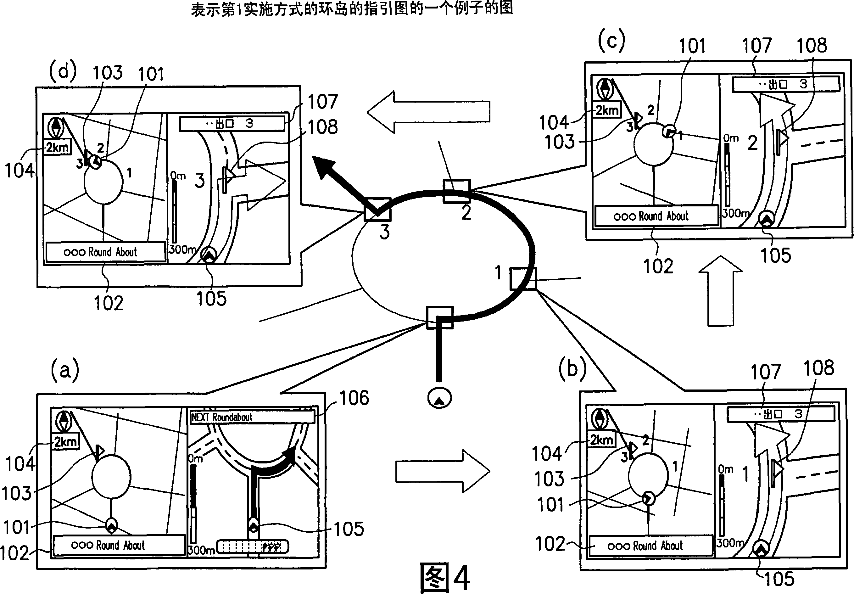
[0067] Next, a second embodiment of the present invention will be described based on the drawings. The configuration of the navigation device 10 according to the second embodiment is the same as the block diagram shown in FIG. 1 . In the second embodiment, the function of the guidance route generation unit 24 is different from that in the first embodiment. However, the configuration of the main parts is the same as that of the functional block diagram shown in FIG. 2 , and thus will be described using the same reference numerals.
[0068] The guidance route generation unit 24 (corresponding to the drawing unit of the present invention) of the second embodiment draws and represents the inside of the roundabout based on the map data read from the map information memory 14 and the guidance route data read from the guidance route memory 20. An itinerary guide for trips to various fork locations in place of a zoomed-in map. In addition, the guide route generating unit 24 may disp...
no. 3 Embodiment approach
[0075] Next, a third embodiment of the present invention will be described with reference to the drawings. FIG. 8 is a block diagram showing a configuration example of a navigation device 40 according to the third embodiment. As shown in FIG. 8 , the configuration of the navigation device 40 of the third embodiment includes an enlarged intersection image memory 28 (corresponding to the enlarged image data storage unit of the present invention) in addition to the configuration of the first embodiment. In addition, in the third embodiment, the function of the guidance route generating unit 41 (corresponding to the drawing unit of the present invention) is different from that in the first embodiment. FIG. 9 is a functional block diagram showing a configuration example of main parts of the third embodiment. In FIGS. 8 and 9 , components having the same functions as those shown in FIGS. 1 and 2 are assigned the same reference numerals.
[0076] In FIG. 8 , the enlarged intersecti...
PUM
 Abstract
Description
Claims
Application Information
 - R&D
- Intellectual Property
- Life Sciences
- Materials
- Tech Scout
- Unparalleled Data Quality
- Higher Quality Content
- 60% Fewer Hallucinations
Browse by: Latest US Patents, China's latest patents, Technical Efficacy Thesaurus, Application Domain, Technology Topic, Popular Technical Reports.
© 2025 PatSnap. All rights reserved.Legal|Privacy policy|Modern Slavery Act Transparency Statement|Sitemap|About US| Contact US: help@patsnap.com