Flood and field compatible satellite radar height-finding instrument tracker

A radar altimeter and tracker technology, used in height/level measurement, instruments, reflection/re-radiation of radio waves, etc., can solve the problem that radar altimeter trackers cannot be well compatible with ocean and land, and achieve tracking robustness Strong, high tracking accuracy, and the effect of improving tracking performance

Inactive Publication Date: 2008-05-14
CENT FOR SPACE SCI & APPLIED RES
View PDF0 Cites 6 Cited by
  • Summary
  • Abstract
  • Description
  • Claims
  • Application Information

AI Technical Summary

Problems solved by technology

[0006] The purpose of the present invention is to overcome the defect that the existing radar altimeter tracker cannot be well compatible with the ocean and land, thereby providing a system that can be used for both ocean and land measurements, and has high measurement accuracy and robustness. Strong radar altimeter tracker

Method used


Image

  • Flood and field compatible satellite radar height-finding instrument tracker
  • Flood and field compatible satellite radar height-finding instrument tracker
  • Flood and field compatible satellite radar height-finding instrument tracker

Examples


Embodiment Construction

[0022] The sea and land compatible satellite radar altimeter tracker of the present invention will be described below with reference to the accompanying drawings and specific embodiments.

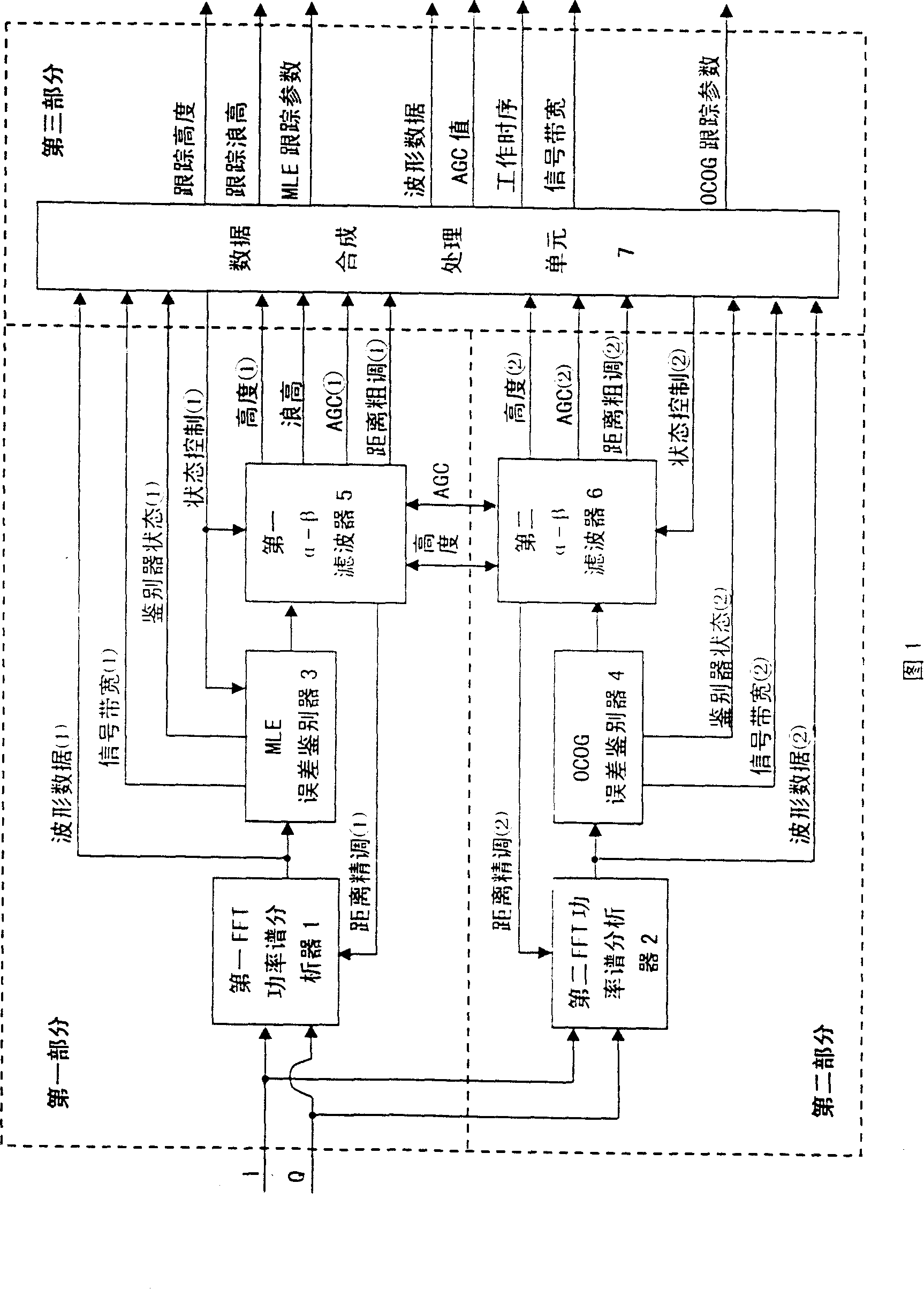
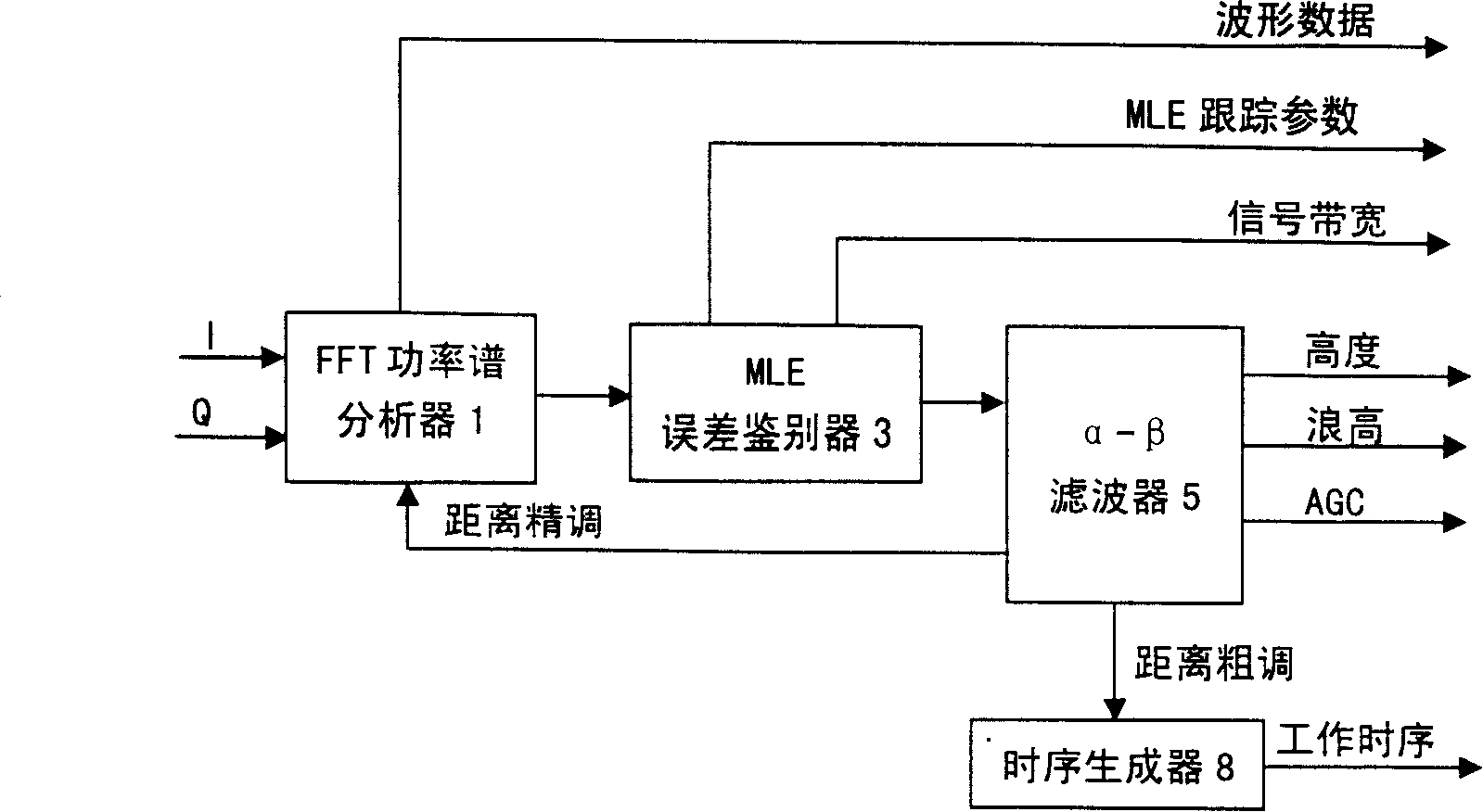
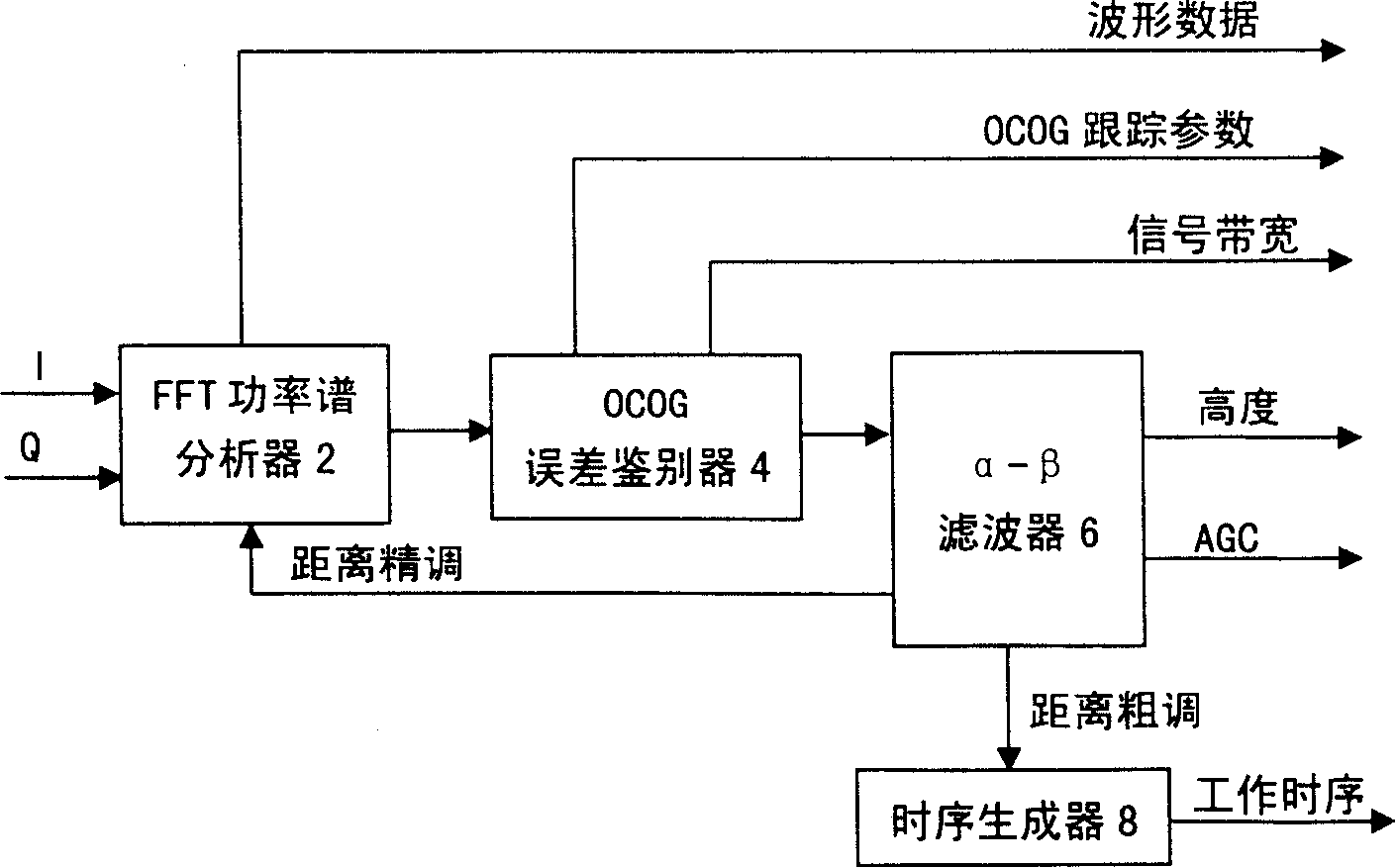
[0023] As shown in Figure 1, the tracker of the present invention consists of three parts. The first part completes the MLE tracking function, the second part completes the OCOG tracking function, and the third part completes the data synthesis processing of the two trackers. The first part includes the first FFT power spectrum analyzer 1, the MLE error discriminator 3 and the first α-β filter 5, and the second part includes the second FFT power spectrum analyzer 2, the OCOG error discriminator 4 and the second α-β filter 6, the third part includes a data synthesis processing unit 7. The first FFT power spectrum analyzer 1 is connected with the receiver of the altimeter, and is electrically connected to the MLE error discriminator 3, the first α-β filter 5 and the data synthesis processing...


PUM


Abstract

The invention discloses a satellite radar altimeter tracker compatible of sea and land, which comprises a first FFT power analyzer, an MLE error discriminator, a first Alpha-Beta filter, a second FFT power analyzer, an OCOG error discriminator, a second Alpha-Beta filter and a data composing treatment unit; wherein, the first FFT power analyzer is electrically connected to the MLE error discriminator, the first Alpha-Beta filter and the data composing treatment unit. The MLE error discriminator is respectively connected with the first Alpha-Beta filter and the data composing treatment unit electrically. The first Alpha-Beta filter is electrically connected with the data composing treatment unit. The second FFT power analyzer is electrically connected with the OCOG error discriminator, and the second Alpha-Beta filter and the data composing treatment unit. The OCOG error discriminator is respectively connected with the second Alpha-Beta filter and the data composing treatment unit electrically. The second Alpha-Beta filter is electrically connected with the data composing treatment unit. The first Alpha-Beta filter is also electrically connected with the second Alpha-Beta filter.

Description

technical field [0001] The present invention relates to a satellite radar altimeter tracker, in particular to a radar altimeter tracker with a maximum likelihood tracking algorithm (maximum likelihood estimation, MLE) and a center of gravity tracking algorithm (off center of gravity, OCOG) working in parallel . Background technique [0002] The satellite radar altimeter is an important remote sensor for the measurement of the ocean dynamic environment. The products directly measured include the height from the satellite to the sea surface, the effective wave height of the sea surface and the backscatter coefficient of the sea surface. The further inversion results of the radar altimeter measurement data can be applied to Marine geophysics, ocean dynamics, marine climate and environment, sea ice monitoring, etc. Among other things, radar altimeters measure sea ice, land-sea topography, and land surface heights. Since the Skylab test in 1973, represented by the United States...

Claims


Application Information

Patent Timeline
Patent Type & Authority Applications(China)
IPC IPC(8): G01S13/08G01S13/89G01S7/02G01C5/00
Inventor 许可刘和光
Owner CENT FOR SPACE SCI & APPLIED RES
Why Eureka
Try Eureka