Method for reflecting regional soil natural erosion degree

A soil erosion and soil technology, applied in soil material testing, special data processing applications, instruments, etc., can solve the problems of expensive monitoring instruments and equipment, lack of spatial variation in reflecting regional soil erosion intensity, long research cycle, etc., to reduce field work Cost, Acquisition and Renewal Efficiency Improvement Effect

Inactive Publication Date: 2008-07-09
GUANGDONG INST OF ECO ENVIRONMENT & SOIL SCI
View PDF0 Cites 32 Cited by
  • Summary
  • Abstract
  • Description
  • Claims
  • Application Information

AI Technical Summary

Problems solved by technology

[0008] Among the main methods used above, their widespread application in practice is limited due to the long research cycle, complex research

Method used


Image

  • Method for reflecting regional soil natural erosion degree
  • Method for reflecting regional soil natural erosion degree
  • Method for reflecting regional soil natural erosion degree

Examples


Embodiment Construction

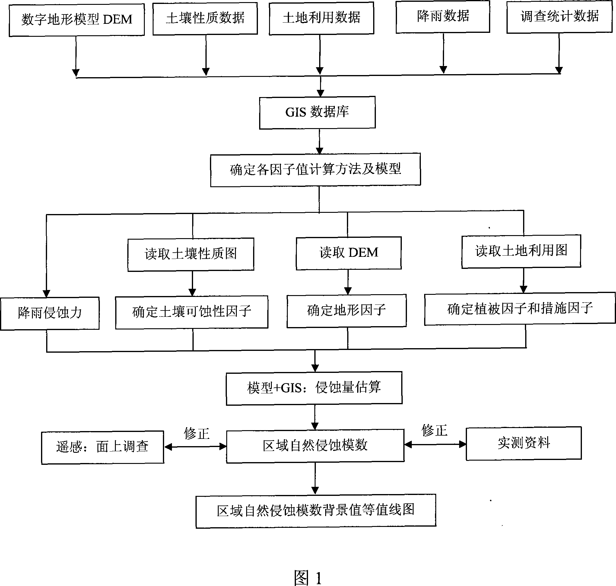
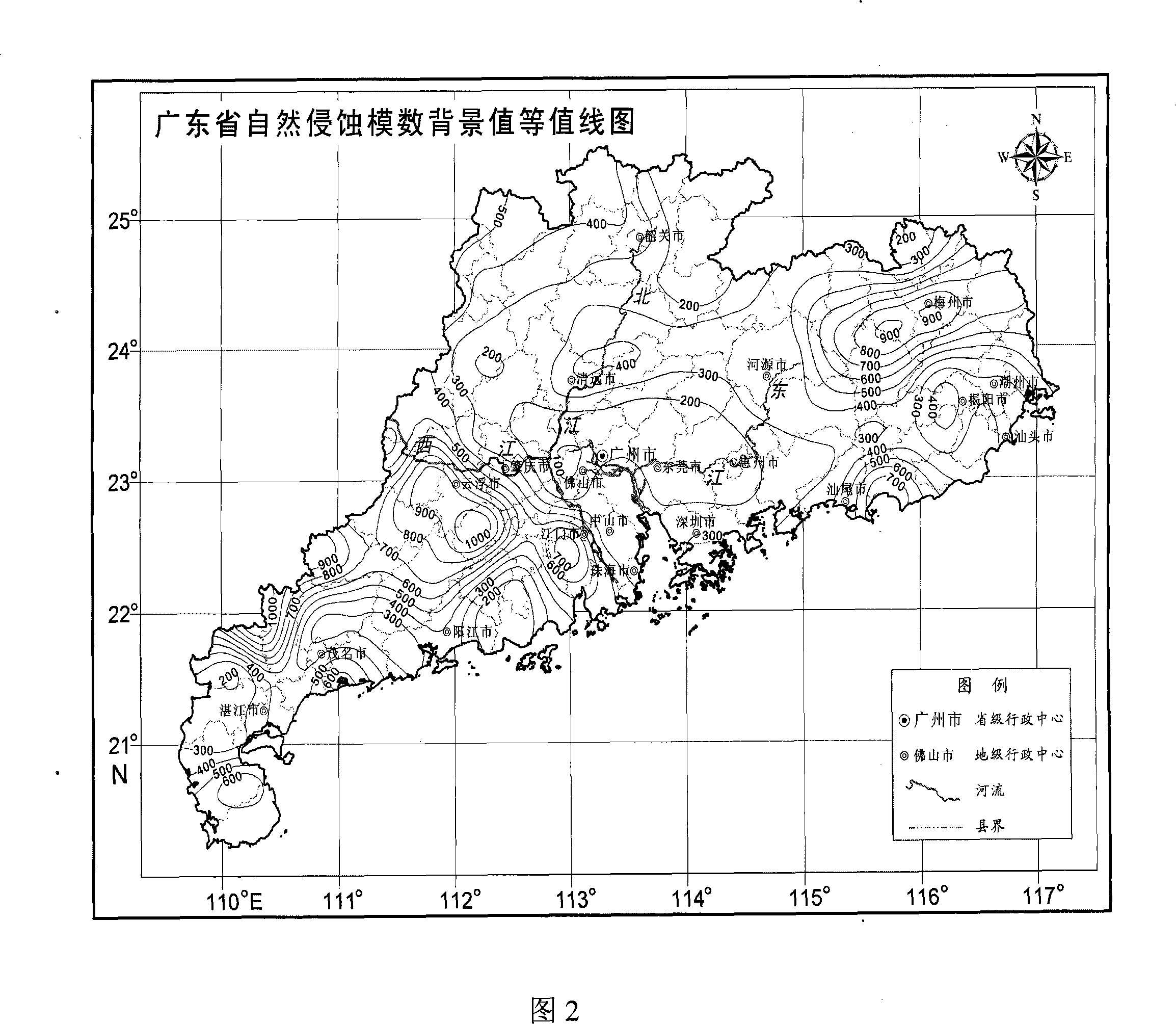
[0017] In order to better implement the present invention, Guangdong Province is taken as an example to further describe the present invention in detail.

[0018] As shown in Figure 1, the detailed steps of the present invention are as follows:

[0019] (1) First, use Arc / Info or ArcView32 to support the general geographic information system GIS software to establish a soil erosion modulus estimation database. The current situation of land use in Guangdong Province in 2000 was interpreted from the data, and with the support of GIS, the land use data of each county, the basic database of 1:200,000 soil types in the whole province, and the spatial data of administrative divisions including county boundaries in the whole province were extracted (Arc / Info data format coverage), the province's 2000 soil erosion remote sensing survey data and key soil and water conservation station monitoring data and county socio-economic statistics (such as area, population, etc.);

[0020] (2) ...


PUM


Abstract

The invention discloses a method for reflecting natural erosion degree of regional soil. The method comprises the following steps pf: inputting each soil erosion factor parameter in a universal geographic information system (GIS) and obtaining erosion modulus based on a universal soil loss (USLE) model; and interpolating the erosion modulus as a sample value by the krige method in the presence of winsurfer software interface to obtain an erosion modulus contour map of the regional soil. The method can directly reflect the spatial change of the erosion intensity of the regional soil and provide rapid and reliable erosion modulus for regional soil and water conservation planning and water and soil conservation, thus multiplying the acquisition and updating efficiency and reducing the fieldwork cost.

Description

technical field [0001] The invention relates to a method for reflecting the degree of soil erosion, in particular to a method for reflecting the degree of natural erosion of regional soil. Background technique [0002] Soil erosion intensity refers to the amount of soil erosion that is eroded and displaced per unit area and per unit period under the combined effects of natural forces (hydraulic, wind, gravity, freeze-thaw, etc.) and human activities on the surface of the earth’s crust. The soil erosion modulus express. The soil erosion modulus represents the amount of soil erosion per unit area and unit period. Its unit name is ton per square kilometer [t / (km 2 a)]. Erosion modulus is an important indicator to quantitatively express regional soil erosion intensity, and it is also an important scientific basis for regional water and soil conservation planning, water and soil conservation program design for development and construction projects, and ecological environment c...

Claims


Application Information

Patent Timeline
IPC IPC(8): G01N33/24G06F17/00
Inventor 吴志峰李定强刘晓南刘平
Owner GUANGDONG INST OF ECO ENVIRONMENT & SOIL SCI
Why Eureka
Try Eureka