Classification method for syncretizing optical spectrum information and multi-point simulation space information

A multi-point simulation and spectral information technology, which is applied in the classification field of fusion spectral information and multi-point simulation spatial information, can solve problems such as the inability to effectively deal with the same object with different spectra and the same spectrum with different objects, so as to reduce time complexity and improve classification The effect of high precision and high precision

Active Publication Date: 2008-10-01
INST OF GEOGRAPHICAL SCI & NATURAL RESOURCE RES CAS
View PDF0 Cites 19 Cited by
  • Summary
  • Abstract
  • Description
  • Claims
  • Application Information

AI Technical Summary

Problems solved by technology

[0004] The technical problem of the present invention is to provide a classification method that fuses spectral information and multi-point analog spatial information. This method effectively uses spectral information and spatial structure information simultaneously in the remote sensing image classification process, which overcomes the inability of traditional remote sensing image classification Effectively deal with the shortcomings of the phenomenon of the same object with different spectra and the same spectrum with different objects, and improve the classification accuracy

Method used


Image

  • Classification method for syncretizing optical spectrum information and multi-point simulation space information
  • Classification method for syncretizing optical spectrum information and multi-point simulation space information
  • Classification method for syncretizing optical spectrum information and multi-point simulation space information

Examples


Embodiment Construction

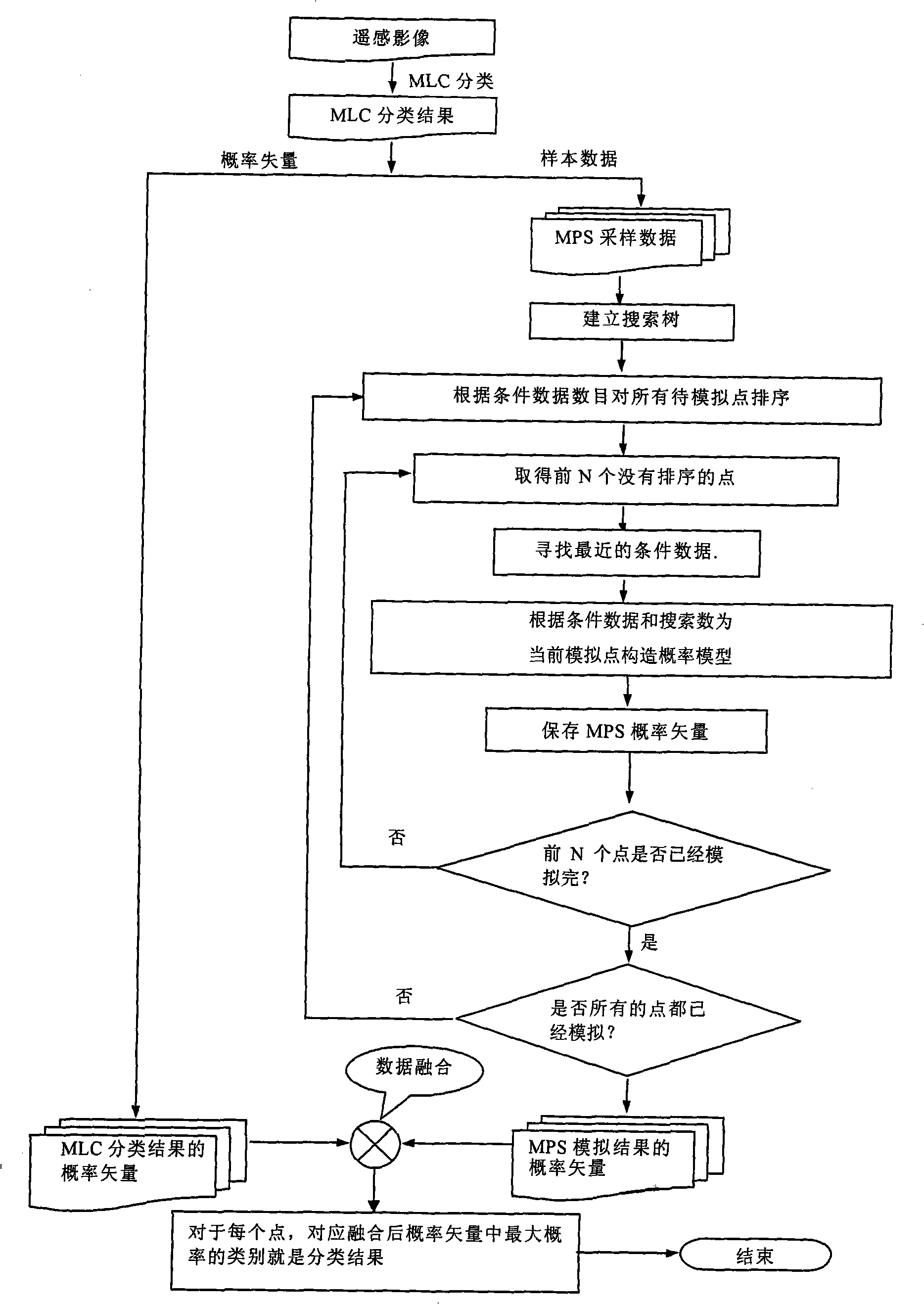
[0041] figure 1 It is a flow chart of the entire classification method of the present invention, and a specific implementation scheme will be given below in conjunction with examples.

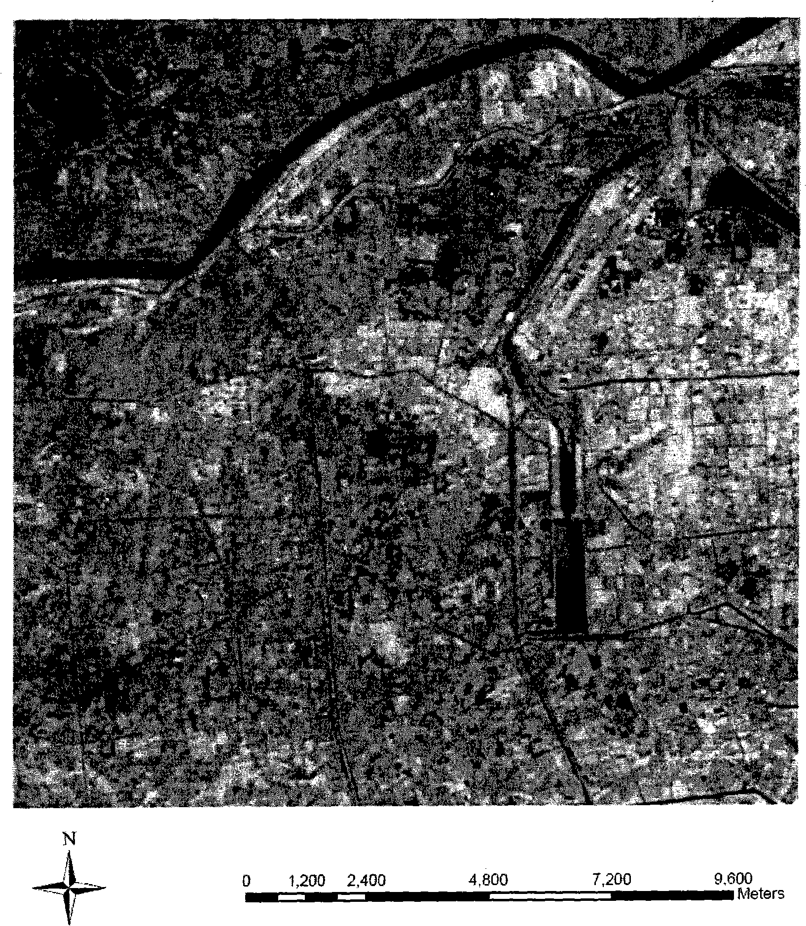
[0042] The experimental data of the algorithm example is selected from the Landsat Tm remote sensing image of the Yellow River Delta area in my country on August 28, 1999 as the experimental data. The image area is located at the junction of Dongying City and Binzhou City in Shandong Province. The image size is 515X515 pixels and the resolution is 30m , consisting of 7 bands, the latitude and longitude coordinates of the upper left corner are 118°0'34.07”E 37°22’24.00”N, and the latitude and longitude coordinates of the lower right corner are 118°10’52.83”E 37°13’58.13”N. figure 2 It is a 5, 4, 3-band false-color composite map of the experimental area.

[0043] The whole implementation process can be divided into three parts, which are MLC classification part, MPS simulation part and data fusi...


PUM


Abstract

A classification method for integrating spectrum information with multipoint simulation space information is disclosed: comprising the steps of: (1) performing MLC classification to pixels of the spectrum information of a remote sense image to obtain possibility vector of each pixel corresponding to each category; (2) selecting sample data for the multipoint simulation MPS; (3) using the multipoint simulation method to establish the possibility model for each pixel in the image according to the number of condition data thereof, and storing the possibility vector; (4) adopting a data integration method to integrate two possibility vectors; (5) obtaining the result which is a possibility vector composed by corresponding each category to the home possibility, in the possibility vector of each pixel, the pixel whose home possibility corresponding to certain category is the largest, is classified to the relative category for the final classification result. The invention improves the classification precision and has extraordinarily extensive application in decoding the remote sense image so that the invention can be applied to the fields of geologic mine, weather, geography, mapping, ocean research, military spy and environmental monitor.

Description

technical field [0001] The invention belongs to the technical field of spatial information, and in particular relates to a classification method for fusing spectral information and multi-point simulated spatial information. technical background [0002] Computer remote sensing image classification is a specific application of statistical pattern recognition technology in the field of remote sensing. The basic process is to extract a set of statistical feature values ​​of the pattern to be recognized, and then make a decision according to certain criteria, and determine the category of each pixel in the image, so as to recognize the digital image. The main basis of remote sensing image classification is the spectral feature, that is, the multi-band measurement value of surface object electromagnetic wave, which is used as the original characteristic variable of remote sensing image classification. However, due to the phenomenon that there are a large number of different obje...

Claims


Application Information

Patent Timeline
Patent Type & Authority Applications(China)
IPC IPC(8): G06K9/62
Inventor 葛咏白鹤翔
Owner INST OF GEOGRAPHICAL SCI & NATURAL RESOURCE RES CAS
Why Eureka
Try Eureka