
Efficient distributed organization and management method for mass remote sensing data

A mass remote sensing data, organization and management technology, applied in the direction of electrical digital data processing, special data processing applications, data acquisition and recording, etc., can solve the problem of few remote sensing data serving end users, difficulties in remote sensing data circulation, remote sensing data storage management, etc. question

Inactive Publication Date: 2009-01-07
BEIHANG UNIV
View PDF0 Cites 64 Cited by
  • Summary
  • Abstract
  • Description
  • Claims
  • Application Information

AI Technical Summary

Problems solved by technology

[0008] At present, most of the domestic remote sensing data are directly stored in the direct producers of the data, and it is difficult for most research institutions and individuals to obtain continuous remote sensing data to carry out applied research, and these remote sensing data rarely serve end users
The direct producers of remote sensing data are facing huge storage pressure, and have not carried out effective storage management for remote sensing data. The most basic file copy method is still used for the acquisition of remote sensing data, which makes the circulation of remote sensing data very difficult.

Method used


Image

  • Efficient distributed organization and management method for mass remote sensing data
  • Efficient distributed organization and management method for mass remote sensing data
  • Efficient distributed organization and management method for mass remote sensing data

Examples


Embodiment Construction

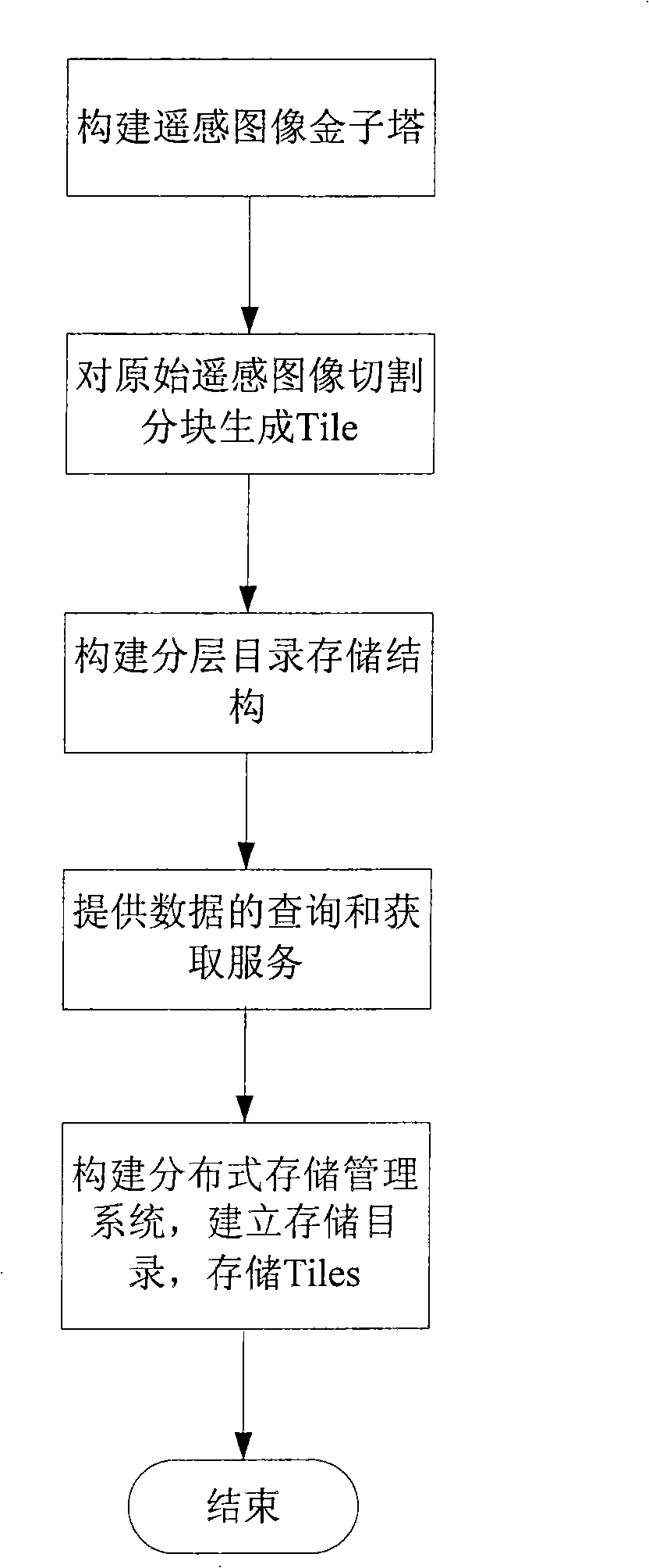
[0085] Such as figure 1 Shown, the realization steps of the present invention are as follows:

[0086] 1. Constructing a remote sensing image pyramid

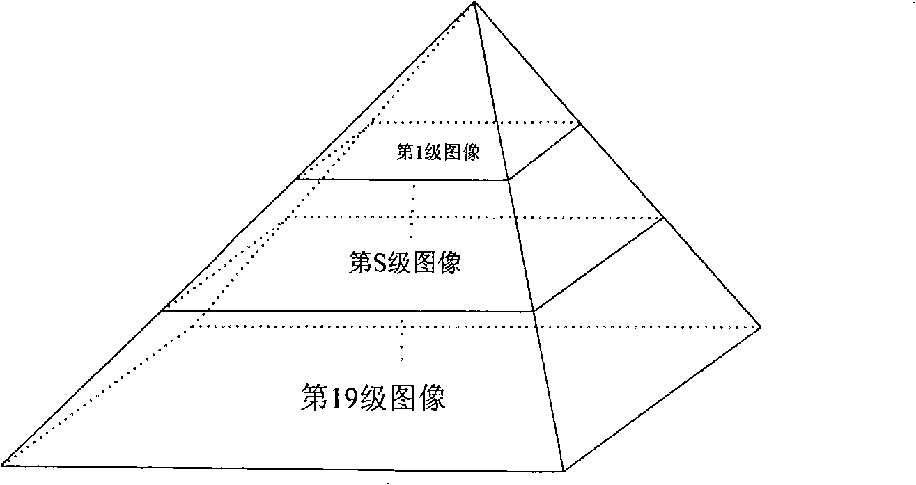
[0087] Due to the multi-resolution characteristics of remote sensing images, the emergence of image pyramid technology is to meet the needs of fast browsing of multi-resolution images. In order to improve the real-time scaling and display speed of images and quickly obtain image information of different resolutions, it is necessary to generate image pyramids for the original remote sensing images, and call images of different resolutions according to different display requirements to achieve the purpose of rapid display roaming.

[0088] In the embodiment of the present invention, the remote sensing image is divided into 19 levels according to the resolution of the remote sensing image, from level 1 to level 19, and each first level corresponds to an image resolution of a specific size, and the higher the level, the higher the...


PUM


Abstract

The invention discloses an efficient massive remote sensing data distributed organization and management method, and the steps are as follows: (1) the first step: a remote sensing image pyramid is constructed according to an original remote sensing image resolution; (2) each layer of the remote sensing image pyramid is cut into blocks based on a Tile technology, and small blocks of images Tiles are formed; (3) based on a file storage system, a layered directory storing structure is built to store the small blocks of images Tiles in the second step; (4) according to the level of a given original remote sensing image and the latitude and longitude coordinate values of a location point, the name of the belonged Tile and the relative storage path of the Tile are calculated, and the quick query and acquisition service of the remote sensing data is realized; and a storage system stores the small blocks of images Tiles in the second step by building the layered directory storing structure; and (5) the architecture of a distributed storage system is adopted to store and manage the layered directory and the small blocks of images Tiles. The method of the invention can be used for effectively storing and managing the remote sensing data which are massive and have multiple sources, multiple resolutions and multiple wave bands, wherein, the layered directory storing structure has the advantages of simple and flexible structure, and easy and convenient data location, and can provide the quick query and acquisition of the remote sensing data, thus being provided with high effectiveness.

Description

technical field [0001] The invention relates to a method for distributed organization and management of massive remote sensing data based on a file system, which is mainly used for storage and management of remote sensing data. Background technique [0002] At the beginning of the 21st century, as photogrammetry technology entered the digital age, and geographic information system and remote sensing technology developed rapidly from the rise, surveying and mapping has undergone tremendous changes, and human society has also made great strides towards an information society. Geographic information systems and remote sensing images have been widely used in various fields of national economic development, and have gradually become an important support for government decision-making, management, engineering planning and design, and enterprise production and operation at all levels. However, in the face of the continuous massive image data brought by digital photogrammetry and re...

Claims


Application Information

Patent Timeline
Patent Type & Authority Applications(China)
IPC IPC(8): G06F17/40G06F17/30G01S17/89
Inventor 马殿富孙晓良赵永望胡春阳邵俊
Owner BEIHANG UNIV
Learn More